Category:Ark's Beschuitfabriek, Heerde
| Object location | | View all coordinates using: OpenStreetMap |
|---|
building in Heerde, Netherlands  | |||||
| Upload media | |||||
| Instance of | |||||
|---|---|---|---|---|---|
| Part of | |||||
| Location | Heerde, Gelderland, Netherlands | ||||
| Street address |
| ||||
| Located on street |
| ||||
| Heritage designation |
| ||||
 | |||||
Nederlands: Ark's Beschuitfabriek
|
This is a category about rijksmonumentcomplex number 520189
|
Ark's bakkerijen (Kantoorgebouw)
|
This is a category about rijksmonument number 520190
|
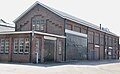
Gasfabriek
|
This is a category about rijksmonument number 520191
|
Opslaggebouw
|
This is a category about rijksmonument number 520192
|
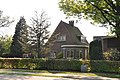
Portierswoning
|
This is a category about rijksmonument number 520193
|
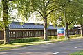
Fabriekshal
|
This is a category about rijksmonument number 520195
|
| Address |
|
Media in category "Ark's Beschuitfabriek, Heerde"
The following 10 files are in this category, out of 10 total.
-
 Beschuitkantoor.jpg 4,288 × 2,848; 6.29 MB
-
 Exterieur OVERZICHT RECHTER ZIJGEVEL - Heerde - 20313699 - RCE.jpg 1,186 × 1,200; 334 KB
-
 Exterieur VOORGEVEL, INGANG MET NAAM - Heerde - 20339716 - RCE.jpg 1,169 × 1,200; 311 KB
-
 Fabriek1.jpg 4,288 × 2,848; 6.16 MB
-
 Fabriek2.jpg 4,288 × 2,848; 6.08 MB
-
 Fabriek3.jpg 4,288 × 2,848; 6.34 MB
-
 Heerde Rijksmonument 520191 beschuitfabriek.jpg 3,830 × 2,365; 3.98 MB
-
 Heerde Rijksmonument 520192 Beschuitfabriek opslag.jpg 4,288 × 2,848; 5.34 MB
-
 Overzicht voorgevel - Heerde - 20359757 - RCE.jpg 1,174 × 1,200; 341 KB
-
 Portierswoning.jpg 4,288 × 2,848; 6.07 MB


