Category:Arundel Avenue entrance to Toxteth Park Cemetery
| Object location | | View all coordinates using: OpenStreetMap |
|---|
building in Liverpool, Merseyside, UK  | |||||
| Upload media | |||||
| Instance of | |||||
|---|---|---|---|---|---|
| Location | Liverpool, Merseyside, North West England, England | ||||
| Heritage designation |
| ||||
 | |||||
Media in category "Arundel Avenue entrance to Toxteth Park Cemetery"
The following 6 files are in this category, out of 6 total.
-
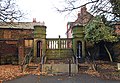 Arundel Avenue entrance to Toxteth Park Cemetery 1.jpg 4,885 × 3,361; 9.87 MB
-
 Arundel Avenue entrance to Toxteth Park Cemetery 2.jpg 4,308 × 3,360; 8.05 MB
-
 Arundel Avenue entrance to Toxteth Park Cemetery 3.jpg 4,429 × 3,174; 8.91 MB
-
 Arundel Avenue entrance to Toxteth Park Cemetery 4.jpg 4,421 × 3,515; 10.19 MB
-
 Closing times, Arundel Avenue entrance, Toxteth Park Cemetery.jpg 4,168 × 3,224; 6.39 MB
-
 Toxteth Cemetery June 10 2010.jpg 3,072 × 2,304; 1.2 MB


