Category:As River Outfall
Afrikaans: Die Asrivieruitval, 1740 m bo seevlak en 9 km noord van Clarens, oos-Vrystaat, is die noordelike eindpunt van die Lesotho-Hoogland-waterprojek se Leweringstonnel-noord. Fase 1A van die projek was van 1991 tot 1996 onder konstruksie, en die Leweringstonnel-noord is op 23 Januarie 1998 ingewy.
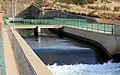
English: The As River Outfall, at 1740 above sea level and 9 km north of Clarens, eastern Free State, is the northern end of the Delivery Tunnel North of the Lesotho Highlands Water Project. Phase 1A of the construction project lasted from 1991 to 1996, and the Delivery Tunnel North was officially opened on 23 January 1998.
| Object location | | View all coordinates using: OpenStreetMap |
|---|
an outlet of the Lesotho Highlands Water Project  | |||||
| Upload media | |||||
| Instance of |
| ||||
|---|---|---|---|---|---|
| Location | Dihlabeng Local Municipality, Thabo Mofutsanyana District Municipality, Free State, RSA | ||||
| Elevation above sea level |
| ||||
| Mouth of the watercourse | |||||
 | |||||
Media in category "As River Outfall"
The following 16 files are in this category, out of 16 total.
-
 Ash River Outfall - panoramio (1).jpg 1,600 × 1,200; 294 KB
-
 Ash River Outfall - panoramio (2).jpg 1,600 × 1,200; 103 KB
-
 Ash River Outfall - panoramio (3).jpg 1,600 × 1,200; 115 KB
-
 Ash River Outfall - panoramio.jpg 1,600 × 1,200; 256 KB
-
 Asrivieruitval, noord van Clarens, a.jpg 4,000 × 3,000; 3.86 MB
-
 Asrivieruitval, noord van Clarens, b.jpg 4,000 × 3,000; 3.84 MB
-
 Asrivieruitval, noord van Clarens, c.jpg 4,000 × 3,000; 4.67 MB
-
 Asrivieruitval, noord van Clarens, d.jpg 4,000 × 3,000; 3.88 MB
-
 Asrivieruitval, noord van Clarens, e.jpg 4,000 × 3,000; 4.75 MB
-
 Asrivieruitval, noord van Clarens, f.jpg 4,000 × 3,000; 4.73 MB
-
 Bethlehem, South Africa - panoramio (17).jpg 1,936 × 2,592; 1.73 MB
-
 Bethlehem, South Africa - panoramio (18).jpg 2,592 × 1,936; 1.7 MB
-
 Bethlehem, South Africa - panoramio (19).jpg 2,592 × 1,936; 2.73 MB
-
 Delivery Tunnel to the outfall on the Ash River - panoramio.jpg 1,440 × 900; 712 KB
-
 Katse Water 81Km away @ Ash River - panoramio.jpg 1,600 × 1,200; 574 KB
-
 Voorafvervaardigde betonring, 5 segmente en sluitsteen, Asrivieruitval.jpg 3,620 × 3,000; 3.53 MB
.jpg)
.jpg)
.jpg)


.jpg)
.jpg)
.jpg)

