Category:Ascutney Mill Dam Historic District
| Object location | | View all coordinates using: OpenStreetMap |
|---|
|
This is a category about a place or building that is listed on the National Register of Historic Places in the United States of America. Its reference number is 06001236. |
dam in Windsor, Vermont  | |||||
| Upload media | |||||
| Instance of | |||||
|---|---|---|---|---|---|
| Location | Windsor, Windsor County, Vermont | ||||
| Street address |
| ||||
| Heritage designation |
| ||||
 | |||||
Media in category "Ascutney Mill Dam Historic District"
The following 3 files are in this category, out of 3 total.
-
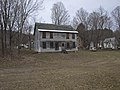
 Ascutney Mill.jpg 3,648 × 2,736; 6.76 MB
-
 Ascutney Mill2.jpg 3,648 × 2,736; 6.79 MB
-
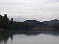 Mill Pond.jpg 3,408 × 2,538; 3.46 MB

