Category:Ashby Parkland
English: Ashby Parkland is a civil parish in North Lincolnshire, England. The parish was created on April 1, 2004, and was previously part of the Burringham parish. The parish consists of a few fields and hamlets to the immediate west of Scunthorpe, and to the east of the M181, which marks the border with Burringham.
civil parish in Lincolnshire, United Kingdom | |||||
| Upload media | |||||
| Instance of | |||||
|---|---|---|---|---|---|
| Location | North Lincolnshire, Lincolnshire, Yorkshire and the Humber, England | ||||
 | |||||
Subcategories
This category has the following 3 subcategories, out of 3 total.
Media in category "Ashby Parkland"
The following 28 files are in this category, out of 28 total.
-
 Alongside the railway - geograph.org.uk - 1906609.jpg 1,600 × 1,200; 326 KB
-
 Ashby Decoy Farm - geograph.org.uk - 495260.jpg 640 × 480; 51 KB
-
 Brumby Common Lane - geograph.org.uk - 3831113.jpg 640 × 480; 64 KB
-
 Brumby Common Lane - geograph.org.uk - 3831117.jpg 640 × 480; 60 KB
-
 Carisbrooke Manor - geograph.org.uk - 272576.jpg 640 × 427; 54 KB
-
 Cars parked at Oglesby Park - geograph.org.uk - 5958240.jpg 640 × 480; 128 KB
-
 Cloud above the snow - geograph.org.uk - 2195789.jpg 1,024 × 670; 88 KB
-
 Communications mast - geograph.org.uk - 3831115.jpg 480 × 640; 41 KB
-
 Crop field beside the M181 - geograph.org.uk - 3831100.jpg 640 × 480; 42 KB
-
 Earl Beauchamp's Warping Drain - geograph.org.uk - 181541.jpg 640 × 427; 92 KB
-
 Earl Beauchamp's Warping Drain - geograph.org.uk - 5958259.jpg 640 × 480; 56 KB
-
 Farmland and woodland, Brumby Grove - geograph.org.uk - 3831116.jpg 640 × 480; 57 KB
-
 Farmland east of M181 motorway near Scunthorpe - geograph.org.uk - 4635402.jpg 1,024 × 768; 139 KB
-
 Farmland east of the M181 - geograph.org.uk - 4174408.jpg 640 × 443; 39 KB
-

-
 Following the railway embankment into Scunthorpe - geograph.org.uk - 4799497.jpg 3,776 × 2,520; 3.93 MB
-
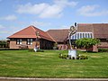 Lindsey Lodge Hospice - geograph.org.uk - 1257953.jpg 640 × 480; 76 KB
-
 M181 Northbound - geograph.org.uk - 5380893.jpg 640 × 427; 179 KB
-
 Path below railway embankment - geograph.org.uk - 5677242.jpg 5,376 × 3,024; 4.12 MB
-
 Ponies near Carisbrooke Manor - geograph.org.uk - 272579.jpg 640 × 427; 42 KB
-
 Road leading to Scunthorpe - geograph.org.uk - 5380844.jpg 640 × 427; 186 KB
-
 Runners on the bridge - geograph.org.uk - 5380888.jpg 640 × 427; 206 KB
-
 Snow covered fields - geograph.org.uk - 2195775.jpg 1,024 × 768; 123 KB
-
 Temporary access to Frodingham Viaduct - geograph.org.uk - 1906625.jpg 1,600 × 1,200; 328 KB
-
 The view from the footbridge over Bridges Road - geograph.org.uk - 4026159.jpg 1,600 × 960; 357 KB
-
 Track on Brumby West Common - geograph.org.uk - 5380851.jpg 640 × 427; 199 KB
-
 View looking eastwards along Brumby Common Lane - geograph.org.uk - 1911723.jpg 1,600 × 1,200; 337 KB
-
 View towards Carisbrooke Manor - geograph.org.uk - 2195805.jpg 1,024 × 768; 88 KB


_-_geograph.org.uk_-_4174401.jpg)


