Category:Ashton-in-Makerfield War Memorial
| Object location | | View all coordinates using: OpenStreetMap |
|---|
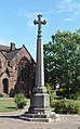
WWI & WWII memorial in the shape of cross at St Thomas's church, Ashton-in-Makerfield, Wigan, Greater Manchester, UK  | |||||
| Upload media | |||||
| Instance of | |||||
|---|---|---|---|---|---|
| Commemorates | |||||
| Location | St Thomas' Church, Ashton-in-Makerfield, Wigan, Greater Manchester, North West England, England | ||||
 | |||||
War memorial in the shape of a cross to the south of St Thomas's Church, Ashton-in-Makerfield, commemmorates First and Second World wars.
Media in category "Ashton-in-Makerfield War Memorial"
The following 4 files are in this category, out of 4 total.
-

-
 Ashton-in-Makerfield War Memorial 1.jpg 3,250 × 5,150; 20.63 MB
-
 Ashton-in-Makerfield War Memorial 2.jpg 2,965 × 5,157; 19.15 MB
-
 Ashton-in-Makerfield War Memorial 3.jpg 3,093 × 4,989; 20.36 MB


