Category:Asserstraat 93 (Zuidvelde)
| Object location | | View all coordinates using: OpenStreetMap |
|---|
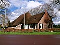
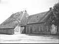
farmhouse in Noordenveld, Netherlands  | |||||
| Upload media | |||||
| Instance of | |||||
|---|---|---|---|---|---|
| Location | Zuidvelde, Noordenveld, Drenthe, Netherlands | ||||
| Street address |
| ||||
| Located on street |
| ||||
| Heritage designation |
| ||||
 | |||||
|
This is a category about rijksmonument number 30813
|
| Address |
|
Media in category "Asserstraat 93 (Zuidvelde)"
The following 8 files are in this category, out of 8 total.
-
 Asserstraat 93 v1.jpg 4,608 × 3,456; 3.42 MB
-
 Asserstraat 93 v2.jpg 4,608 × 3,456; 3.3 MB
-
 Exterieur - Zuidvelde - 20225831 - RCE.jpg 1,200 × 957; 253 KB
-
 Overzicht vanuit het noord-westen - Zuidvelde - 20225820 - RCE.jpg 1,200 × 800; 240 KB
-
 Voor- en zijgevel nr. F 288-34 - Zuidvelde - 20491359 - RCE.jpg 1,200 × 900; 169 KB
-
 Zij- en kopgevel nr. L 120 - Zuidvelde - 20476753 - RCE.jpg 1,200 × 900; 122 KB
-
 Zij- en voorgevel nr. F 288-33 - Zuidvelde - 20491357 - RCE.jpg 1,200 × 900; 121 KB
-
 Zijgevel nr. F 288-32 - Zuidvelde - 20491356 - RCE.jpg 1,200 × 900; 139 KB


