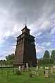
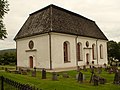
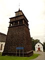
Category:Attmars kyrka
| Object location | | View all coordinates using: OpenStreetMap |
|---|
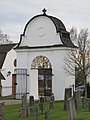
church building in Sundsvall Municipality, Sweden    | |||||
| Upload media | |||||
| Instance of | |||||
|---|---|---|---|---|---|
| Location | Attmar, Medelpad, Västernorrland County, Sweden | ||||
| Diocese | |||||
| Connects with |
| ||||
| Has use |
| ||||
| Occupant | |||||
| Heritage designation |
| ||||
| Inception |
| ||||
 | |||||
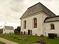
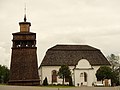
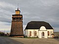
Svenska: Attmars kyrka tillhör Attmars församling, Ljunga kontrakt, Härnösands stift / Diocese of Härnösand.
|
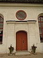
This is a category about an ecclesiastical monument in Sweden, number 21300000005368 in the RAÄ buildings database.
|
Subcategories
This category has the following 3 subcategories, out of 3 total.
- Interior of Attmars kyrka (25 F)
M
- Medelpads runinskrifter 4 (12 F)
- Medelpads runinskrifter 5 (19 F)
Media in category "Attmars kyrka"
The following 70 files are in this category, out of 70 total.
-
 Attmars kyrka - KMB - 16000200043633.jpg 765 × 600; 75 KB
-
 Attmars kyrka - KMB - 16000200043634.jpg 443 × 600; 20 KB
-
 Attmars kyrka - KMB - 16000200043635.jpg 800 × 591; 38 KB
-
 Attmars kyrka - KMB - 16000200043636.jpg 800 × 578; 29 KB
-
 Attmars kyrka - KMB - 16000200043638.jpg 427 × 600; 11 KB
-
 Attmars kyrka - KMB - 16000200043640.jpg 800 × 569; 40 KB
-
 Attmars kyrka - KMB - 16000200043644.jpg 811 × 600; 46 KB
-
 Attmars kyrka - KMB - 16000200043645.jpg 800 × 590; 41 KB
-
 Attmars kyrka - KMB - 16000200043646.jpg 800 × 598; 40 KB
-
 Attmars kyrka - KMB - 16000200043664.jpg 442 × 600; 23 KB
-
 Attmars kyrka - KMB - 16000200043670.jpg 444 × 600; 21 KB
-
 Attmars kyrka - KMB - 16000200043672.jpg 800 × 521; 20 KB
-
 Attmars kyrka - KMB - 16000200043674.jpg 436 × 600; 19 KB
-
 Attmars kyrka - KMB - 16000200043675.jpg 441 × 600; 19 KB
-
 Attmars kyrka - KMB - 16000200043676.jpg 445 × 600; 19 KB
-
 Attmars kyrka - KMB - 16000200043677.jpg 427 × 600; 17 KB
-
 Attmars kyrka - KMB - 16000200043678.jpg 444 × 600; 17 KB
-
 Attmars kyrka - KMB - 16000200043748.jpg 800 × 595; 36 KB
-
 Attmars kyrka - KMB - 16000200043749.jpg 800 × 572; 51 KB
-
 Attmars kyrka - KMB - 16000200043750.jpg 800 × 569; 51 KB
-
 Attmars kyrka - KMB - 16000200043751.jpg 800 × 591; 44 KB
-
 Attmars kyrka - KMB - 16000200043820.jpg 800 × 578; 37 KB
-
 Attmars kyrka - KMB - 16000200043821.jpg 800 × 599; 34 KB
-
 Attmars kyrka - KMB - 16000200043822.jpg 450 × 600; 21 KB
-
 Attmars kyrka - KMB - 16000200043823.jpg 455 × 600; 23 KB
-
 Attmars kyrka - KMB - 16000200043824.jpg 351 × 600; 12 KB
-
 Attmars kyrka - KMB - 16000200043825.jpg 450 × 600; 31 KB
-
 Attmars kyrka - KMB - 16000200043826.jpg 379 × 600; 12 KB
-
 Attmars kyrka - KMB - 16000200043828.jpg 441 × 600; 15 KB
-
 Attmars kyrka - KMB - 16000200043829.jpg 602 × 600; 19 KB
-
 Attmars kyrka - KMB - 16000200043830.jpg 800 × 548; 15 KB
-
 Attmars kyrka - KMB - 16000200043832.jpg 800 × 552; 17 KB
-
 Attmars kyrka - KMB - 16000200043833.jpg 439 × 600; 15 KB
-
 Attmars kyrka - KMB - 16000200043834.jpg 574 × 600; 43 KB
-
 Attmars kyrka - KMB - 16000200043835.jpg 417 × 600; 18 KB
-
 Attmars kyrka - KMB - 16000200043836.jpg 459 × 600; 19 KB
-
 Attmars kyrka - KMB - 16000200043837.jpg 421 × 600; 18 KB
-
 Attmars kyrka - KMB - 16000200043838.jpg 440 × 600; 28 KB
-
 Attmars kyrka - KMB - 16000200043839.jpg 443 × 600; 17 KB
-
 Attmars kyrka - KMB - 16000200043840.jpg 434 × 600; 16 KB
-
 Attmars kyrka - KMB - 16000200043841.jpg 439 × 600; 24 KB
-
 Attmars kyrka - KMB - 16000200043842.jpg 440 × 600; 20 KB
-
 Attmars kyrka - KMB - 16000200043843.jpg 436 × 600; 17 KB
-
 Attmars kyrka - KMB - 16000200043844.jpg 800 × 548; 49 KB
-
 Attmars kyrka - KMB - 16000300026245.jpg 768 × 512; 91 KB
-
 Attmars kyrka - KMB - 16000300026246.jpg 768 × 512; 96 KB
-
 Attmars kyrka - KMB - 16000300026248.jpg 512 × 768; 92 KB
-
 Attmars kyrka - KMB - 16000300027187.jpg 512 × 768; 114 KB
-
 Attmars kyrka 01.JPG 3,968 × 2,976; 2.25 MB
-
 Attmars kyrka 02.JPG 2,976 × 3,968; 1.66 MB
-
 Attmars kyrka 03.jpg 2,848 × 2,136; 1.47 MB
-
 Attmars kyrka 04.JPG 2,976 × 3,968; 1.74 MB
-
 Attmars kyrka 05.JPG 3,968 × 2,976; 2.15 MB
-
 Attmars kyrka 06.JPG 3,968 × 2,976; 2.17 MB
-
 Attmars kyrka 07.JPG 3,968 × 2,976; 2.35 MB
-
 Attmars kyrka 08.JPG 2,976 × 3,968; 1.82 MB
-
 Attmars kyrka 09.JPG 2,976 × 3,968; 1.61 MB
-
 Attmars kyrka 10.JPG 3,968 × 2,976; 2.01 MB
-
 Attmars kyrka 11.JPG 3,968 × 2,976; 1.94 MB
-
 Attmars kyrka 12.JPG 2,976 × 3,968; 2.15 MB
-
 Attmars kyrka 13.JPG 2,976 × 3,968; 1.99 MB
-
 Attmars kyrka 14.JPG 2,976 × 3,968; 2.17 MB
-
 Attmars kyrka 15.JPG 3,968 × 2,976; 1.67 MB
-
 Attmars kyrka 16.JPG 3,968 × 2,976; 1.99 MB
-
 Attmars kyrka ext1.jpg 4,000 × 3,000; 3 MB
-
 Attmars kyrka ext2.jpg 4,000 × 3,000; 2.17 MB
-
 Attmars kyrka ext3.jpg 4,000 × 3,000; 2.76 MB
-
 Attmars kyrka ext4.jpg 4,000 × 3,000; 2.77 MB
-
 Attmars kyrka ext5.jpg 3,000 × 4,000; 2.71 MB
-
 Attmars kyrka ext6.jpg 3,000 × 4,000; 2.05 MB


