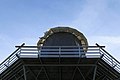
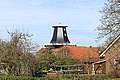
Category:Backemoorer Mühle
| Object location | | View all coordinates using: OpenStreetMap |
|---|
 | |||||
| Upload media | |||||
| Instance of | |||||
|---|---|---|---|---|---|
| Location | Q798381, Rhauderfehn, Leer, Lower Saxony, Germany | ||||
| Inception |
| ||||
| Source of energy |
| ||||
 | |||||
Media in category "Backemoorer Mühle"
The following 9 files are in this category, out of 9 total.
-
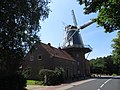 Mühle Rhauderfehn-Backemoor Juli 2022.jpg 4,000 × 3,000; 3.62 MB
-
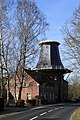
 Rhauderfehn - Backemoorer Straße + Backemoorer Mühle 01 ies.jpg 5,616 × 3,744; 17.39 MB
-
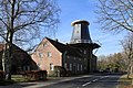
 Rhauderfehn - Backemoorer Straße + Backemoorer Mühle 02 ies.jpg 3,744 × 5,616; 22.6 MB
-
 Rhauderfehn - Backemoorer Straße + Backemoorer Mühle 03 ies.jpg 5,616 × 3,744; 22.64 MB
-
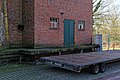
 Rhauderfehn - Backemoorer Straße - Backemoorer Mühle 01 ies.jpg 3,745 × 5,616; 15.13 MB
-
 Rhauderfehn - Backemoorer Straße - Backemoorer Mühle 02 ies.jpg 5,616 × 3,744; 25.47 MB
-
 Rhauderfehn - Backemoorer Straße - Backemoorer Mühle 03 ies.jpg 5,616 × 3,744; 22.82 MB
-
 Rhauderfehn - Backemoorer Straße - Backemoorer Mühle 04 ies.jpg 5,616 × 3,744; 15.13 MB
-
 Rhauderfehn - Backemoorer Straße - Backemoorer Mühle 05 ies.jpg 5,616 × 3,744; 22.98 MB


