Category:Bainton, East Riding of Yorkshire
English: Bainton is a village and civil parish in the East Riding of Yorkshire, England. It is situated approximately 6 miles (9.7 km) south-west of Driffield. It is located on the A614 road.
village and civil parish in the East Riding of Yorkshire, UK  | |||||
| Upload media | |||||
| Instance of | |||||
|---|---|---|---|---|---|
| Location | East Riding of Yorkshire, Yorkshire and the Humber, England | ||||
| Said to be the same as | Bainton (Wikimedia duplicated page, civil parish) | ||||
 | |||||
Subcategories
This category has the following 5 subcategories, out of 5 total.
A
Media in category "Bainton, East Riding of Yorkshire"
The following 200 files are in this category, out of 210 total.
(previous page) (next page)-
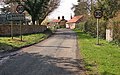
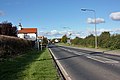
 'Bainton' Roundabout - geograph.org.uk - 110593.jpg 640 × 480; 149 KB
-
 A Bridge but no Track - geograph.org.uk - 2237543.jpg 3,648 × 2,736; 3.76 MB
-
 A footpath off Neswick Lane, Bainton - geograph.org.uk - 2261230.jpg 800 × 600; 273 KB
-
 A footpath to North Dalton - geograph.org.uk - 2261284.jpg 800 × 600; 288 KB
-
 A footpath to North Dalton - geograph.org.uk - 2261294.jpg 800 × 600; 247 KB
-
 A knotted tree, south of Kirkburn ^1 - geograph.org.uk - 2261186.jpg 600 × 800; 361 KB
-
 A knotted tree, south of Kirkburn ^2 - geograph.org.uk - 2261193.jpg 600 × 800; 364 KB
-

-
 A163 - B1248 Junction, south of Bainton - geograph.org.uk - 1013153.jpg 640 × 427; 167 KB
-
 A614 approaching Bainton Roundabout - geograph.org.uk - 5429789.jpg 640 × 398; 63 KB
-
 A614 near Bainton Windmill - geograph.org.uk - 5429790.jpg 640 × 398; 57 KB
-
 A614 towards Middleton - geograph.org.uk - 1496189.jpg 640 × 480; 51 KB
-
 A614 towards Middleton - geograph.org.uk - 1496224.jpg 640 × 480; 46 KB
-
 A614 towards Middleton - geograph.org.uk - 1496245.jpg 640 × 480; 55 KB
-
 Agricultural graveyard - geograph.org.uk - 5898162.jpg 1,024 × 768; 322 KB
-
 Alongside High Wood - geograph.org.uk - 5708062.jpg 1,024 × 768; 167 KB
-
 Alongside High Wood - geograph.org.uk - 5898164.jpg 1,024 × 768; 183 KB
-
 Applegarth Lane, Bainton - geograph.org.uk - 804854.jpg 640 × 401; 210 KB
-
 Applegarth Lane, East of Bainton - geograph.org.uk - 1453811.jpg 640 × 480; 109 KB
-
 Approaching Bainton roundabout - geograph.org.uk - 4139335.jpg 4,608 × 3,456; 3.28 MB
-
 B1246 heading north east - geograph.org.uk - 5251945.jpg 640 × 480; 69 KB
-
 B1246 towards Driffield - geograph.org.uk - 5251135.jpg 640 × 480; 51 KB
-
 B1246 towards Driffield - geograph.org.uk - 5251141.jpg 640 × 480; 79 KB
-
 B1246 towards Driffield - geograph.org.uk - 5251940.jpg 640 × 480; 48 KB
-
 B1246 towards North Dalton - geograph.org.uk - 1414012.jpg 640 × 480; 90 KB
-
 B1246 towards North Dalton - geograph.org.uk - 1414036.jpg 640 × 480; 71 KB
-
 B1248 towards Bainton - geograph.org.uk - 1395408.jpg 640 × 480; 80 KB
-
 B1248 towards Bainton - geograph.org.uk - 1496403.jpg 640 × 480; 72 KB
-
 Bainton Balk Farm - geograph.org.uk - 110565.jpg 640 × 480; 149 KB
-
 Bainton Balk Farm - geograph.org.uk - 2098560.jpg 1,024 × 768; 171 KB
-
 Bainton Balk Farm - geograph.org.uk - 5251957.jpg 640 × 480; 50 KB
-
 Bainton Church from Dead Lane. - geograph.org.uk - 1035682.jpg 640 × 480; 77 KB
-
 Bainton layby off A614 - geograph.org.uk - 4497926.jpg 1,024 × 768; 149 KB
-
 Bainton Methodist Church - geograph.org.uk - 2195462.jpg 4,000 × 3,000; 3.07 MB
-
 Bainton Mill, East Riding-geograph.org-1684284.jpg 514 × 640; 190 KB
-
 Bainton Road - geograph.org.uk - 541959.jpg 480 × 640; 81 KB
-
 Bainton Roundabout - geograph.org.uk - 541955.jpg 640 × 480; 77 KB
-
 Bainton War Memorial - geograph.org.uk - 5466034.jpg 799 × 1,200; 394 KB
-
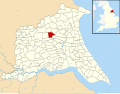 Bainton, East Riding of Yorkshire UK parish locator map.svg 1,425 × 1,107; 1.68 MB
-
 Beacon Farm - geograph.org.uk - 1414005.jpg 640 × 480; 100 KB
-
 Beacon Wood - geograph.org.uk - 1413994.jpg 640 × 480; 142 KB
-
 Beautiful Cherry Blossom at Bainton Church Gate - geograph.org.uk - 5771404.jpg 2,048 × 1,536; 1.68 MB
-
 Beverley 10 Miles - geograph.org.uk - 5251956.jpg 640 × 480; 41 KB
-
 Bio crop and field edge - geograph.org.uk - 2104405.jpg 4,000 × 3,000; 3.14 MB
-
 Blossom at Bainton Church Gate - geograph.org.uk - 3956363.jpg 4,320 × 3,240; 5.17 MB
-
 Blossom in Applegarth Lane Bainton - geograph.org.uk - 3955036.jpg 4,320 × 3,240; 5.03 MB
-
 Bridge for Nothing - geograph.org.uk - 2172581.jpg 3,648 × 2,736; 3.76 MB
-
 Bridge on a country lane - geograph.org.uk - 2104395.jpg 4,000 × 3,000; 3.37 MB
-
 Bridge on Burnbutts Lane - geograph.org.uk - 5950835.jpg 1,600 × 1,064; 622 KB
-
 Bridleway at SE947546 - geograph.org.uk - 268971.jpg 640 × 480; 129 KB
-
 Bridleway beside High Wood - geograph.org.uk - 1395429.jpg 640 × 480; 61 KB
-
 Bridleway near Tibthorpe - geograph.org.uk - 1395416.jpg 640 × 495; 123 KB
-
 Bridleway to Tibthorpe - geograph.org.uk - 2275774.jpg 1,024 × 768; 142 KB
-
 Bridleway towards Huggate - geograph.org.uk - 1395487.jpg 640 × 480; 114 KB
-
 By Low Wood, near Tibthorpe - geograph.org.uk - 4964138.jpg 640 × 427; 420 KB
-
 Close up, Elizabeth II postbox on Main Street, Bainton - geograph.org.uk - 5250162.jpg 1,147 × 2,202; 471 KB
-
 Cottage on Back Street, Bainton - geograph.org.uk - 5251946.jpg 640 × 480; 47 KB
-
 Cottages in Applegarth Lane, Bainton - geograph.org.uk - 804549.jpg 640 × 344; 167 KB
-

-

-

-
 Crop Field near Field House Farm - geograph.org.uk - 1395465.jpg 640 × 480; 91 KB
-
 Dead Lane, Bainton - geograph.org.uk - 2261264.jpg 800 × 600; 321 KB
-
 Disused Railway Line - geograph.org.uk - 6868.jpg 640 × 480; 117 KB
-
 East of Bainton - geograph.org.uk - 110571.jpg 640 × 480; 163 KB
-
 East of North Dalton - geograph.org.uk - 110582.jpg 640 × 480; 119 KB
-

-
 Elizabeth II postbox on Main Street, Bainton - geograph.org.uk - 5250161.jpg 2,259 × 1,878; 959 KB
-
 Entering Bainton - geograph.org.uk - 5251942.jpg 640 × 480; 65 KB
-
 Entering Bainton from the south - geograph.org.uk - 1046047.jpg 640 × 427; 296 KB
-
 Entering Bainton, A614 - geograph.org.uk - 5429791.jpg 640 × 426; 80 KB
-
 Entering Bainton, East Yorkshire - geograph.org.uk - 2261238.jpg 800 × 600; 332 KB
-
 Entrance to Bainton Lodge - geograph.org.uk - 5251976.jpg 640 × 480; 122 KB
-
 Exiting the gate at St Andrew's Church Bainton - geograph.org.uk - 3956403.jpg 4,320 × 3,240; 4.24 MB
-
 Farm Road to B1246 - geograph.org.uk - 2195461.jpg 4,000 × 3,000; 2.51 MB
-
 Farm Track beside High Wood - geograph.org.uk - 1395473.jpg 640 × 480; 84 KB
-
 Farm track to Field House Farm - geograph.org.uk - 5898155.jpg 1,024 × 768; 261 KB
-
 Farmland and High Wood - geograph.org.uk - 269034.jpg 640 × 480; 113 KB
-
 Farmland East of Bainton - geograph.org.uk - 1453814.jpg 640 × 480; 88 KB
-
 Farmland North of HIgh Wood - geograph.org.uk - 1395478.jpg 640 × 480; 75 KB
-
 Farmland West of Tibthorpe - geograph.org.uk - 1395626.jpg 640 × 480; 79 KB
-
 Field Boundary and Hedgerow - geograph.org.uk - 1395439.jpg 640 × 480; 66 KB
-

-

-
 Field east of North Dalton - geograph.org.uk - 5251133.jpg 640 × 480; 51 KB
-
 Field Edge - geograph.org.uk - 617082.jpg 640 × 480; 91 KB
-
 Field entrance off the B1246 - geograph.org.uk - 5251143.jpg 640 × 480; 66 KB
-
 Field tree, east of the lay-by - geograph.org.uk - 2098555.jpg 1,024 × 768; 203 KB
-
 Fields west of Tibthorpe - geograph.org.uk - 4964117.jpg 483 × 640; 345 KB
-
 Fingerpost at Oldfield Lane (geograph 5950841).jpg 1,064 × 1,600; 998 KB
-
 Footpath at SE985523 - geograph.org.uk - 90072.jpg 480 × 640; 245 KB
-
 Footpath from the church - geograph.org.uk - 3187024.jpg 1,024 × 768; 219 KB
-
 Footpath near Bainton - geograph.org.uk - 1453816.jpg 640 × 480; 103 KB
-
 Footpath near Bainton - geograph.org.uk - 6108650.jpg 1,024 × 768; 219 KB
-
 Footpath over the fields at the corner - geograph.org.uk - 5205473.jpg 2,304 × 1,728; 1,022 KB
-
 Footpath to Neswick - geograph.org.uk - 2237516.jpg 3,648 × 2,736; 3.4 MB
-
 Footpath to Neswick Lane (geograph 5416335).jpg 1,024 × 768; 210 KB
-
 Footpath to the church - geograph.org.uk - 3191340.jpg 1,024 × 768; 211 KB
-
 Gated Field Entrance - geograph.org.uk - 1496203.jpg 640 × 480; 88 KB
-
 Going green - geograph.org.uk - 2098562.jpg 1,024 × 768; 155 KB
-
 Gravelwalk Plantation - geograph.org.uk - 270739.jpg 640 × 480; 103 KB
-
 Heading east from North Dalton - geograph.org.uk - 5251136.jpg 640 × 480; 73 KB
-
 Hedgerow on the Sheepwalk, Bainton - geograph.org.uk - 5898137.jpg 1,024 × 768; 145 KB
-
 Hedgerow on the Sheepwalk, Bainton - geograph.org.uk - 5898147.jpg 1,024 × 768; 158 KB
-
 Ivy Cottage, Bainton - geograph.org.uk - 365050.jpg 640 × 480; 124 KB
-
 Ivy Covered Cottage - geograph.org.uk - 3859647.jpg 800 × 600; 241 KB
-
 Large layby off A614 Bainton - geograph.org.uk - 4497930.jpg 1,024 × 768; 115 KB
-
 Lay-by on the A164 near Bainton - geograph.org.uk - 1496182.jpg 640 × 480; 45 KB
-
 Lay-by on the A614 - geograph.org.uk - 2098554.jpg 1,024 × 768; 135 KB
-
 Lay-by on the A614 - geograph.org.uk - 2098556.jpg 1,024 × 768; 141 KB
-
 Levelled Crossing - geograph.org.uk - 2172560.jpg 2,736 × 3,648; 2.19 MB
-
 Looking down the B1246 - geograph.org.uk - 2005812.jpg 800 × 600; 259 KB
-
 Looking south towards Barton Burrows - geograph.org.uk - 2261297.jpg 800 × 600; 209 KB
-
 Low Wood - East - geograph.org.uk - 110727.jpg 640 × 480; 109 KB
-
 Low Wood - geograph.org.uk - 269015.jpg 640 × 480; 100 KB
-
 Low Wood - West - geograph.org.uk - 110721.jpg 640 × 480; 168 KB
-
 Low Wood from the west - geograph.org.uk - 2195177.jpg 4,000 × 3,000; 3.17 MB
-
 Low Wood to the south of Tibthorpe - geograph.org.uk - 2287312.jpg 800 × 600; 218 KB
-
 Manor Farm near Bainton - geograph.org.uk - 10565.jpg 640 × 480; 165 KB
-
 Minor road south of Kirkburn - geograph.org.uk - 2104411.jpg 4,000 × 3,000; 2.94 MB
-
 Minor Road Towards Bainton - geograph.org.uk - 1414023.jpg 640 × 480; 73 KB
-
 Minor Road Towards Neswick - geograph.org.uk - 1351339.jpg 640 × 480; 61 KB
-
 Minster Way - geograph.org.uk - 5236758.jpg 640 × 480; 81 KB
-
 Neswick Farm - geograph.org.uk - 1453820.jpg 640 × 480; 62 KB
-
 Neswick Farm - geograph.org.uk - 6108651.jpg 1,024 × 768; 147 KB
-

-
 Neswick Lane - geograph.org.uk - 1453822.jpg 640 × 502; 91 KB
-
 Neswick Lane - geograph.org.uk - 2104397.jpg 4,000 × 3,000; 2.25 MB
-
 Neswick Lane - geograph.org.uk - 2336583.jpg 640 × 480; 46 KB
-
 Neswick Lane toward Neswick Farm - geograph.org.uk - 5205496.jpg 2,304 × 1,728; 849 KB
-
 Neswick Park - geograph.org.uk - 3187016.jpg 1,024 × 768; 148 KB
-
 New planting at Low Wood - geograph.org.uk - 3991976.jpg 1,024 × 768; 213 KB
-
 Old milepost sign by A. A. - geograph.org.uk - 1035693.jpg 480 × 640; 90 KB
-
 Old railway bridge on Burnbutts Lane - detail - geograph.org.uk - 5537705.jpg 1,024 × 768; 632 KB
-
 Old railway bridge on Burnbutts Lane - geograph.org.uk - 5537702.jpg 1,024 × 768; 883 KB
-
 Oldfield Lane (geograph 5416342).jpg 1,024 × 768; 198 KB
-
 Oldfield Lane - geograph.org.uk - 5416347.jpg 1,024 × 768; 176 KB
-
 Oldfield Lane - geograph.org.uk - 5416351.jpg 1,024 × 768; 185 KB
-
 Oldfield Lane near Bainton (geograph 5413534).jpg 1,024 × 768; 166 KB
-
 Oldfield Lane near Bainton - geograph.org.uk - 6108680.jpg 1,024 × 768; 267 KB
-
 One Hundred Years of History - Gone^ - geograph.org.uk - 2237538.jpg 3,648 × 2,736; 4.06 MB
-
 Only 207 miles to London - geograph.org.uk - 2261258.jpg 800 × 600; 320 KB
-
 Pastures north of Bainton - geograph.org.uk - 804851.jpg 640 × 304; 107 KB
-
 Path at SE990526 - geograph.org.uk - 252269.jpg 640 × 480; 112 KB
-
 Path Leading to Burnbutts Lane - geograph.org.uk - 5950824.jpg 1,600 × 1,064; 762 KB
-
 Path leading to Oldfield Lane - geograph.org.uk - 5950836.jpg 1,600 × 1,064; 808 KB
-
 Path leading to Oldfield Lane - geograph.org.uk - 5950839.jpg 1,600 × 1,064; 861 KB
-
 Path to Bustardnest Fox Covert (geograph 6495319).jpg 5,456 × 3,632; 2.46 MB
-
 Peeping over the hedge - geograph.org.uk - 2098552.jpg 1,024 × 768; 138 KB
-
 Ploughed field and hedgerow - geograph.org.uk - 5251982.jpg 640 × 480; 52 KB
-
 Railway Cottages - geograph.org.uk - 5251964.jpg 640 × 465; 45 KB
-
 Road to Westfield Farm - geograph.org.uk - 5251139.jpg 640 × 480; 67 KB
-
 Roadside Hedgerow and Trees - geograph.org.uk - 1414016.jpg 640 × 480; 102 KB
-
 Sheepwalk, Bainton - geograph.org.uk - 5898116.jpg 1,024 × 768; 131 KB
-
 Southburn Road - geograph.org.uk - 5252697.jpg 1,024 × 768; 204 KB
-
 St Andrew's Church, Bainton - geograph.org.uk - 5466023.jpg 918 × 1,200; 494 KB
-
 St Andrew's Church, Bainton - geograph.org.uk - 5466042.jpg 799 × 1,200; 306 KB
-
 St Andrew's Church, Bainton - geograph.org.uk - 5466049.jpg 636 × 1,200; 351 KB
-
 St Andrew's Church, Bainton - geograph.org.uk - 5466062.jpg 782 × 1,200; 423 KB
-
 St Andrew's Church, Bainton - geograph.org.uk - 5466091.jpg 1,200 × 799; 328 KB
-
 St Andrew's Church, Bainton - geograph.org.uk - 5466098.jpg 826 × 1,200; 493 KB
-
 St Andrew's Church, Bainton - geograph.org.uk - 5466106.jpg 1,200 × 799; 354 KB
-
 St Andrew's Church, Bainton - geograph.org.uk - 5466115.jpg 867 × 1,200; 543 KB
-
 St Andrew's Church, Bainton - geograph.org.uk - 5466121.jpg 734 × 1,200; 494 KB
-
 St Andrew's Church, Bainton - geograph.org.uk - 5466235.jpg 1,200 × 799; 334 KB
-
 St Andrew's church, Bainton - geograph.org.uk - 5783977.jpg 2,592 × 1,944; 2.21 MB
-
 St Andrew's church, Bainton - geograph.org.uk - 5783979.jpg 1,843 × 2,457; 965 KB
-
 St Andrew's Church, Bainton - geograph.org.uk - 5997427.jpg 1,024 × 768; 239 KB
-
 St Andrews Church, Bainton - geograph.org.uk - 2261246.jpg 800 × 600; 336 KB
-
 Station Road (B1248) - geograph.org.uk - 5251960.jpg 640 × 480; 46 KB
-
 Station Road (B1248) - geograph.org.uk - 5251993.jpg 640 × 446; 53 KB
-
 Stubble field on the Sheepwalk - geograph.org.uk - 5898177.jpg 1,024 × 768; 142 KB
-
 Sunflowers in the sun - geograph.org.uk - 2005805.jpg 800 × 600; 190 KB
-
 SW of Southburn - geograph.org.uk - 90083.jpg 640 × 480; 126 KB
-

-
 The garden wall of the Old Rectory, Bainton - geograph.org.uk - 3191336.jpg 1,024 × 768; 296 KB
-
 The joining of roads - geograph.org.uk - 2005809.jpg 800 × 600; 198 KB
-
 The Minster Way - geograph.org.uk - 5236764.jpg 640 × 480; 76 KB
-
 The Minster Way - geograph.org.uk - 5411584.jpg 1,024 × 768; 179 KB
-
 The Minster Way entering Bainton - geograph.org.uk - 5411586.jpg 1,024 × 768; 340 KB
-
 The Road to Southburn - geograph.org.uk - 2237550.jpg 3,648 × 2,736; 2.94 MB
-
 The Sheepwalk, Bainton - geograph.org.uk - 5898143.jpg 1,024 × 768; 165 KB
-
 The Sheepwalk, Bainton - geograph.org.uk - 5898151.jpg 1,024 × 768; 148 KB
-
 The way into Beacon Wood, Neswick - geograph.org.uk - 252925.jpg 640 × 482; 195 KB
-
 The way to Bainton Burrows Farm - geograph.org.uk - 2389565.jpg 800 × 600; 307 KB
-

-
 Towards Low Wood, near Tibthorpe - geograph.org.uk - 4964122.jpg 640 × 427; 398 KB
-
 Track beside Beacon Wood - geograph.org.uk - 1413999.jpg 640 × 480; 122 KB
-
 Track into High Wood - geograph.org.uk - 5898128.jpg 1,024 × 768; 327 KB
-
 Track through Beacon Wood - geograph.org.uk - 1413990.jpg 640 × 480; 107 KB
-
 Track to Bainton Burrows Farm - geograph.org.uk - 1496237.jpg 640 × 447; 63 KB
-
 Track to Bainton Heights Farm - geograph.org.uk - 1414032.jpg 640 × 480; 89 KB
-
 Track to Field House Farm - geograph.org.uk - 1395457.jpg 640 × 480; 94 KB
-
 Track to Field House Farm - geograph.org.uk - 1414028.jpg 640 × 480; 74 KB
-
 Track's Gone - geograph.org.uk - 2172569.jpg 2,736 × 3,648; 2.73 MB
-
 Two cottages in Bainton - geograph.org.uk - 804858.jpg 640 × 427; 215 KB
-
 Unusual house chimney. - geograph.org.uk - 1035701.jpg 480 × 640; 68 KB
-
 View From High Wood - geograph.org.uk - 269024.jpg 640 × 480; 108 KB
-
 View towards Bainton Balk Farm - geograph.org.uk - 4321160.jpg 1,024 × 768; 168 KB
-
 Waiting for the newly married couple - geograph.org.uk - 3191312.jpg 1,024 × 745; 218 KB


.jpg)


.jpg)


.jpg)


.jpg)


.jpg)


_-_geograph.org.uk_-_5251960.jpg)
_-_geograph.org.uk_-_5251993.jpg)


,_Bainton_-_geograph.org.uk_-_5251947.jpg)


