Category:Ballot measure maps of Oklahoma
States of the United States: Alabama · Alaska · Arizona · Arkansas · California · Colorado · Connecticut · Delaware · Florida · Georgia · Hawaii · Idaho · Illinois · Indiana · Iowa · Kansas · Kentucky · Louisiana · Maine · Maryland · Massachusetts · Michigan · Minnesota · Mississippi · Missouri · Montana · Nebraska · Nevada · New Hampshire · New Jersey · New Mexico · New York · North Carolina · North Dakota · Ohio · Oklahoma · Oregon · Pennsylvania · Rhode Island · South Carolina · South Dakota · Tennessee · Texas · Utah · Vermont · Virginia · Washington · West Virginia · Wisconsin · Wyoming
Media in category "Ballot measure maps of Oklahoma"
The following 12 files are in this category, out of 12 total.
-
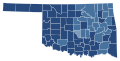 2004 Oklahoma Question 711.svg 744 × 378; 266 KB
-
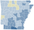 2012 Arkansas Issue 1 results.svg 810 × 709; 45 KB
-
 2016 OK state question 777 results.svg 800 × 395; 635 KB
-
 2016 Oklahoma State Question 777 by precinct.svg 1,895 × 913; 10.45 MB
-
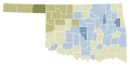 2018 Oklahoma Question 788 results map by county.svg 744 × 378; 266 KB
-
 2018 Oklahoma State Question 788 results map by precinct.svg 3,784 × 1,923; 17.87 MB
-
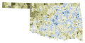
 2020 Oklahoma Question 802.svg 744 × 378; 266 KB
-
 2023 Oklahoma State Question 820 results map by congressional district.svg 3,784 × 1,923; 1,016 KB
-
 2023 Oklahoma State Question 820 results map by county.svg 810 × 404; 32 KB
-
 2023 Oklahoma State Question 820 results map by precinct.svg 3,648 × 1,819; 17.03 MB
-
 2023 Oklahoma State Question 820 results map by state house district.svg 3,784 × 1,923; 3.23 MB
-
 2023 Oklahoma State Question 820 results map by state senate district.svg 3,784 × 1,923; 2.35 MB


