Category:Ballycotton Lighthouse
| Object location | | View all coordinates using: OpenStreetMap |
|---|
English: Ballycotton Lighthouse
lighthouse in Ireland  | |||||
| Upload media | |||||
| Instance of | |||||
|---|---|---|---|---|---|
| Location | County Cork, Munster, Ireland | ||||
| Located in or next to body of water | |||||
| Operator |
| ||||
| Service entry |
| ||||
| Date of official opening |
| ||||
| Significant event |
| ||||
| Height |
| ||||
 | |||||
Media in category "Ballycotton Lighthouse"
The following 10 files are in this category, out of 10 total.
-
 Ballycotton Bay Lighthouse (3288423898).jpg 2,592 × 1,944; 1.19 MB
-
 Ballycotton Bay Lighthouse - Closer View (3287604619).jpg 2,592 × 1,944; 1.16 MB
-
 Ballycotton Cliff Walk.jpg 4,276 × 2,851; 4.33 MB
-

-
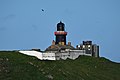 Ballycotton Lighthouse Co Cork.jpg 640 × 427; 189 KB
-
 Ballycotton Lighthouse, view from Ballycotton.jpg 3,222 × 2,417; 1.51 MB
-
 Ballycotton Lighthouse.jpg 4,032 × 3,024; 2.75 MB
-
 Ballycotton Lighthouse.png 2,816 × 1,183; 5.11 MB
-
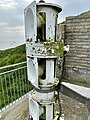 Foghorn on Ballycotton Island.jpg 2,441 × 3,255; 2.46 MB
-
 View from Ballycotton (geograph 4171849).jpg 1,927 × 3,000; 5.5 MB
.jpg)
.jpg)


.jpg)