Category:Ballyculter, County Down
English: Ballyculter is a civil parish in County Down, Northern Ireland. It is situated in the historic barony of Lecale Lower.
Media in category "Ballyculter, County Down"
The following 8 files are in this category, out of 8 total.
-
 Croplands north of the Audleystown Road - geograph.org.uk - 3543951.jpg 1,024 × 768; 180 KB
-
 Graves in Ballyculter Churchyard - geograph.org.uk - 2530861.jpg 1,024 × 768; 307 KB
-
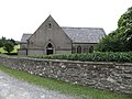 St Tassoch's Chapel, Audleystown Road - geograph.org.uk - 3542638.jpg 1,024 × 768; 225 KB
-
 Staggered crossroads at Churchtown, Ballyculter - geograph.org.uk - 2530831.jpg 1,024 × 768; 264 KB
-
 The western end of Audleystown Road - geograph.org.uk - 3542502.jpg 1,024 × 768; 143 KB
-
 Track through Audleystown Wood - geograph.org.uk - 3543626.jpg 1,024 × 768; 376 KB
-

-
 View east along Audleystown Road - geograph.org.uk - 3542506.jpg 1,024 × 768; 238 KB


