Category:Barbarossaweg 2 (Barum)
This is the category for an architectural monument.
It is on the list of cultural monuments of Barum.
|
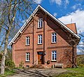
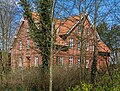
Clergy house, built in 1889 (date of the weather vane)
- Free-standing, single-storey brick building on low brick plinth with extended jamb storey under widely projecting gable roof with hollow pantile roofing
- Four-axis dwarf house on the south-eastern eaves side
- Facade articulation by pilaster strips, friezes and gable framing in brick decoration
- Representative entrance door with staircase in front on the south-western gable end
Clergy house in Barum, Lower Saxony, Germany  | |||||
| Upload media | |||||
| Instance of | |||||
|---|---|---|---|---|---|
| Location | Barum, Lüneburg, Lower Saxony, Germany | ||||
| Street address |
| ||||
| Heritage designation | |||||
 | |||||
Media in category "Barbarossaweg 2 (Barum)"
The following 5 files are in this category, out of 5 total.
-
 Barum Barbarossaweg 2 001 2023 04 02.jpg 3,660 × 3,388; 6.61 MB
-
 Barum Barbarossaweg 2 002 2023 04 02.jpg 3,687 × 3,760; 5.65 MB
-
 Barum Barbarossaweg 2 003 2023 04 02.jpg 3,878 × 3,551; 6.51 MB
-
 Barum Barbarossaweg 2 004 2023 04 02.jpg 3,782 × 2,877; 6.19 MB
-
 Barum Barbarossaweg 2 005 2023 04 02.jpg 4,538 × 3,142; 8.64 MB


