Category:Bartholomeuskerk (Blijdenstein)
| Object location | | View all coordinates using: OpenStreetMap |
|---|
church building in De Wolden, Netherlands  | |||||
| Upload media | |||||
| Instance of | |||||
|---|---|---|---|---|---|
| Location | Ruinerwold, De Wolden, Drenthe, Netherlands | ||||
| Street address |
| ||||
| Located on street |
| ||||
| Heritage designation |
| ||||
| Inception |
| ||||
 | |||||
Nederlands: Bartholomeus, Ruinerwold (Blijdenstein) - Anno 15e eeuw
|
This is a category about rijksmonument number 32983
|
| Address |
|
Media in category "Bartholomeuskerk (Blijdenstein)"
The following 48 files are in this category, out of 48 total.
-
 Beëindiging oost schippeiler - Blijdenstein - 20035735 - RCE.jpg 1,200 × 788; 146 KB
-

-
 De Wolden - Blijdenstein - Bartholomeus.jpg 2,560 × 1,920; 2.17 MB
-
 Ingang noordzijde - Blijdenstein - 20351909 - RCE.jpg 776 × 1,200; 302 KB
-
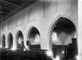 Interieur - Blijdenstein - 20035710 - RCE.jpg 1,200 × 875; 103 KB
-
 Interieur naar het oosten - Blijdenstein - 20035709 - RCE.jpg 1,200 × 959; 198 KB
-
 Interieur naar het oosten na de restauratie - Blijdenstein - 20035715 - RCE.jpg 1,200 × 902; 144 KB
-
 Interieur naar het westen - Blijdenstein - 20035708 - RCE.jpg 1,200 × 959; 196 KB
-
 Interieur naar het westen na de restauratie - Blijdenstein - 20035711 - RCE.jpg 1,200 × 905; 190 KB
-
 Interieur naar het westen na de restauratie - Blijdenstein - 20035712 - RCE.jpg 1,200 × 894; 152 KB
-
 Interieur naar het westen na de restauratie - Blijdenstein - 20035713 - RCE.jpg 1,200 × 893; 151 KB
-
 Interieur naar het westen na de restauratie - Blijdenstein - 20035714 - RCE.jpg 1,200 × 864; 154 KB
-

-
 Inwendig - Blijdenstein - 20035717 - RCE.jpg 1,200 × 897; 130 KB
-
 Kap koor naar het oosten - Blijdenstein - 20035728 - RCE.jpg 1,200 × 782; 177 KB
-
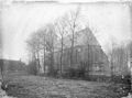
 Kerk - Blijdenstein - 20035706 - RCE.jpg 1,200 × 944; 260 KB
-
 Kerk naar het noord-westen - Blijdenstein - 20035707 - RCE.jpg 1,200 × 959; 277 KB
-
 Kerk naar het noord-westen na de restauratie - Blijdenstein - 20035705 - RCE.jpg 1,200 × 893; 237 KB
-

-
 Kerk naar het noorden na de restauratie - Blijdenstein - 20035704 - RCE.jpg 1,200 × 887; 277 KB
-
 Kerk naar het oosten na de restauratie - Blijdenstein - 20035699 - RCE.jpg 889 × 1,200; 218 KB
-
 Kerk naar het westen na de restauratie - Blijdenstein - 20035700 - RCE.jpg 897 × 1,200; 234 KB
-
 Kerk naar het zuid-westen na de restauratie - Blijdenstein - 20035702 - RCE.jpg 1,200 × 891; 207 KB
-
 Kerk naar het zuid-westen na de restauratie - Blijdenstein - 20035703 - RCE.jpg 1,200 × 889; 213 KB
-
 Kerk naar het zuiden na de restauratie - Blijdenstein - 20035701 - RCE.jpg 1,200 × 886; 250 KB
-
 Kerk te Ruinerwold.JPG 3,264 × 2,448; 3.85 MB
-
 Kerk vanuit het noord-oosten - Blijdenstein - 20035698 - RCE.jpg 1,200 × 883; 206 KB
-
 Kerk vanuit het zuid-oosten - Blijdenstein - 20035697 - RCE.jpg 937 × 1,200; 172 KB
-
 Noord wand toren - Blijdenstein - 20035731 - RCE.jpg 1,200 × 785; 109 KB
-
 Noord zijbeuk kraagsteen - Blijdenstein - 20035732 - RCE.jpg 1,200 × 773; 134 KB
-
 Noord zijde koor steunbeer - Blijdenstein - 20035733 - RCE.jpg 777 × 1,200; 124 KB
-
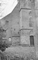
 Noord-gevel Toren - Blijdenstein - 20035723 - RCE.jpg 779 × 1,200; 236 KB
-
 Noord-zijde van het koor - Blijdenstein - 20035734 - RCE.jpg 1,200 × 788; 157 KB
-
 Oost gevel toren, interieur - Blijdenstein - 20035726 - RCE.jpg 1,200 × 783; 141 KB
-

-
 Plattegrond en doorsnede - Blijdenstein - 20035694 - RCE.jpg 893 × 1,200; 120 KB
-
 Schip kap naar het oosten - Blijdenstein - 20035727 - RCE.jpg 1,200 × 782; 169 KB
-
 Toren - Blijdenstein - 20035695 - RCE.jpg 873 × 1,200; 255 KB
-
 Toren zuid-west zijde - Blijdenstein - 20035720 - RCE.jpg 787 × 1,200; 164 KB
-
 Voorgevel - Blijdenstein - 20035740 - RCE.jpg 1,195 × 1,200; 363 KB
-
 West-gevel zijbeuk interieur - Blijdenstein - 20035729 - RCE.jpg 1,200 × 778; 210 KB
-
 West-gevel zijbeuk interieur - Blijdenstein - 20035730 - RCE.jpg 1,200 × 776; 168 KB
-
 West-zijde exterieur - Blijdenstein - 20035724 - RCE.jpg 766 × 1,200; 282 KB
-
 West-zijde exterieur - Blijdenstein - 20035725 - RCE.jpg 1,200 × 783; 279 KB
-
 Zuid-gevel detail - Blijdenstein - 20035718 - RCE.jpg 958 × 1,200; 393 KB
-
 Zuid-gevel detail - Blijdenstein - 20035719 - RCE.jpg 956 × 1,200; 416 KB
-
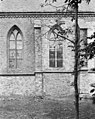
 Zuid-gevel exterieur - Blijdenstein - 20035722 - RCE.jpg 1,200 × 788; 314 KB
-
 Zwerfsteen onder de toren.jpg 5,184 × 3,888; 8.32 MB


