Category:Baydon
village in the United Kingdom  | |||||
| Upload media | |||||
| Instance of | |||||
|---|---|---|---|---|---|
| Location | Wiltshire, South West England, England | ||||
| Population |
| ||||
| official website | |||||
 | |||||
Nederlands: Baydon is een civil parish in de unitary authority Wiltshire, in het Engelse graafschap Wiltshire. De civil parish telt
Subcategories
This category has only the following subcategory.
B
- St Nicholas' Church, Baydon (4 F)
Media in category "Baydon"
The following 200 files are in this category, out of 221 total.
(previous page) (next page)-
 A Bit of Baydon - geograph.org.uk - 3877069.jpg 1,600 × 1,148; 373 KB
-

-
 Aldbourne Road at the junction of Barley Fields - geograph.org.uk - 5483016.jpg 1,960 × 1,412; 931 KB
-
 Aldbourne Road entering Baydon - geograph.org.uk - 5481244.jpg 2,048 × 1,536; 1.48 MB
-
 Bailey Hill Cottages - geograph.org.uk - 4998501.jpg 4,000 × 3,000; 4.92 MB
-
 Bailey Hill Farm - geograph.org.uk - 3876779.jpg 1,024 × 768; 239 KB
-
 Baydon Road west of Baydon - geograph.org.uk - 5909772.jpg 1,824 × 1,114; 1.49 MB
-

-

-
 Baydon Village School - geograph.org.uk - 3914375.jpg 1,600 × 1,200; 515 KB
-
 Baydon Village Store - geograph.org.uk - 817273.jpg 640 × 480; 68 KB
-
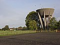
 Baydon Water Tower - geograph.org.uk - 3877047.jpg 1,546 × 1,069; 527 KB
-
 Baydon, Red Lion - geograph.org.uk - 817251.jpg 640 × 480; 87 KB
-
 Bridge over M4 - geograph.org.uk - 6373695.jpg 1,024 × 512; 142 KB
-

-
 Bridleway through Webb's Wood - geograph.org.uk - 1219983.jpg 640 × 480; 281 KB
-
 Byway heading to Common Barn Copse - geograph.org.uk - 3291994.jpg 640 × 480; 90 KB
-
 Byway to Aldbourne, west of Baydon - geograph.org.uk - 1384716.jpg 640 × 480; 181 KB
-
 Byway, Bailey Hill - geograph.org.uk - 4994277.jpg 4,000 × 3,000; 4.9 MB
-
 Cottage with Eyes - geograph.org.uk - 3876766.jpg 1,024 × 783; 318 KB
-
 Cottages in Baydon - geograph.org.uk - 817243.jpg 640 × 480; 131 KB
-
 Deer near Baydon Wood - geograph.org.uk - 6410714.jpg 4,000 × 3,000; 5.85 MB
-
 Derelict barn above Ford Farm - geograph.org.uk - 6356708.jpg 4,000 × 3,000; 5.12 MB
-
 Derelict building near Brickkiln Copse - geograph.org.uk - 6406929.jpg 4,000 × 3,000; 4.84 MB
-

-

-

-
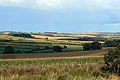
 Downland below Baydon - geograph.org.uk - 988244.jpg 640 × 480; 140 KB
-
 Downland Fields near Baydon - geograph.org.uk - 3878056.jpg 1,600 × 1,297; 641 KB
-
 Downland near Baydon - geograph.org.uk - 988253.jpg 640 × 480; 125 KB
-
 Downland west of Baydon - geograph.org.uk - 1384706.jpg 640 × 480; 117 KB
-
 Downland, Baydon - geograph.org.uk - 727020.jpg 640 × 480; 159 KB
-
 Downland, Baydon - geograph.org.uk - 727078.jpg 640 × 480; 141 KB
-
 Downsmead, Baydon - geograph.org.uk - 3973295.jpg 1,024 × 768; 156 KB
-
 Eastbound M4, Peaks Downs - geograph.org.uk - 3415238.jpg 640 × 427; 331 KB
-
 Entrance to bridleway near Baydon House Farm - geograph.org.uk - 6356689.jpg 4,000 × 3,000; 4.6 MB
-
 Ermin Street, Baydon - geograph.org.uk - 5910996.jpg 1,892 × 1,236; 1.35 MB
-
 Fallow deer near Baydon - geograph.org.uk - 4990585.jpg 4,000 × 3,000; 4.66 MB
-
 Fallow deer near Baydon - geograph.org.uk - 4990595.jpg 4,000 × 3,000; 2.22 MB
-
 Fallow deer near Baydon - geograph.org.uk - 4990611.jpg 4,000 × 3,000; 2.53 MB
-
 Fallow deer near Baydon - geograph.org.uk - 4990614.jpg 4,000 × 3,000; 2.8 MB
-
 Fallow deer near Baydon - geograph.org.uk - 4990616.jpg 3,904 × 2,952; 2.6 MB
-
 Fallow deer near Baydon - geograph.org.uk - 4990619.jpg 4,000 × 3,000; 2.9 MB
-
 Fallow deer near Baydon - geograph.org.uk - 5234846.jpg 4,000 × 3,000; 4.63 MB
-
 Farmland above Aldbourne - geograph.org.uk - 248813.jpg 640 × 478; 146 KB
-
 Farmland above Aldbourne - geograph.org.uk - 988297.jpg 640 × 480; 91 KB
-
 Farmland near Aldbourne - geograph.org.uk - 248822.jpg 640 × 478; 110 KB
-
 Farmland near Baydon - geograph.org.uk - 256728.jpg 640 × 480; 143 KB
-
 Farmland near Baydon - geograph.org.uk - 256738.jpg 640 × 480; 110 KB
-
 Farmland near Baydon, Wiltshire - geograph.org.uk - 948879.jpg 640 × 480; 109 KB
-
 Farmland south of Baydon - geograph.org.uk - 988237.jpg 640 × 480; 135 KB
-
 Farmland west of Baydon, Wiltshire - geograph.org.uk - 1384294.jpg 640 × 480; 188 KB
-
 Farmland, Baydon - geograph.org.uk - 254538.jpg 640 × 480; 111 KB
-
 Farmland, Baydon - geograph.org.uk - 6080516.jpg 1,024 × 768; 209 KB
-
 Farmland, Baydon - geograph.org.uk - 6080519.jpg 768 × 1,024; 266 KB
-
 Farmland, Baydon - geograph.org.uk - 727109.jpg 640 × 480; 151 KB
-
 Farmland, Baydon - geograph.org.uk - 727176.jpg 640 × 480; 131 KB
-
 Farmland, Baydon - geograph.org.uk - 727192.jpg 640 × 480; 92 KB
-
 Farmland, Baydon Hole - geograph.org.uk - 253257.jpg 640 × 478; 95 KB
-
 Finches Farm - geograph.org.uk - 6406926.jpg 4,000 × 3,000; 4.72 MB
-
 Footbridge over M4 on Peaks Downs - geograph.org.uk - 2671840.jpg 800 × 414; 224 KB
-
 Former chapel, Baydon - geograph.org.uk - 6356683.jpg 4,000 × 3,000; 4.66 MB
-
 Gallop and farmland west of Baydon - geograph.org.uk - 1384729.jpg 640 × 480; 203 KB
-
 Gore Lane - geograph.org.uk - 3878061.jpg 1,600 × 1,200; 501 KB
-
 Gore Lane Bridge - geograph.org.uk - 3289221.jpg 640 × 480; 80 KB
-
 Gore Lane Farm - geograph.org.uk - 3416534.jpg 640 × 480; 77 KB
-
 Gore Lane Farm - geograph.org.uk - 6013853.jpg 4,000 × 3,000; 4.09 MB
-
 Hare, Bailey Hill Copse - geograph.org.uk - 4990623.jpg 3,840 × 2,868; 2.36 MB
-
 Heading east, M4, Peaks Downs - geograph.org.uk - 1384345.jpg 640 × 480; 131 KB
-
 Heading west, M4, Peaks Downs - geograph.org.uk - 1384347.jpg 640 × 480; 130 KB
-
 HGV heading east, M4, Peaks Downs - geograph.org.uk - 1384342.jpg 640 × 480; 103 KB
-
 Hillside Cottage Baydon - geograph.org.uk - 3724408.jpg 640 × 480; 77 KB
-
 Houses on Ermin Street, Baydon - geograph.org.uk - 5483327.jpg 2,016 × 1,494; 732 KB
-
 Houses on Ermin Street, Baydon - geograph.org.uk - 5906226.jpg 1,920 × 1,280; 1.01 MB
-
 M4 - geograph.org.uk - 3348777.jpg 640 × 430; 27 KB
-
 M4 about to descend towards Swindon - geograph.org.uk - 3640893.jpg 2,358 × 1,291; 1.51 MB
-
 M4 entering the Borough of Swindon - geograph.org.uk - 3655769.jpg 640 × 430; 27 KB
-
 M4 facing west near Russley Down - geograph.org.uk - 288387.jpg 640 × 480; 49 KB
-
 M4 Motorway on Christmas Day 2016 - geograph.org.uk - 5234831.jpg 4,000 × 3,000; 3.65 MB
-

-

-
 M4 north of Baydon - geograph.org.uk - 3640878.jpg 2,259 × 1,420; 1.62 MB
-
 M4 roadbridge - Baydon Road crosses - geograph.org.uk - 2509127.jpg 3,396 × 2,562; 941 KB
-
 M4 roadbridge - Goor lane crosses - geograph.org.uk - 2509137.jpg 3,500 × 2,542; 1.02 MB
-
 M4 westbound at Hedden's Copse - geograph.org.uk - 4240258.jpg 640 × 480; 51 KB
-
 M4 westbound near Baydon - geograph.org.uk - 4240227.jpg 640 × 481; 42 KB
-
 M4 westbound near Peaks Downs - geograph.org.uk - 4240758.jpg 640 × 481; 46 KB
-
 M4 westbound north-west of Baydon - geograph.org.uk - 4240277.jpg 640 × 481; 41 KB
-
 M4 westbound towards Swindon - geograph.org.uk - 3640886.jpg 2,307 × 1,363; 1.68 MB
-
 M4 westbound, bridge - geograph.org.uk - 3643017.jpg 2,349 × 1,509; 1.8 MB
-
 Mail Box by the Road - geograph.org.uk - 3871645.jpg 1,600 × 1,163; 462 KB
-
 Maize and the M4, near Baydon - geograph.org.uk - 1384788.jpg 640 × 480; 201 KB
-
 Manor Lane, Baydon - geograph.org.uk - 3973280.jpg 640 × 425; 74 KB
-

-
 Minor road near Bailey Hill Farm - geograph.org.uk - 6013911.jpg 4,000 × 3,000; 5 MB
-
 Modern brick and flint houses, Aldbourne - geograph.org.uk - 267521.jpg 640 × 478; 117 KB
-
 Motorway and maize west of Baydon - geograph.org.uk - 1384793.jpg 640 × 479; 174 KB
-
-
 Muddy Bridleway - geograph.org.uk - 3878044.jpg 1,024 × 619; 191 KB
-
 New houses on Fiveways Close, Baydon - geograph.org.uk - 869054.jpg 640 × 480; 172 KB
-
 Oxcampers on Baydon Road - geograph.org.uk - 5910997.jpg 1,920 × 1,280; 853 KB
-
 Oxcampers on Baydon Road - geograph.org.uk - 5910998.jpg 1,892 × 1,236; 1.14 MB
-
 Pasture, Baydon - geograph.org.uk - 2865993.jpg 640 × 480; 164 KB
-
 Pasture, Baydon - geograph.org.uk - 2866002.jpg 640 × 480; 136 KB
-
 Pasture, Baydon - geograph.org.uk - 2866005.jpg 640 × 480; 118 KB
-
 Path heading to Green Hill - geograph.org.uk - 3289333.jpg 640 × 480; 89 KB
-
 Path heading to Hodd's Hill - geograph.org.uk - 3291968.jpg 640 × 480; 91 KB
-
 Path heading to Peaks Wood - geograph.org.uk - 3289238.jpg 640 × 480; 76 KB
-
 Path heading to Pig's Hill - geograph.org.uk - 3291977.jpg 640 × 480; 78 KB
-
 Peaks Downs, near Baydon - geograph.org.uk - 949195.jpg 640 × 426; 107 KB
-
 Peaks Wood - geograph.org.uk - 267437.jpg 640 × 480; 230 KB
-
 Peaks Wood - geograph.org.uk - 267441.jpg 640 × 480; 219 KB
-
 Pear Tree Cottage, Wood Lane, Braydon - geograph.org.uk - 1221846.jpg 640 × 480; 189 KB
-
 Pig's Hill from Pig's Hill Wood - geograph.org.uk - 6407176.jpg 4,000 × 3,000; 4.86 MB
-
 Russley Park - geograph.org.uk - 253239.jpg 640 × 478; 135 KB
-

-

-
 Russley Park, near Marlborough - geograph.org.uk - 948889.jpg 640 × 480; 106 KB
-

-
 Sign, M4 - geograph.org.uk - 3348775.jpg 640 × 430; 59 KB
-
 Steep hill down to Gore Lanes Farm - geograph.org.uk - 6013879.jpg 4,000 × 3,000; 4.74 MB
-
 Terrace of houses on Ermin Street, Baydon - geograph.org.uk - 5906648.jpg 1,872 × 1,202; 1.16 MB
-
 Thatched post office at Baydon - geograph.org.uk - 869030.jpg 640 × 480; 160 KB
-
 The Green, Baydon, Christmas 2016 - geograph.org.uk - 5234251.jpg 4,576 × 856; 2.07 MB
-
 The M4 - geograph.org.uk - 3348779.jpg 640 × 419; 33 KB
-
 The M4 alongside Baydon Road - geograph.org.uk - 5909773.jpg 1,920 × 1,280; 1.88 MB
-
 The M4, Baydon - geograph.org.uk - 253164.jpg 640 × 480; 98 KB
-
 The M4, Baydon - geograph.org.uk - 727221.jpg 640 × 480; 135 KB
-
 The M4, Peaks Down - geograph.org.uk - 253187.jpg 640 × 480; 110 KB
-
 The Red Lion - geograph.org.uk - 817235.jpg 640 × 480; 124 KB
-
 The village green, Baydon - geograph.org.uk - 869041.jpg 640 × 480; 224 KB
-
 The village of Baydon on Ermin Street - geograph.org.uk - 869044.jpg 640 × 480; 160 KB
-
 Track and farmland, Baydon - geograph.org.uk - 2865982.jpg 640 × 480; 133 KB
-
 Trees by the M4 - geograph.org.uk - 3348770.jpg 640 × 430; 81 KB
-
 View towards the M4 near Membury - geograph.org.uk - 6417141.jpg 4,000 × 3,000; 4.6 MB
-
 Water Tower on Finches Lane - geograph.org.uk - 3292181.jpg 640 × 480; 67 KB
-
 Water tower, Baydon - geograph.org.uk - 253167.jpg 640 × 480; 113 KB
-
 West Berkshire , Grassy Field - geograph.org.uk - 5898929.jpg 6,000 × 4,000; 7.17 MB
-
 Westbound M4 - geograph.org.uk - 6373688.jpg 1,024 × 512; 144 KB
-
 Westbound M4 - geograph.org.uk - 6373698.jpg 1,024 × 512; 114 KB
-
 Westbound M4 - geograph.org.uk - 6373718.jpg 1,024 × 512; 120 KB
-
 Wheat field west of Baydon - geograph.org.uk - 1384709.jpg 640 × 432; 183 KB
-
 White Pond Buildings - geograph.org.uk - 6356699.jpg 4,000 × 3,000; 4.71 MB
-
 Wiltshire , M4 Motorway - geograph.org.uk - 5725401.jpg 6,000 × 4,000; 6.1 MB
-
 Wiltshire , M4 Motorway - geograph.org.uk - 5725402.jpg 6,000 × 4,000; 7.76 MB
-
 Wiltshire , M4 Motorway - geograph.org.uk - 5725403.jpg 6,000 × 4,000; 7.58 MB
-
 Wiltshire , M4 Motorway - geograph.org.uk - 5725404.jpg 6,000 × 4,000; 6.35 MB
-
 Wiltshire , M4 Motorway - geograph.org.uk - 5725405.jpg 6,000 × 4,000; 7.53 MB
-
 Wiltshire , M4 Motorway - geograph.org.uk - 5725406.jpg 6,000 × 4,000; 7.41 MB
-
 Wiltshire , M4 Motorway - geograph.org.uk - 5725407.jpg 6,000 × 4,000; 6.08 MB
-
 Wood near Russley Downs - geograph.org.uk - 6208933.jpg 2,650 × 1,067; 318 KB
-

-

-
 Aldbourne - geograph.org.uk - 267516.jpg 640 × 478; 98 KB
-
 Bailey Hill - geograph.org.uk - 253242.jpg 640 × 478; 133 KB
-
 Bailey Hill - geograph.org.uk - 254589.jpg 640 × 478; 108 KB
-
 Bailey Hill - geograph.org.uk - 726718.jpg 640 × 480; 141 KB
-
 Bailey Hill - geograph.org.uk - 726863.jpg 640 × 480; 141 KB
-
 Bailey Hill - geograph.org.uk - 726866.jpg 640 × 480; 149 KB
-
 Bailey Hill Copse - geograph.org.uk - 254585.jpg 640 × 478; 113 KB
-
 Bales near Marridge Hill - geograph.org.uk - 256761.jpg 640 × 480; 131 KB
-
 Botley Bottom - geograph.org.uk - 253245.jpg 640 × 478; 96 KB
-

-
 Byway and gallop above Aldbourne - geograph.org.uk - 253176.jpg 640 × 480; 120 KB
-
 Byway on Row Down - geograph.org.uk - 725640.jpg 480 × 640; 107 KB
-
 Byway, Aldbourne - geograph.org.uk - 254544.jpg 640 × 480; 117 KB
-
 Byway, Baydon Hole - geograph.org.uk - 253255.jpg 640 × 478; 194 KB
-
 Clump at Membury - geograph.org.uk - 256798.jpg 640 × 478; 110 KB
-
 Downs near Aldbourne - geograph.org.uk - 248798.jpg 640 × 478; 116 KB
-
 Ermin Street, Baydon - geograph.org.uk - 253170.jpg 640 × 480; 148 KB
-
 Ermin Way, Baydon - geograph.org.uk - 254626.jpg 640 × 480; 107 KB
-
 Farmland above Aldbourne - geograph.org.uk - 253181.jpg 640 × 480; 122 KB
-
 Farmland above Winchcombe Copse - geograph.org.uk - 256680.jpg 640 × 480; 159 KB
-
 Farmland above Witcha - geograph.org.uk - 256802.jpg 640 × 478; 107 KB
-
 Farmland above Witcha - geograph.org.uk - 256817.jpg 640 × 478; 118 KB
-
 Farmland and copses, Membury - geograph.org.uk - 256801.jpg 640 × 478; 106 KB
-
 Farmland beside Winchcombe Copse - geograph.org.uk - 256676.jpg 640 × 480; 147 KB
-
 Farmland between Lambourn and Baydon - geograph.org.uk - 253250.jpg 640 × 478; 154 KB
-
 Farmland near Preston - geograph.org.uk - 256667.jpg 640 × 480; 133 KB
-
 Farmland near Russley Down, Swindon - geograph.org.uk - 601785.jpg 640 × 480; 98 KB
-
 Farmland on the downs near Lambourn - geograph.org.uk - 724355.jpg 640 × 480; 103 KB
-
 Farmland on the downs near Lambourn - geograph.org.uk - 726144.jpg 640 × 480; 135 KB
-
 Farmland on the downs near Lambourn - geograph.org.uk - 726164.jpg 640 × 480; 136 KB
-
 Farmland on the downs near Lambourn - geograph.org.uk - 726329.jpg 640 × 480; 116 KB
-
 Farmland, Aldbourne - geograph.org.uk - 253174.jpg 640 × 480; 106 KB
-
 Farmland, Aldbourne - geograph.org.uk - 267512.jpg 640 × 478; 129 KB
-
 Farmland, Balak Farm - geograph.org.uk - 256804.jpg 640 × 478; 183 KB
-
 Farmland, Baydon - geograph.org.uk - 267427.jpg 640 × 480; 111 KB
-
 Farmland, East Leaze - geograph.org.uk - 254628.jpg 640 × 480; 104 KB
-
 Farmland, Peaks Down - geograph.org.uk - 253184.jpg 640 × 480; 118 KB
-
 Farncombe Down - geograph.org.uk - 253157.jpg 640 × 480; 105 KB
-
 Farncombe Down - geograph.org.uk - 727277.jpg 640 × 480; 142 KB
-
 Farncombe Down - geograph.org.uk - 727283.jpg 640 × 480; 98 KB
-
 Farncombe Down - geograph.org.uk - 727289.jpg 640 × 480; 118 KB
-
 Farncombe Down - geograph.org.uk - 727295.jpg 640 × 480; 99 KB
-
 Former chapel, Witcha - geograph.org.uk - 256824.jpg 640 × 478; 164 KB
-
 Four Barrows - geograph.org.uk - 248806.jpg 640 × 478; 110 KB
-
 Gore Lane Farm - geograph.org.uk - 726872.jpg 640 × 480; 136 KB
-
 Greenhill Trees - geograph.org.uk - 256709.jpg 640 × 480; 128 KB
-
 Hillier's Copse - geograph.org.uk - 256755.jpg 640 × 480; 251 KB


_-_geograph.org.uk_-_325813.jpg)
_-_geograph.org.uk_-_325814.jpg)


_-_geograph.org.uk_-_2977620.jpg)
_-_geograph.org.uk_-_2977695.jpg)