Category:Bayrischer Kilometerstein (Geyern)
| Object location | | View all coordinates using: OpenStreetMap |
|---|
.jpg) | |||||
| Upload media | |||||
| Instance of | |||||
|---|---|---|---|---|---|
| Location | Bergen, Weißenburg-Gunzenhausen, Middle Franconia, Bavaria, Germany | ||||
| Street address |
| ||||
| Heritage designation | |||||
 | |||||
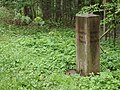
This is the category of the Bavarian Baudenkmal (cultural heritage monument) with the ID D-5-77-115-45 (Wikidata)
|
This is the category for an architectural monument.
It is on the list of cultural monuments of Bergen (Mittelfranken) OT Geyern, no. D-5-77-115-45.
It is on the list of cultural monuments of Bergen (Mittelfranken) OT Geyern, no. D-5-77-115-45.
Media in category "Bayrischer Kilometerstein (Geyern)"
The following 7 files are in this category, out of 7 total.
-
 Geyern, Bayrischer Kilometerstein (1).jpg 4,608 × 3,456; 6.64 MB
-
 Geyern, Bayrischer Kilometerstein (2).jpg 3,456 × 4,608; 6.73 MB
-
 Geyern, Bayrischer Kilometerstein (3).jpg 3,456 × 4,608; 6.4 MB
-
 Geyern, Bayrischer Kilometerstein (4).jpg 3,456 × 4,608; 6.56 MB
-
 Geyern, Bayrischer Kilometerstein (5).jpg 4,608 × 3,456; 6.22 MB
-
 Geyern, Bayrischer Kilometerstein (6).jpg 4,608 × 3,456; 6.76 MB
-
 Geyern, Bayrischer Kilometerstein (7).jpg 4,608 × 3,456; 6.56 MB
.jpg)
.jpg)
.jpg)
.jpg)
.jpg)
.jpg)