Category:Beaches of Devon
Wikimedia category | |||||
| Upload media | |||||
| Instance of | |||||
|---|---|---|---|---|---|
| |||||
This is a category containing media of beaches located in the county of Devon, England.
Subcategories
This category has the following 44 subcategories, out of 44 total.
A
- Ayrmer Cove (12 F)
B
- Barricane Beach (18 F)
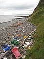
- Beach litter in Devon (20 F)
- Beer Beach, Devon (65 F)
- Bigbury-on-Sea Beach (31 F)
- Blackpool Sands, Dartmouth (45 F)
- Bovisand Bay, Devon (21 F)
C
- Challaborough Beach (15 F)
- Combe Martin Beach (22 F)
- Crow Point Light (2 F)
- Croyde Bay (50 F)
D
- Dawlish Warren Beach (114 F)
E
G
- Great Mattiscombe Sand (32 F)
I
- Instow Beach (18 F)
L
- Lannacombe Beach (24 F)
M
- Man Sands (66 F)
- Mill Bay, East Portlemouth (15 F)
N
- Ness Cove (18 F)
P
- Putsborough Sands (21 F)
R
- Rockham Beach (12 F)
S
- Saltern Cove (19 F)
- Scabbacombe Sands (56 F)
- Seaton Beach, Devon (47 F)
T
W
- Wembury Beach (19 F)
- Westward Ho! Beach (34 F)
- Wonwell Beach (6 F)
- Woolacombe Beach (113 F)
Media in category "Beaches of Devon"
The following 200 files are in this category, out of 769 total.
(previous page) (next page)-
 'Ben Varrey' beached on Burgh Island - geograph.org.uk - 340519.jpg 640 × 480; 53 KB
-

-
 2010-10-07-ladram bay east.jpg 2,048 × 1,536; 863 KB
-

-
 A local train enters Parsons Tunnel - geograph.org.uk - 1291516.jpg 640 × 480; 72 KB
-
 A panoramic view of Seaton promenade - geograph.org.uk - 1042875.jpg 640 × 480; 55 KB
-
 A view of Baggy Point - geograph.org.uk - 1325660.jpg 640 × 480; 50 KB
-
 A view to Potter's Hill - geograph.org.uk - 1327033.jpg 640 × 480; 122 KB
-
 Abbey River emerging on to Blegberry beach - August 2011 - panoramio.jpg 2,288 × 1,712; 854 KB
-
 Abbey River meets the sea at Blegberry Beach - Aug 2011 - panoramio.jpg 1,712 × 2,288; 1,000 KB
-
 Abbotsham Cliff - geograph.org.uk - 1302790.jpg 640 × 480; 234 KB
-
 Abbotsham Cliff - geograph.org.uk - 1302796.jpg 640 × 480; 123 KB
-
-
 Access to Combesgate Beach - geograph.org.uk - 1329745.jpg 640 × 480; 126 KB
-
 All aboard^ - geograph.org.uk - 1274190.jpg 468 × 640; 86 KB
-
 Along the prom at Seaton - geograph.org.uk - 815684.jpg 640 × 427; 202 KB
-
 Anglers on the beach at Buck's Mills - geograph.org.uk - 1387028.jpg 640 × 427; 79 KB
-
 Appledore across the water from Instow Sands - August 2011 - panoramio.jpg 2,288 × 1,712; 793 KB
-
 Appledore from Instow Sands - August 2011 - panoramio.jpg 2,288 × 1,712; 783 KB
-
 Approaching Dawlish Warren - geograph.org.uk - 1048817.jpg 640 × 434; 106 KB
-
 Avon Estuary - geograph.org.uk - 286524.jpg 640 × 480; 66 KB
-
 Baggy Point (7071771169).jpg 2,412 × 1,744; 1.81 MB
-
 Baggy Point from Woolacombe Beach - geograph.org.uk - 648993.jpg 640 × 275; 22 KB
-
 Baggy Point.JPG 2,845 × 1,140; 586 KB
-
 Baggy Point1.jpg 1,600 × 1,200; 178 KB
-
 Bantham Beach - geograph.org.uk - 1438587.jpg 640 × 426; 110 KB
-
 Bantham Beach - geograph.org.uk - 1590183.jpg 640 × 480; 55 KB
-
 Bantham Beach - geograph.org.uk - 426616.jpg 640 × 480; 73 KB
-
 Bantham beach geograph-4100103-by-Ben-Brooksbank.jpg 2,348 × 1,399; 4.67 MB
-
 Bantham Ham from Burgh Island - geograph.org.uk - 1475155.jpg 491 × 640; 71 KB
-
 Bantham Valley, Beach and Car Park - geograph.org.uk - 1435404.jpg 640 × 427; 91 KB
-
 Base of Abbotsham Cliff - geograph.org.uk - 1302743.jpg 640 × 480; 102 KB
-
 Batten Bay - geograph.org.uk - 1169560.jpg 640 × 427; 78 KB
-
 Batten Bay - geograph.org.uk - 1580428.jpg 640 × 480; 101 KB
-
 Beach - panoramio (90).jpg 2,448 × 2,448; 442 KB
-
 Beach - panoramio (91).jpg 2,125 × 2,833; 1.5 MB
-
 Beach - panoramio (96).jpg 3,181 × 2,027; 992 KB
-
 Beach - panoramio (98).jpg 3,264 × 2,448; 585 KB
-
 Beach access at Speke's Mill Mouth - geograph.org.uk - 506871.jpg 640 × 480; 157 KB
-
 Beach access, Croyde Bay - geograph.org.uk - 1325520.jpg 640 × 430; 68 KB
-
 Beach and headland, Outer Hope - geograph.org.uk - 730427.jpg 640 × 480; 66 KB
-
 Beach and rocks west of Wembury - geograph.org.uk - 1579404.jpg 640 × 480; 117 KB
-
 Beach at Charton Bay - geograph.org.uk - 1355930.jpg 640 × 480; 106 KB
-
 Beach at Hartland Quay - geograph.org.uk - 1416234.jpg 640 × 415; 49 KB
-
 Beach at Hartland Quay - geograph.org.uk - 1416235.jpg 640 × 427; 79 KB
-
 Beach at Hartland Quay - geograph.org.uk - 1416250.jpg 640 × 427; 72 KB
-
 Beach at Ilfracombe - geograph.org.uk - 1430477.jpg 480 × 640; 94 KB
-
 Beach at Lee Bay - geograph.org.uk - 1421688.jpg 640 × 480; 106 KB
-
 Beach at Sandy Bay - geograph.org.uk - 389103.jpg 640 × 480; 95 KB
-
 Beach below Bindon Cliffs - geograph.org.uk - 1355953.jpg 640 × 480; 95 KB
-
 Beach below Broad Cliff - geograph.org.uk - 2375491.jpg 640 × 446; 99 KB
-
 Beach below Haven Cliff, Seaton - geograph.org.uk - 1637557.jpg 640 × 427; 91 KB
-
 Beach below the High Land of Orcombe - geograph.org.uk - 930478.jpg 640 × 480; 76 KB
-
 Beach Cafe at Putsborough Sands - geograph.org.uk - 31823.jpg 640 × 461; 86 KB
-
 Beach Channel - geograph.org.uk - 221692.jpg 480 × 640; 94 KB
-
 Beach clean at Rockham beach in the sea mist.jpg 2,448 × 3,264; 2.2 MB
-
 Beach front, Instow - geograph.org.uk - 1345355.jpg 640 × 480; 161 KB
-
 Beach huts on sauton sands.jpg 4,000 × 3,000; 1.81 MB
-
 Beach near Langstone Rock - geograph.org.uk - 1288838.jpg 640 × 480; 103 KB
-

-
 Beach to Warren Point - geograph.org.uk - 1590190.jpg 640 × 480; 79 KB
-
 Beach west of Sharpland Point - geograph.org.uk - 1476877.jpg 480 × 640; 92 KB
-
 Beach west of Wembury.jpg 4,072 × 2,776; 4.72 MB
-
 Beached - geograph.org.uk - 1531295.jpg 640 × 428; 98 KB
-
 Beacon Beach - geograph.org.uk - 221938.jpg 640 × 480; 104 KB
-
 Beacon Cove, near Hope Cove - geograph.org.uk - 922304.jpg 640 × 480; 67 KB
-
 Beacon Point - geograph.org.uk - 510484.jpg 443 × 640; 69 KB
-
 Bee Sands and the cliffs northwards - geograph.org.uk - 84819.jpg 640 × 429; 117 KB
-
 Beesands - geograph.org.uk - 1490760.jpg 640 × 419; 60 KB
-
 Beesands and Start Bay - geograph.org.uk - 893043.jpg 640 × 362; 168 KB
-
 Beesands beach Stokenham - panoramio.jpg 4,000 × 3,000; 4.62 MB
-
 Beesands Facing North - geograph.org.uk - 16355.jpg 640 × 480; 77 KB
-
 Beesands Sea Defences - geograph.org.uk - 307158.jpg 640 × 427; 104 KB
-
 Beesands Sea Defences, Winter - geograph.org.uk - 314549.jpg 640 × 480; 86 KB
-
 Beesands, Devon - geograph.org.uk - 413584.jpg 640 × 480; 43 KB
-
 Bennett's Mouth - geograph.org.uk - 880233.jpg 640 × 427; 91 KB
-
 Beside the Seaside - geograph.org.uk - 1445335.jpg 640 × 426; 93 KB
-
 Bickwell Brook enters the sea - geograph.org.uk - 1580743.jpg 640 × 480; 110 KB
-
 Bight a Doubleyou - geograph.org.uk - 875397.jpg 640 × 427; 83 KB
-
 Black Pit - geograph.org.uk - 880375.jpg 640 × 427; 100 KB
-
 Black Rock - geograph.org.uk - 667196.jpg 640 × 376; 274 KB
-
 Black Stone - geograph.org.uk - 1472946.jpg 569 × 640; 120 KB
-

-
 Blackchurch Rock - geograph.org.uk - 1989.jpg 640 × 395; 44 KB
-

-
 Boat in the Taw estuary - geograph.org.uk - 1354709.jpg 640 × 480; 59 KB
-
 Boats beached at low tide - geograph.org.uk - 1354848.jpg 480 × 640; 57 KB
-
 Boats, Hallsands - geograph.org.uk - 1490716.jpg 640 × 460; 107 KB
-
 Boats, Hallsands - geograph.org.uk - 1490728.jpg 640 × 421; 88 KB
-
 Bonfire, Shaldon - geograph.org.uk - 1041923.jpg 640 × 480; 93 KB
-
 Boulder at Little Oddicombe Beach - geograph.org.uk - 675946.jpg 640 × 480; 112 KB
-
 Breakwater, Langstone Rocks - geograph.org.uk - 1116616.jpg 640 × 430; 60 KB
-
 Broad Sands - geograph.org.uk - 1399476.jpg 640 × 480; 94 KB
-
 Broad Sands - geograph.org.uk - 817844.jpg 640 × 425; 58 KB
-
 Broad Sands, Crow Point - geograph.org.uk - 717265.jpg 640 × 367; 175 KB
-
 Broadsands - geograph.org.uk - 71354.jpg 640 × 480; 91 KB
-
-

-
 Broadstrand Beach at Ilfracombe - geograph.org.uk - 1494235.jpg 640 × 434; 93 KB
-
 BSbeach.jpg 640 × 479; 85 KB
-
 Bucks Mills as seen from Clovelly - geograph.org.uk - 843064.jpg 640 × 426; 78 KB
-
 Bucks Mills Gut.JPG 3,264 × 2,448; 1.56 MB
-

-
 Bull Point - geograph.org.uk - 873152.jpg 640 × 427; 81 KB
-
 Burgh Island - geograph.org.uk - 1450055.jpg 640 × 480; 84 KB
-
 Burgh Island - geograph.org.uk - 371307.jpg 640 × 480; 105 KB
-
 Burgh Island - waterfront buildings - geograph.org.uk - 671010.jpg 640 × 284; 41 KB
-
 Burgh Island and sea tractor - geograph.org.uk - 417796.jpg 480 × 640; 211 KB
-

-
 Burgh Island Causeway - geograph.org.uk - 1733961.jpg 3,072 × 2,304; 2.84 MB
-

-
 Busy Autumn day on the beach - geograph.org.uk - 1562456.jpg 640 × 480; 95 KB
-
 Cairn at Hope's Nose Beach.jpg 5,152 × 3,864; 3.38 MB
-
 Capstone Hill, Ilfracombe (geograph 4148613).jpg 1,333 × 1,000; 1.15 MB
-
 Caravans above Hele Bay - geograph.org.uk - 1421681.jpg 640 × 480; 73 KB
-
 Carole, Sea 8.jpg 682 × 648; 103 KB
-
 Carpark by Wembury beach - geograph.org.uk - 1071556.jpg 640 × 480; 76 KB
-
 Charton Bay, Humble Pt - geograph.org.uk - 697115.jpg 640 × 480; 112 KB
-
 Chivelstone, Gammon Head - geograph.org.uk - 567829.jpg 640 × 422; 168 KB
-
 Chivelstone, Horsley Cove, East Prawle - geograph.org.uk - 951858.jpg 640 × 427; 206 KB
-
-
 Chivelstone, towards Sharpers Head - geograph.org.uk - 951860.jpg 640 × 427; 175 KB
-
 Cliffs above Ivy Cove.jpg 9,590 × 6,885; 70.25 MB
-
 Cliffs Above Little Beach (1).jpg 7,667 × 4,630; 38.4 MB
-
 Cliffs Above Little Beach (2).jpg 4,855 × 7,305; 37.93 MB
-
 Cliffs between Bigbury-on-Sea and Toby's Point - geograph.org.uk - 1733926.jpg 3,072 × 2,304; 2.67 MB
-
 Cliffs west of Sidmouth - geograph.org.uk - 27179.jpg 640 × 480; 56 KB
-
 Coastal defences, Beesands - geograph.org.uk - 69707.jpg 640 × 480; 130 KB
-

-
 Coastal view, Portledge Beach - geograph.org.uk - 417837.jpg 640 × 480; 75 KB
-
 Coastal wall at Lynmouth - geograph.org.uk - 939705.jpg 480 × 640; 102 KB
-
 Coastline at Northam Burrows - geograph.org.uk - 932020.jpg 640 × 480; 63 KB
-
 Coastline at Red Cove - geograph.org.uk - 1510979.jpg 640 × 439; 71 KB
-

-
 Coloured strata at Hartland Quay - geograph.org.uk - 1518518.jpg 640 × 427; 88 KB
-
-

-
 Combesgate Beach - geograph.org.uk - 1318118.jpg 640 × 473; 148 KB
-
 Compass Cove - geograph.org.uk - 41602.jpg 640 × 480; 211 KB
-
 Cornborough Cliff - geograph.org.uk - 1302807.jpg 640 × 480; 94 KB
-
 Cornborough cliff on a summer's day - geograph.org.uk - 130799.jpg 640 × 480; 83 KB
-
 Cornwall Beach - geograph.org.uk - 1700975.jpg 640 × 480; 78 KB
-

-
 Cove at Start Point - geograph.org.uk - 1335981.jpg 640 × 480; 238 KB
-
 Cove east of Elberry - geograph.org.uk - 1437787.jpg 640 × 480; 381 KB
-
 Crashing surf - geograph.org.uk - 1327459.jpg 640 × 451; 98 KB
-
 Crossing to Burgh Island - geograph.org.uk - 1507048.jpg 640 × 406; 74 KB
-
 Crownhill Bay - geograph.org.uk - 1271561.jpg 640 × 304; 49 KB
-
 Crownhill Bay.jpg 640 × 427; 117 KB
-
 Danger Point - geograph.org.uk - 1298649.jpg 640 × 480; 115 KB
-
 Dartmouth, steps to Castle Cove - geograph.org.uk - 750112.jpg 640 × 427; 197 KB
-
 Dawlish Railway Station - geograph.org.uk - 5857415.jpg 800 × 600; 715 KB
-

-
 Dawlish Warren , Coastline - geograph.org.uk - 1143669.jpg 640 × 480; 57 KB
-
 Dawlish Warren , Coastline - geograph.org.uk - 1143670.jpg 640 × 480; 45 KB
-

-
 Dawlish Warren , Langstone Rock - geograph.org.uk - 1143668.jpg 640 × 480; 58 KB
-
 Dawlish Warren , Langstone Rock - geograph.org.uk - 1143671.jpg 640 × 480; 46 KB
-
 Dawlish Warren , Langstone Rock - geograph.org.uk - 1237105.jpg 512 × 640; 55 KB
-
 Dawlish Warren , Langstone Rock - geograph.org.uk - 1237143.jpg 640 × 512; 71 KB
-
 Dawlish Warren , Langstone Rock - geograph.org.uk - 1237146.jpg 640 × 512; 75 KB
-

-

-
 Dawlish Warren , Sandy Coastline - geograph.org.uk - 1237082.jpg 640 × 512; 51 KB
-

-

-
 Dawlish Warren MMB 06 South Devon Main Line.jpg 2,331 × 1,332; 1.24 MB
-
 Dawlish Warren MMB 14 South Devon Main Line 159108.jpg 2,358 × 1,206; 1.1 MB
-
 Dawlish Warren MMB 15 South Devon Main Line 43098 43028.jpg 2,400 × 1,389; 1.49 MB
-
 Dawlish, Coryton's Cove - geograph.org.uk - 1564095.jpg 640 × 480; 61 KB
-
 De haven van Lundy.jpg 3,008 × 2,000; 4.02 MB
-
 Descent to Grunta Beach - geograph.org.uk - 876084.jpg 640 × 427; 88 KB
-
 Deserted (nearly) Beach - geograph.org.uk - 723750.jpg 640 × 480; 32 KB
-
 Devon Valley Holiday Village - Beach - geograph.org.uk - 609983.jpg 640 × 434; 84 KB
-
 Double Rainbow - geograph.org.uk - 918847.jpg 640 × 480; 88 KB
-
 Dowlands Cliffs and Beach - geograph.org.uk - 1355945.jpg 640 × 480; 122 KB
-
 Down to the beach, Buck's Mills - geograph.org.uk - 1596010.jpg 480 × 640; 94 KB
-
 Drainage Patterns - geograph.org.uk - 221945.jpg 640 × 480; 60 KB
-
 Dune line - geograph.org.uk - 1325685.jpg 640 × 480; 70 KB
-
 Dunes by the Torridge Estuary - geograph.org.uk - 932021.jpg 640 × 480; 53 KB
-
 East end of Sandy Bay - geograph.org.uk - 1339509.jpg 640 × 480; 239 KB
-
 East Portlemouth, ferry from Salcombe - geograph.org.uk - 1733982.jpg 3,072 × 2,304; 2.74 MB
-
 East Portlemouth, from Salcombe - geograph.org.uk - 1733975.jpg 3,072 × 2,304; 2.57 MB
-
 Elender Cove - geograph.org.uk - 645746.jpg 640 × 480; 104 KB
-
 Elender Cove - geograph.org.uk - 845905.jpg 640 × 480; 119 KB
-
 Endless Sands - geograph.org.uk - 325110.jpg 640 × 410; 45 KB
-
 Erme Estuary at Mothecombe 1.jpg 4,012 × 2,848; 2.71 MB
-
 Erme Estuary at Mothecombe 3.jpg 4,040 × 2,848; 2.72 MB
-
 Erme Estuary at Mothecombe 4.jpg 3,984 × 2,776; 2.52 MB
-
 Erme estuary from south.jpg 4,136 × 2,848; 2.59 MB
-
 Erme estuary from the east.jpg 3,880 × 2,848; 4.4 MB
-
 Erme Estuary pano.jpg 9,337 × 2,498; 6.21 MB
-
 Evening at Welcombe Mouth - geograph.org.uk - 1537440.jpg 640 × 427; 78 KB
-
 Evidence of fishing - geograph.org.uk - 1139547.jpg 424 × 640; 196 KB
-
 Expanse of sand - geograph.org.uk - 1302844.jpg 640 × 480; 46 KB
-
 Family on Newberry Beach - geograph.org.uk - 1318258.jpg 482 × 640; 123 KB
-
 Fernycombe Point - geograph.org.uk - 1511074.jpg 640 × 480; 100 KB
-
 Fishing at Beesands - geograph.org.uk - 1490816.jpg 640 × 463; 91 KB
-
 Flotsam below Cockington Cliff - geograph.org.uk - 1442513.jpg 480 × 640; 98 KB
-
 Focsle Inn, Combe Martin - geograph.org.uk - 1604212.jpg 640 × 480; 80 KB


.jpg)


.jpg)
.jpg)
.jpg)
.jpg)


.jpg)


.jpg)
.jpg)


_Beach_-_geograph.org.uk_-_723750.jpg)


