Category:Benchmarks in the City of Wakefield
Media in category "Benchmarks in the City of Wakefield"
The following 31 files are in this category, out of 31 total.
-
 1GL Bolt Bench Mark, St John's Church - geograph.org.uk - 5825863.jpg 1,024 × 683; 335 KB
-
 Bench mark, Kirkgate railway bridge - geograph.org.uk - 5835112.jpg 1,280 × 1,280; 611 KB
-
 Benchmark at corner of Westgate and Bank Street - geograph.org.uk - 3166639.jpg 683 × 1,024; 215 KB
-

-
 Benchmark on Castleford Bridge - geograph.org.uk - 3163602.jpg 2,048 × 1,536; 521 KB
-

-
 Benchmark on County Hall - geograph.org.uk - 3166851.jpg 683 × 1,024; 295 KB
-
 Benchmark on Graziers B^B Hotel - geograph.org.uk - 3167216.jpg 683 × 1,024; 314 KB
-
 Benchmark on school wall, Wentworth Street - geograph.org.uk - 3166885.jpg 683 × 1,024; 238 KB
-
 Benchmark on Sykes Bridge - geograph.org.uk - 3040825.jpg 2,048 × 1,536; 648 KB
-
 Benchmark on the Cathedral - geograph.org.uk - 3166819.jpg 742 × 1,024; 318 KB
-
 Benchmark on wall of Park Hill Walk - geograph.org.uk - 3168845.jpg 683 × 1,024; 261 KB
-
 Benchmark on Waller Bridge, Calder Grove - geograph.org.uk - 3039295.jpg 2,048 × 1,536; 733 KB
-
 Benchmark on ^142-148 Westgate - geograph.org.uk - 3166615.jpg 683 × 1,024; 109 KB
-
 Benchmark on ^18 King Street - geograph.org.uk - 3167041.jpg 683 × 1,024; 304 KB
-
 Benchmark on ^26 King Street - geograph.org.uk - 3166935.jpg 683 × 1,024; 253 KB
-
 Benchmark on ^41 George Street - geograph.org.uk - 3168538.jpg 683 × 1,024; 225 KB
-
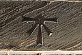
 Cut Bench Mark, Kirkgate railway bridge - geograph.org.uk - 5825913.jpg 1,024 × 683; 250 KB
-
 Cut Bench Mark, Margaret Street - geograph.org.uk - 5825852.jpg 1,024 × 683; 287 KB
-
 Cut Bench Mark, St Austin's Church - geograph.org.uk - 5825887.jpg 1,024 × 683; 234 KB
-
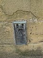
 Flush Bracket Bench Mark, Wakefield Cathedral - geograph.org.uk - 5825772.jpg 683 × 1,024; 269 KB
-
 Ordnance Survey Cut Mark - geograph.org.uk - 4007838.jpg 1,920 × 2,560; 3.04 MB
-
 Ordnance Survey Cut Mark - geograph.org.uk - 4120157.jpg 2,560 × 1,536; 1.56 MB
-
 Ordnance Survey Cut Mark - geograph.org.uk - 4120167.jpg 2,560 × 1,536; 2.08 MB
-
 Ordnance Survey Cut Mark - geograph.org.uk - 4120182.jpg 2,560 × 1,536; 2.24 MB
-
 Ordnance Survey Flush Bracket S0528 - geograph.org.uk - 4007882.jpg 1,920 × 2,560; 3.19 MB
-
 Ordnance Survey Flush Bracket S9043 - geograph.org.uk - 2808113.jpg 4,000 × 3,000; 4.1 MB
-
 Ordnance Survey Flush Bracket S9044 - geograph.org.uk - 4035522.jpg 4,000 × 3,000; 2.81 MB
-
 Road sign - geograph.org.uk - 927300.jpg 480 × 640; 119 KB
-
 St Giles church benchmark - geograph.org.uk - 4190541.jpg 1,024 × 768; 241 KB
-
 Unusual road sign - geograph.org.uk - 927291.jpg 480 × 640; 110 KB


