Category:Bendochy
Scottish parish in Perth and Kinross, Scotland, UK | |||||
| Upload media | |||||
| Instance of | |||||
|---|---|---|---|---|---|
| Location |
| ||||
| Population |
| ||||
| Area |
| ||||
 | |||||
Media in category "Bendochy"
The following 200 files are in this category, out of 242 total.
(previous page) (next page)-
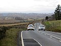 A926 - geograph.org.uk - 3870499.jpg 640 × 480; 217 KB
-
 A926, Pictfield - geograph.org.uk - 4025795.jpg 640 × 480; 319 KB
-
 A984 - geograph.org.uk - 5945888.jpg 1,024 × 683; 326 KB
-
 Alyth Burn and Welton of Creuchies - geograph.org.uk - 3605338.jpg 640 × 480; 64 KB
-
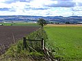
 Arable land near Blairgowrie - geograph.org.uk - 4119600.jpg 640 × 480; 280 KB
-
 Arable land near Blairgowrie - geograph.org.uk - 5945894.jpg 1,024 × 683; 406 KB
-
 Arable land near Rosemount - geograph.org.uk - 2624372.jpg 640 × 480; 74 KB
-
 Arable land, Bendochy - geograph.org.uk - 4024506.jpg 640 × 480; 261 KB
-
 Arable land, Ryehill - geograph.org.uk - 3868241.jpg 640 × 480; 228 KB
-
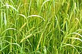
 Barley field at West Tullyfergus - geograph.org.uk - 3605327.jpg 640 × 480; 70 KB
-
 Barley growing near Ryehill - geograph.org.uk - 902102.jpg 426 × 640; 69 KB
-
 Barley, Draffin - geograph.org.uk - 4119594.jpg 640 × 480; 248 KB
-
 Barley, near Coupar Grange - geograph.org.uk - 2502962.jpg 800 × 534; 268 KB
-
 Bench Mark, Bridge of Couttie - geograph.org.uk - 2693497.jpg 640 × 480; 90 KB
-
 Bend on the Ericht - geograph.org.uk - 1832552.jpg 2,304 × 1,728; 1.85 MB
-
 Bendochy Parish Kirk - geograph.org.uk - 862853.jpg 640 × 480; 114 KB
-
 Berry picker's camp, Rosemount - geograph.org.uk - 3869217.jpg 640 × 480; 242 KB
-
 Birch sapling growing in a fencepost, Monk Myre - geograph.org.uk - 3581421.jpg 681 × 1,024; 231 KB
-
 Black Law - geograph.org.uk - 4025797.jpg 640 × 480; 261 KB
-
 Bridge of Couttie, Coupar Angus - geograph.org.uk - 2693555.jpg 640 × 481; 97 KB
-
 Bridge over the Alyth Burn - geograph.org.uk - 3605294.jpg 640 × 480; 122 KB
-
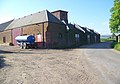
 Buildings near West Tullyfergus - geograph.org.uk - 1104674.jpg 640 × 427; 226 KB
-
 Burn passing Thorn - geograph.org.uk - 3870490.jpg 640 × 480; 380 KB
-
 Carr woodland, Monk Myre - geograph.org.uk - 3581424.jpg 1,024 × 682; 286 KB
-

-
 Cereal crop near Rosemount - geograph.org.uk - 2624360.jpg 640 × 480; 77 KB
-
 Cereals, Easter Monkmyre - geograph.org.uk - 3868267.jpg 640 × 480; 250 KB
-
 Chapelhill - geograph.org.uk - 3870867.jpg 640 × 360; 215 KB
-
 Chapelton Farm from Hill of St Fink - geograph.org.uk - 3603539.jpg 1,024 × 681; 197 KB
-
 Churchyard, Bendochy Kirk - geograph.org.uk - 863015.jpg 640 × 480; 130 KB
-
 Churchyard, Bendochy Kirk - geograph.org.uk - 863033.jpg 640 × 480; 101 KB
-
 Clocktower, Coupar Grange Farm - geograph.org.uk - 863053.jpg 640 × 480; 68 KB
-
 Clydesdale, West Myreriggs - geograph.org.uk - 2624466.jpg 640 × 480; 68 KB
-

-
 Coot (Fulica atra), Monk Myre - geograph.org.uk - 1803765.jpg 800 × 533; 65 KB
-
 Cottage at East Tullyfergus - geograph.org.uk - 5850558.jpg 5,184 × 3,888; 5.7 MB
-
 Coupar Grange Farm - geograph.org.uk - 863043.jpg 640 × 449; 84 KB
-
 Couttie Law - geograph.org.uk - 896719.jpg 640 × 426; 81 KB
-

-
 East Myreriggs Farm - geograph.org.uk - 863091.jpg 640 × 474; 99 KB
-
 Easter Bendochy - geograph.org.uk - 3868216.jpg 640 × 480; 250 KB
-
 Embankment, Blairgowrie Branch - geograph.org.uk - 5945883.jpg 1,024 × 683; 357 KB
-
 Ericht-Isla floodplain - geograph.org.uk - 3870860.jpg 640 × 360; 213 KB
-
 Ewe and lambs near Bamff - geograph.org.uk - 2629615.jpg 640 × 480; 76 KB
-
 Farm access, East Tullyfergus - geograph.org.uk - 3870167.jpg 640 × 480; 353 KB
-
 Farm buildings at Mains of Creuchies - geograph.org.uk - 3605289.jpg 640 × 480; 74 KB
-
 Farm buildings at Mains of Creuchies - geograph.org.uk - 3605298.jpg 640 × 480; 68 KB
-
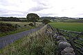
 Farm road, Aberbothrie - geograph.org.uk - 4025801.jpg 640 × 480; 262 KB
-
 Farm track leading to Red Brae - geograph.org.uk - 6202954.jpg 4,000 × 3,000; 3.65 MB
-
 Farmhouse, East Tullyfergus - geograph.org.uk - 1104651.jpg 417 × 640; 244 KB
-
 Fence and bath near Tullymurdoch - geograph.org.uk - 2627833.jpg 640 × 480; 73 KB
-
 Feus of Pictfield from the Ericht at Aberbothrie - geograph.org.uk - 3286740.jpg 1,024 × 681; 155 KB
-
 Field near Creuchies - geograph.org.uk - 5850593.jpg 5,184 × 3,888; 5.05 MB
-
 Field near the Bridge of Tully - geograph.org.uk - 3605379.jpg 640 × 480; 108 KB
-

-
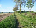
 Field, East Tullyfergus - geograph.org.uk - 3870174.jpg 640 × 480; 288 KB
-
 Fields near Aberbothrie - geograph.org.uk - 3715321.jpg 1,024 × 681; 182 KB
-
 Fields near Monk Myre - geograph.org.uk - 4298712.jpg 1,024 × 681; 134 KB
-
 Fishing Lochan - geograph.org.uk - 5850587.jpg 5,184 × 3,888; 6.34 MB
-
 Fishing pond north of Drimmie Woods - geograph.org.uk - 3604966.jpg 640 × 480; 85 KB
-
 Flood in barley field near Coupar Grange - geograph.org.uk - 2502949.jpg 800 × 534; 186 KB
-
 Flood plain, Aberbothrie - geograph.org.uk - 3870863.jpg 640 × 360; 191 KB
-
 Flood plain, Aberbothrie - geograph.org.uk - 3870864.jpg 640 × 360; 177 KB
-
 Flooded field, Rosemount - geograph.org.uk - 1803787.jpg 800 × 534; 225 KB
-
 Floods along the Isla at Bardmony bridge - geograph.org.uk - 3289393.jpg 1,024 × 626; 132 KB
-
 Floods along the Isla at Bardmony bridge - geograph.org.uk - 3289402.jpg 1,024 × 682; 148 KB
-
 Floods at Aberbothrie - geograph.org.uk - 3289518.jpg 1,024 × 679; 106 KB
-
 Floods beside the track to Boglea, Aberbothrie - geograph.org.uk - 3289383.jpg 1,024 × 681; 169 KB
-
 Flush Bracket 11540, Moorfield Hotel - geograph.org.uk - 1854691.jpg 480 × 640; 184 KB
-
 Footpath from St Fink to Drimmie Woods - geograph.org.uk - 1101286.jpg 426 × 640; 107 KB
-
 Footpath near Hill of St Fink - geograph.org.uk - 2413699.jpg 1,600 × 1,200; 756 KB
-
 Forestry access, West Tullyfergus - geograph.org.uk - 3870034.jpg 640 × 480; 320 KB
-

-
 Forestry on the Tullyfergus Estate - geograph.org.uk - 1091742.jpg 640 × 426; 77 KB
-
 Forestry on the Tullyfergus Estate - geograph.org.uk - 1091746.jpg 640 × 426; 94 KB
-
 Freshly cut fields - geograph.org.uk - 6601529.jpg 4,032 × 1,960; 4.36 MB
-
 Frozen Tree - geograph.org.uk - 1652622.jpg 427 × 640; 64 KB
-
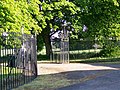 Gates to Coupar Grange - geograph.org.uk - 863050.jpg 640 × 480; 149 KB
-
 Grass field, Couttie - geograph.org.uk - 4119066.jpg 640 × 480; 255 KB
-
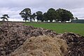
 Ground working, Creuchies - geograph.org.uk - 5949682.jpg 1,024 × 683; 205 KB
-
 Head of the Den of Welton - geograph.org.uk - 906485.jpg 640 × 426; 59 KB
-
 Head of the Den of Welton - geograph.org.uk - 909932.jpg 640 × 426; 140 KB
-
 Hill of St Fink - geograph.org.uk - 1101266.jpg 640 × 426; 63 KB
-
 Hills of Bendochy - geograph.org.uk - 896715.jpg 640 × 426; 70 KB
-
 Hilltop copse - geograph.org.uk - 3605253.jpg 640 × 480; 82 KB
-
 Hilltop near Creuchies - geograph.org.uk - 1112155.jpg 640 × 426; 98 KB
-
 Hilltop near Creuchies in autumn - geograph.org.uk - 1009511.jpg 640 × 426; 54 KB
-
 Hilltop trees - geograph.org.uk - 5949664.jpg 1,024 × 683; 443 KB
-
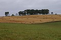
 Hilltop trees near Creuchies - geograph.org.uk - 2629545.jpg 640 × 480; 76 KB
-
 Kitty Swanson's Bridge - geograph.org.uk - 863305.jpg 640 × 480; 114 KB
-
 Kitty Swanson's Bridge, near Blairgowrie - geograph.org.uk - 3286711.jpg 1,024 × 681; 327 KB
-
 Kitty Swanson's Bridge, near Blairgowrie - geograph.org.uk - 3286713.jpg 1,024 × 681; 242 KB
-
 Kitty Swanson's Bridge, near Blairgowrie - geograph.org.uk - 3286724.jpg 1,024 × 681; 307 KB
-
 Kitty Swansons Bridge.jpg 1,777 × 2,360; 2.92 MB
-
 Little Monk Myre - geograph.org.uk - 3286707.jpg 1,024 × 681; 159 KB
-
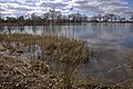
 Lochan - geograph.org.uk - 5949661.jpg 1,024 × 683; 252 KB
-
 Lochlands farm - geograph.org.uk - 1832560.jpg 1,024 × 768; 156 KB
-
 Looking back towards Ardler and Meigle - geograph.org.uk - 1146708.jpg 640 × 480; 121 KB
-
 Looking towards the Isla at Bendochy - geograph.org.uk - 896723.jpg 640 × 426; 52 KB
-
 Mains of Creuchies - geograph.org.uk - 3605285.jpg 640 × 480; 84 KB
-
 Mains of Creuchies - geograph.org.uk - 5850597.jpg 5,184 × 3,888; 4.49 MB
-
 McSourie's Den - geograph.org.uk - 3870025.jpg 640 × 480; 269 KB
-
 Minor road and Bridge of Tully crossing Alyth Burn - geograph.org.uk - 6199109.jpg 4,000 × 3,000; 4.03 MB
-
 Minor road approaching Mains of Creuchies - geograph.org.uk - 6196526.jpg 4,000 × 3,000; 3.66 MB
-
 Minor road at Easter Bendochy - geograph.org.uk - 6202963.jpg 4,000 × 3,000; 3.34 MB
-
 Minor road at Easter Bendochy - geograph.org.uk - 6202964.jpg 4,000 × 3,000; 3.3 MB
-
 Minor road at Knowehead Cottage and Farm - geograph.org.uk - 6202960.jpg 4,000 × 3,000; 4.31 MB
-
 Minor road at Model Cottages - geograph.org.uk - 6202966.jpg 4,000 × 3,000; 4.28 MB
-
 Minor road between Bothrie and Burnhead - geograph.org.uk - 6199980.jpg 4,000 × 3,000; 2.94 MB
-
 Minor road heading in the direction of Mains of Creuchies - geograph.org.uk - 6196519.jpg 4,000 × 3,000; 3.14 MB
-
 Minor road heading towards Heatheryhaugh - geograph.org.uk - 6196512.jpg 4,000 × 3,000; 2.77 MB
-
 Minor road near Monkmyre - geograph.org.uk - 3868262.jpg 640 × 480; 278 KB
-
 Minor road, Blacklaw - geograph.org.uk - 3870528.jpg 640 × 480; 250 KB
-
 Minor road, Coupargrange - geograph.org.uk - 3868247.jpg 640 × 480; 284 KB
-

-
 Mixed farming, West Tullyfergus - geograph.org.uk - 1540206.jpg 640 × 480; 142 KB
-
 Mixed farming, West Tullyfergus - geograph.org.uk - 1548479.jpg 640 × 480; 145 KB
-
 Monk Myre - geograph.org.uk - 1803747.jpg 800 × 533; 97 KB
-
 Monk Myre - geograph.org.uk - 1803768.jpg 800 × 534; 216 KB
-
 Monk Myre - geograph.org.uk - 3286708.jpg 1,024 × 681; 195 KB
-
 Monk Myre - geograph.org.uk - 3581422.jpg 1,024 × 682; 158 KB
-
 Monk Myre from Rosemount - geograph.org.uk - 3286694.jpg 1,024 × 655; 173 KB
-
 Monk Myre from Rosemount - geograph.org.uk - 3286697.jpg 1,024 × 681; 119 KB
-
 Monk Myre, near Blairgowrie - geograph.org.uk - 4298713.jpg 1,024 × 681; 202 KB
-
 Monk Myre, Rosemount - geograph.org.uk - 3412842.jpg 1,024 × 682; 261 KB
-
 Monk Myre, Rosemount - geograph.org.uk - 3412845.jpg 1,024 × 682; 295 KB
-
 Monk Myre, Rosemount - geograph.org.uk - 3412849.jpg 1,024 × 682; 178 KB
-
 Moorfield Hotel - geograph.org.uk - 649366.jpg 640 × 425; 70 KB
-
 Moorfield Hotel - geograph.org.uk - 863082.jpg 640 × 480; 66 KB
-
 Myreriggs Road - geograph.org.uk - 4119596.jpg 800 × 600; 487 KB
-
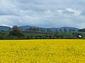
 Oil Seed Rape, Vale of Strathmore - geograph.org.uk - 2132432.jpg 3,648 × 2,736; 2.18 MB
-
 Oilseed rape near Rosemount - geograph.org.uk - 2455164.jpg 640 × 480; 69 KB
-

-
 Old railway bridge over River Isla - geograph.org.uk - 3966608.jpg 800 × 600; 88 KB
-
 On Kitty Swanson's Bridge - geograph.org.uk - 863312.jpg 640 × 480; 125 KB
-
 On the left bank of the River Ericht - geograph.org.uk - 4429933.jpg 2,048 × 1,536; 1.62 MB
-
 Orange sheep, East Tullyfergus - geograph.org.uk - 1548442.jpg 640 × 480; 198 KB
-
 Path to Kitty Swanson's Bridge - geograph.org.uk - 863104.jpg 640 × 504; 134 KB
-
 Path to Kitty Swanson's Bridge - geograph.org.uk - 863273.jpg 640 × 461; 111 KB
-
 Path to the River Ericht - geograph.org.uk - 863275.jpg 640 × 441; 115 KB
-
-
 Poly-tunnel framing - geograph.org.uk - 5960489.jpg 2,000 × 1,337; 2.1 MB
-
 Polytunnel frames - geograph.org.uk - 3870501.jpg 640 × 480; 249 KB
-
 Pond between Bamff and Drimmie - geograph.org.uk - 896146.jpg 640 × 426; 62 KB
-
 Pond between Bamff and Drimmie - geograph.org.uk - 913645.jpg 640 × 426; 94 KB
-

-
 Pond near Tullymurdoch - geograph.org.uk - 1540283.jpg 640 × 481; 135 KB
-
 Pond near Tullymurdoch - geograph.org.uk - 2627828.jpg 640 × 480; 80 KB
-
 Ponies near the Bridge of Tully - geograph.org.uk - 2630465.jpg 480 × 640; 68 KB
-
 Pony by the River Ericht - geograph.org.uk - 863277.jpg 640 × 480; 155 KB
-
 Potato fields near Coupar Angus - geograph.org.uk - 862836.jpg 640 × 456; 86 KB
-
 Railway embankment - geograph.org.uk - 3867237.jpg 640 × 480; 282 KB
-

-

-
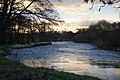
 River Ericht - geograph.org.uk - 1832533.jpg 2,304 × 1,728; 1.83 MB
-
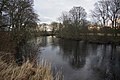
 River Ericht at Aberbothrie - geograph.org.uk - 3286730.jpg 1,024 × 681; 186 KB
-
 River Ericht at Mains of Rattray - geograph.org.uk - 3287840.jpg 1,024 × 681; 223 KB
-
 River Ericht at Mains of Rattray - geograph.org.uk - 3287857.jpg 1,024 × 681; 220 KB
-

-
 River Ericht path - geograph.org.uk - 1831256.jpg 2,304 × 1,728; 1.41 MB
-
 River Isla - geograph.org.uk - 3868224.jpg 640 × 480; 256 KB
-

-
 River Isla, Coupar Angus - geograph.org.uk - 2693477.jpg 640 × 481; 72 KB
-
 Road closed at Bardmony Bridge, near Alyth - geograph.org.uk - 3802791.jpg 1,024 × 681; 206 KB
-
 Road junction, Easter Myreriggs - geograph.org.uk - 3868263.jpg 640 × 480; 231 KB
-
 Road, Bendochy - geograph.org.uk - 3867265.jpg 640 × 480; 330 KB
-
 Road, Creuchies - geograph.org.uk - 5949685.jpg 1,024 × 683; 340 KB
-
 Road, West Grange of Aberbothrie - geograph.org.uk - 3870859.jpg 640 × 360; 186 KB
-
 Roadside verge at Ryehill - geograph.org.uk - 902098.jpg 640 × 426; 122 KB
-
 Roe deer near New Alyth - geograph.org.uk - 2630723.jpg 640 × 480; 76 KB
-
 Shaded track at Ryehill - geograph.org.uk - 902084.jpg 640 × 461; 76 KB
-

-

-
 Sheep, Creuchies - geograph.org.uk - 5949668.jpg 1,024 × 683; 287 KB
-
 Shepherd in a Land Rover - geograph.org.uk - 2629581.jpg 640 × 480; 87 KB
-

-

-
 Spurs, Hill of St Fink - geograph.org.uk - 3870012.jpg 640 × 480; 266 KB
-
 Static caravans beside dirt road - geograph.org.uk - 5960488.jpg 2,000 × 1,500; 2.46 MB
-
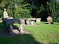
 Stone Family - geograph.org.uk - 2375899.jpg 1,600 × 1,071; 572 KB
-
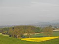
 Strathmore - geograph.org.uk - 3870866.jpg 640 × 360; 200 KB
-
 Strathmore arable - geograph.org.uk - 3870494.jpg 640 × 480; 267 KB
-
 Strathmore arable land - geograph.org.uk - 3868254.jpg 640 × 480; 271 KB
-
 Strathmore arable land - geograph.org.uk - 3870522.jpg 640 × 480; 244 KB
-
 Strawberry field, Rosemount - geograph.org.uk - 3868272.jpg 640 × 480; 336 KB
-
 Stubble, Creuchies - geograph.org.uk - 5949673.jpg 1,024 × 683; 272 KB
-
 Stubble, Easter Bendochy - geograph.org.uk - 3868232.jpg 640 × 480; 258 KB
-
 Stubble, Strathmore - geograph.org.uk - 3870861.jpg 640 × 360; 201 KB
-

-
 Swans, Bendochy - geograph.org.uk - 3867256.jpg 640 × 480; 240 KB
-
 Telephone box near Easter Bendochy - geograph.org.uk - 1542374.jpg 640 × 480; 106 KB
-
 Telephone box, Bendochy - geograph.org.uk - 3868228.jpg 640 × 480; 258 KB
-
 The demise of the Moorfield Hotel - geograph.org.uk - 3171673.jpg 3,264 × 2,448; 1.36 MB
-
 The farm at St Fink from above Hill of St Fink - geograph.org.uk - 3413160.jpg 1,024 × 681; 148 KB
-

-

-

-

-

-
 The remains of the Moorfield Hotel - geograph.org.uk - 3171663.jpg 3,264 × 2,448; 1.32 MB


_on_a_fence,_Monk_Myre_-_geograph.org.uk_-_3929781.jpg)
,_Monk_Myre_-_geograph.org.uk_-_1803765.jpg)


,_near_Coupar_Grange_-_geograph.org.uk_-_2502959.jpg)


