Category:Berkeley Earth diagrams of Europe
Media in category "Berkeley Earth diagrams of Europe"
The following 21 files are in this category, out of 21 total.
-
 Aaland Temp (1750-2013)BE.jpg 2,380 × 1,818; 1.07 MB
-
 Austria Temp (1750-2013).jpg 2,374 × 1,810; 1,004 KB
-
 Austria-TAVG-Trend.svg 1,024 × 640; 466 KB
-
 Belarus Temp (1750-2013)BE.jpg 2,378 × 1,814; 1.06 MB
-
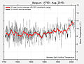 Belgium Temp (1750-2013)BE.jpg 2,374 × 1,812; 1.06 MB
-
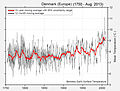 Denmark (1750-2013)BE.jpg 2,376 × 1,810; 1.02 MB
-
 Deutschland Temp (1750-2013).jpg 2,374 × 1,810; 1.04 MB
-
 Estonia Temp (1750-2013)BE.jpg 2,382 × 1,812; 1.08 MB
-
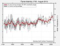 Faroe Islands Temp (1750-2013)BE.jpg 2,374 × 1,810; 1 MB
-
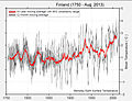 Finland Temp (1750-2013)BE.jpg 2,376 × 1,816; 1.12 MB
-
 Germany-TAVG-Trend 1743-2013.svg 1,024 × 640; 466 KB
-
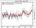 Iceland Temp (1750-2013)BE.jpg 2,376 × 1,816; 1.01 MB
-
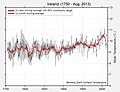 Ireland (1750-2013)BE.jpg 2,374 × 1,812; 1,002 KB
-
 Latvia Temp (1750-2013)BE.jpg 2,376 × 1,808; 1.01 MB
-
 Lithuania Temp (1750-2013)BE.jpg 2,372 × 1,814; 1.06 MB
-
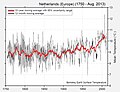 Netherlands Temp (1750-2013)BE.jpg 2,374 × 1,812; 1.05 MB
-
 Poland Temp (1750-2013)BE.jpg 2,378 × 1,816; 1.08 MB
-
 Sweden Temp (1750-2013)BE.jpg 2,378 × 1,814; 1.09 MB
-
 Switzerland Temp (1750-2013).jpg 2,378 × 1,816; 1.1 MB
-
 Switzerland-TAVG-Trend.svg 1,024 × 640; 466 KB
-
 United Kingdom (1750-2013)BE.jpg 2,374 × 1,812; 1.01 MB
BE.jpg)
.jpg)

BE.jpg)
BE.jpg)
BE.jpg)
.jpg)
BE.jpg)
BE.jpg)
BE.jpg)

BE.jpg)
BE.jpg)
BE.jpg)
BE.jpg)
BE.jpg)
BE.jpg)
BE.jpg)
.jpg)

BE.jpg)