Category:Birkfelder Straße 6, Anger
| Object location | | View all coordinates using: OpenStreetMap |
|---|
building in Anger, Austria  | |||||
| Upload media | |||||
| Instance of | |||||
|---|---|---|---|---|---|
| Location | Anger, Weiz District, Styria, Austria | ||||
| Street address |
| ||||
| Heritage designation | |||||
 | |||||
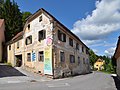
English: Anger Styria, residential building Birkfelder Straße 6
Deutsch: Anger Wohnhaus Birkfelderstraße 6
Media in category "Birkfelder Straße 6, Anger"
The following 4 files are in this category, out of 4 total.
-
 Anger Wohnhaus Birkfelderstrasse 6.JPG 6,000 × 4,000; 10.9 MB
-
 Birkfelder Straße 5,6 Anger.jpg 3,872 × 2,914; 3.59 MB
-
 Residential building Birkfelder Straße 6, Anger 02.jpg 4,472 × 3,152; 5.7 MB
-
 Residential building Birkfelder Straße 6, Anger 03.jpg 4,760 × 3,176; 5.68 MB


