Category:Black Range (New Mexico)
mountain range in Sierra, Grant, and Catron counties in New Mexico, United States  | |||||
| Upload media | |||||
| Instance of | |||||
|---|---|---|---|---|---|
| Location |
| ||||
| Elevation above sea level |
| ||||
 | |||||
English: Media related to the Black Range (also called the Devil's Mountains or Sierra Diablo), an igneous mountain range running north–south in Sierra, Grant, and Catron counties in Mexico, United States.
Subcategories
This category has the following 16 subcategories, out of 16 total.
B
- Beaver Creek (New Mexico) (15 F)
- Burnt Cabin Flat (3 F)
C
- Carbonate Canyon (7 F)
- Corduroy Canyon (12 F)
D
- Diamond Creek (New Mexico) (15 F)
- Doagy Canyon (6 F)
E
- East Canyon (Black Range) (8 F)
- Emory Pass (8 F)
F
- Flora of the Black Range (85 F)
G
- Gallinas Canyon (10 F)
H
Q
- Quaking Aspen Canyon Trail (7 F)
S
- Scales Canyon (5 F)
- Straight Gulch (15 F)
Media in category "Black Range (New Mexico)"
The following 38 files are in this category, out of 38 total.
-
 Adams Canyon - Flickr - aspidoscelis.jpg 3,600 × 2,400; 3.51 MB
-
 East of Beaverhead - Flickr - aspidoscelis (1).jpg 3,600 × 2,400; 4.3 MB
-
 East of Beaverhead - Flickr - aspidoscelis (2).jpg 3,600 × 2,400; 4.17 MB
-
 East of Beaverhead - Flickr - aspidoscelis.jpg 3,600 × 2,400; 4.48 MB
-
 East of Kemp Mesa - Flickr - aspidoscelis.jpg 3,600 × 2,400; 3.87 MB
-
 Gallinas-Canyon-viewed-from-152.jpg 1,080 × 836; 781 KB
-
 Geronimo Trail Scenic Byway - Devil's Backbone geologic area - NARA - 7718605.jpg 3,544 × 2,401; 7.71 MB
-
 Geronimo Trail Scenic Byway - Looking Across the Beaverhead Valley - NARA - 7718609.jpg 3,532 × 2,365; 6.7 MB
-
 Geronimo Trail Scenic Byway - Scenic Black Range Drive - NARA - 7718603.jpg 3,562 × 2,359; 6.54 MB
-
 Hardcastle Canyon - Flickr - aspidoscelis.jpg 4,000 × 1,800; 4.58 MB
-
 June10 across from Wrights Cabin (9049021483).jpg 2,592 × 1,936; 1.8 MB
-
 Leptinotarsa - Flickr - aspidoscelis (1).jpg 3,600 × 2,400; 2.2 MB
-
 Leptinotarsa - Flickr - aspidoscelis.jpg 3,600 × 2,400; 2.26 MB
-
 Monument Park - Flickr - aspidoscelis.jpg 3,600 × 2,400; 4.33 MB
-
 Near Adams Canyon - Flickr - aspidoscelis.jpg 3,600 × 2,400; 3.78 MB
-
 Near Adobe Canyon - Flickr - aspidoscelis (1).jpg 3,600 × 2,400; 3.69 MB
-
 Near Adobe Canyon - Flickr - aspidoscelis (2).jpg 3,600 × 2,400; 4 MB
-
 Near Adobe Canyon - Flickr - aspidoscelis.jpg 3,600 × 2,400; 3.86 MB
-
 Near Animas Peak - Flickr - aspidoscelis.jpg 3,600 × 2,400; 4.28 MB
-
 Near Diamond Creek - Flickr - aspidoscelis.jpg 3,600 × 2,400; 3.8 MB
-
 Near East Water Canyon - Flickr - aspidoscelis (1).jpg 3,600 × 2,400; 4.39 MB
-
 Near East Water Canyon - Flickr - aspidoscelis (2).jpg 3,600 × 2,400; 3.58 MB
-
 Near East Water Canyon - Flickr - aspidoscelis.jpg 3,600 × 2,400; 4.49 MB
-
 Near Indian Creek - Flickr - aspidoscelis (3).jpg 3,600 × 2,400; 4.06 MB
-
 Near Kemp Mesa - Flickr - aspidoscelis.jpg 3,600 × 2,400; 4.29 MB
-
 Near Seventyfour Draw - Flickr - aspidoscelis (10).jpg 3,600 × 2,400; 4.6 MB
-
 Near the Continental Divide Trail - Flickr - aspidoscelis (12).jpg 3,600 × 2,400; 4.09 MB
-
 New Mexico - Black Mountains - NARA - 68144781.jpg 5,460 × 7,002; 6.99 MB
-
 New Mexico - Black Mountains - NARA - 68144783.jpg 5,460 × 7,118; 6 MB
-
 New Mexico - Black Mountains - NARA - 68144785.jpg 5,460 × 7,118; 5.5 MB
-
 New Mexico - Black Mountains - NARA - 68144787.jpg 5,460 × 7,118; 6.12 MB
-
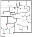 NMMap-doton-BlackMtns.png 200 × 230; 1 KB
-
 North of Beaverhead - Flickr - aspidoscelis.jpg 3,600 × 2,400; 3.49 MB
-
 Paramount - Taylor Divide - Flickr - aspidoscelis (1).jpg 3,600 × 2,400; 3.72 MB
-
 Rabb Park Trail - Flickr - aspidoscelis (4).jpg 3,600 × 2,400; 4.42 MB
-
 Sawyers Peak - Flickr - aspidoscelis.jpg 1,800 × 1,200; 1.13 MB
-
 Silver Fire June 21, 2013 (9109722107).jpg 3,264 × 2,448; 2.36 MB
-
 West of Burnt Cabin Flat - Flickr - aspidoscelis.jpg 3,600 × 2,400; 3.94 MB

.jpg)
.jpg)


.jpg)
.jpg)


.jpg)
.jpg)


.jpg)
.jpg)

.jpg)

.jpg)
.jpg)


.jpg)
.jpg)

.jpg)
