Category:Black Rock Harbor Lighthouse
| Object location | | View all coordinates using: OpenStreetMap |
|---|
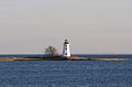
lighthouse in Connecticut, United States  Black Rock Harbor Light in 2005 | |||||
| Upload media | |||||
| Instance of | |||||
|---|---|---|---|---|---|
| Made from material |
| ||||
| Location |
| ||||
| Service retirement |
| ||||
| Inception |
| ||||
| Height |
| ||||
 | |||||
English: Black Rock Harbor Light, also know as Fayerweather Island Lighthouse. Located in Seaside Park on Fayerweather Island, beyond the end of Barnum Avenue, in Bridgeport.
Media in category "Black Rock Harbor Lighthouse"
The following 10 files are in this category, out of 10 total.
-

-
 Black Rock Harbor Light nowadays photo by Ting Xu.jpeg 1,440 × 960; 733 KB
-
 Black Rock Harbor Light.jpg 356 × 465; 25 KB
-
 Black Rock Harbor Lighthouse.JPG 3,258 × 2,151; 2.29 MB
-
 BridgeportCT BlackRockHarborLightFromPenfieldBeach.jpg 1,024 × 680; 125 KB
-
 Fayerweather Lighthouse Bridgeport, Connecticut 1906.jpg 550 × 357; 32 KB
-
 Lighthouse Seaside Park Bridgeport Connecticut - panoramio.jpg 2,560 × 1,920; 602 KB
-
 Seaside Park Lighthouse in Bridgeport, Connecticut LCCN2012630315.tif 5,718 × 3,815; 124.85 MB
-
 Seaside Park Lighthouse in Bridgeport, Connecticut LCCN2012630316.tif 6,144 × 4,096; 144.03 MB
-
 USCGC Kathleen Moore (WPC 1109) CoA.jpg 2,106 × 2,106; 441 KB
,_Published_1857.jpg)


_CoA.jpg)