Category:Blackshaw Hill

Media in category "Blackshaw Hill"
The following 11 files are in this category, out of 11 total.
-
 Blackshaw Hill - geograph.org.uk - 1149273.jpg 640 × 428; 38 KB
-
 Blackshaw Hill - geograph.org.uk - 1153515.jpg 640 × 428; 42 KB
-

-
 Blackshaw Hill from the Old Dalry Road. West Kilbride, North Ayrshire.jpg 4,173 × 2,751; 2.02 MB
-
 Blackshaw Hill summit view indicator - geograph.org.uk - 1153501.jpg 640 × 428; 41 KB
-
 Cup and ring mark stone, Hopeton Farm, North Ayrshire.jpg 4,044 × 2,730; 4.69 MB
-
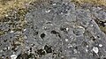
 Cup and ring marks, Blackshaw Hill, the Kings Road, West Kilbride, North Ayrshire.jpg 4,896 × 2,752; 7.45 MB
-
 Drystane dyke and Blackshaw Hill - geograph.org.uk - 1153435.jpg 640 × 428; 51 KB
-
 Hoof mark petrosomatoglyphs. Blackshaw Hill, West Kilbride, North Ayrshire.jpg 4,896 × 2,752; 5.12 MB
-
 Hopeton Farm ruins, Blackshaw Hill, the Kings Road, West Kilbride, North Ayrshire.jpg 3,730 × 2,127; 1.95 MB
-
 Western slopes of Blackshaw Hill - geograph.org.uk - 1153413.jpg 640 × 428; 57 KB


