Category:Blikkenburgerlaan 2b-2c Zeist
| Object location | | View all coordinates using: OpenStreetMap |
|---|
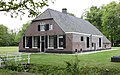
farmhouse in Zeist, Netherlands  | |||||
| Upload media | |||||
| Instance of | |||||
|---|---|---|---|---|---|
| Part of | |||||
| Location | Zeist, Utrecht, Netherlands | ||||
| Street address |
| ||||
| Located on street |
| ||||
| Heritage designation |
| ||||
 | |||||
|
This is a category about rijksmonument number 520079
|
| Address |
|
Media in category "Blikkenburgerlaan 2b-2c Zeist"
The following 5 files are in this category, out of 5 total.
-
 Linker zijgevel - Zeist - 20221584 - RCE.jpg 1,200 × 954; 290 KB
-
 Voorzijde - Zeist - 20221583 - RCE.jpg 1,200 × 959; 352 KB
-
 Zeist - Blikkenburgerlaan 2b-2c RM40343.JPG 4,539 × 2,850; 1.28 MB
-
 Zeist Blikkenburgerlaan 2b-2c Achterzijde.jpg 3,556 × 1,990; 3.75 MB
-
 Zij- en achtergevel - Zeist - 20221585 - RCE.jpg 1,200 × 955; 303 KB


