Category:Blue Mesa Dam
dam in Cimarron, Gunnison County, Colorado, USA  | |||||
| Upload media | |||||
| Instance of | |||||
|---|---|---|---|---|---|
| Located in protected area | |||||
| Location | Gunnison County, Colorado | ||||
| Located in or next to body of water | |||||
| Owned by | |||||
| Operator | |||||
| Carries | |||||
| Service entry |
| ||||
| Inception |
| ||||
| Nominal power capacity |
| ||||
| Length |
| ||||
| Height |
| ||||
| Elevation above sea level |
| ||||
| Drainage basin |
| ||||
| Reservoir created | |||||
 | |||||
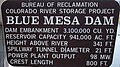
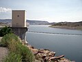
English: Blue Mesa Dam is a zoned earthfill dam on the Gunnison River in Colorado. It creates Blue Mesa Reservoir and is within Curecanti National Recreation Area just before the river enters the Black Canyon of the Gunnison. The dam is upstream of the Morrow Point Dam. Blue Mesa Dam and reservoir are part of the Bureau of Reclamation's Wayne N. Aspinall Unit of the Colorado River Storage Project, which retains the waters of the Colorado River and its tributaries for agricultural and municipal use in the American Southwest. The dam's primary purpose is hydroelectric power generation. Colorado State Highway 92 passes over the top of the dam. Blue Mesa Dam houses two turbine generators and produces an average of 264,329,000 kilowatt-hours each year.
Media in category "Blue Mesa Dam"
The following 6 files are in this category, out of 6 total.
-
 Blue Mesa Dam (1) (5932141131).jpg 4,454 × 3,977; 5.98 MB
-
 Blue Mesa Dam (2) (5932141979).jpg 6,330 × 5,223; 13.05 MB
-
 Blue Mesa Dam (2).JPG 1,666 × 930; 1.44 MB
-
 Blue Mesa Dam (3).JPG 2,048 × 1,536; 2.3 MB
-
 Blue Mesa Dam (7).JPG 2,048 × 1,536; 2.15 MB
-
 Bluemesadam.JPG 2,560 × 1,920; 1,013 KB
_(5932141131).jpg)
_(5932141979).jpg)
.JPG)
.JPG)
.JPG)