Category:Bogan Shire
Deutsch: Bogan Shire ist ein lokales Verwaltungsgebiet (LGA) im australischen Bundesstaat New South Wales. Das Gebiet ist 14.611 km² groß und hat etwa 2.900 Einwohner. (→Bogan Shire)
English: Bogan Shire is a local government area in the Orana region of New South Wales, Australia. The Shire is located adjacent to the Mitchell and Barrier highways and its only significant town is Nyngan. (→Bogan Shire)
Français : Le comté de Bogan est une zone d'administration locale dans le nord de la Nouvelle-Galles du Sud en Australie. (→Comté de Bogan)
Gaeilge: Bardas (nó ceantar rialtais áitiúil) i New South Wales, an Astráil is ea Bogan. Tá daonra timpeall 3,100 ann. (→Bogan)
Italiano: La Contea di Bogan è una Local Government Area che si trova nel Nuovo Galles del Sud. Essa si estende su di una superficie di 14.611 chilometri quadrati ed ha una popolazione di 3.003 abitanti. La sede del consiglio si trova a Nyngan. (→Contea di Bogan)
Nederlands: Bogan Shire Council is een Local Government Area (LGA) in de Australische deelstaat Nieuw-Zuid-Wales. (→Bogan Shire Council)
local government area in New South Wales, Australia   | |||||
| Upload media | |||||
| Instance of | |||||
|---|---|---|---|---|---|
| Location | New South Wales, AUS | ||||
| Capital | |||||
| Legislative body |
| ||||
| Population |
| ||||
| Area |
| ||||
| Elevation above sea level |
| ||||
| official website | |||||
 | |||||
Subcategories
This category has the following 12 subcategories, out of 12 total.
B
- Babinda, New South Wales (1 F)
- Bodabah, New South Wales (1 F)
- Bogan Shire Council offices (11 F)
C
- Coolabah, New South Wales (4 F)
G
H
M
- Miandetta, New South Wales (1 F)
N
P
Media in category "Bogan Shire"
The following 4 files are in this category, out of 4 total.
-
 Australia-Map-NSW-LGA-Bogan.png 720 × 593; 29 KB
-
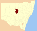 Bogan LGA NSW.png 400 × 337; 33 KB
-
 Hermidale Bogan Shire Municipal Border Sign.JPG 4,856 × 3,598; 6.54 MB
-
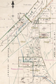 The Overflow Parish 1880.png 464 × 692; 625 KB


