Category:Bolan Pass
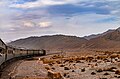
English: Bolan Pass is a historical route through the mountainous region of western Balochistan, Pakistan, located 120 km (75 mi) from the Afghanistan border. The pass is an 89 km (55 mi) stretch of the Bolan River valley from Rindli (Dhadar area) in the south to Darwāza near Kolpur in the north. It is made up of roads and railways through a number of long, narrow gorges and tunnels.
Dadur (Dhadar, Kachhi, Balochistan, Pakistan) is the entrance to the Bolan Pass in the South.
mountain pass in Pakistan  | |||||
| Upload media | |||||
| Instance of | |||||
|---|---|---|---|---|---|
| Location | Balochistan, Pakistan | ||||
| Mountain range |
| ||||
| Elevation above sea level |
| ||||
| Different from | |||||
 | |||||
Subcategories
This category has the following 4 subcategories, out of 4 total.
I
P
R
T
Media in category "Bolan Pass"
The following 33 files are in this category, out of 33 total.
-

-
 Beloochees in the Bolan Pass, 1839 (frontispiece) - NAM 1016298.jpg 638 × 960; 157 KB
-
 Bolan - panoramio (1).jpg 4,608 × 3,456; 5.87 MB
-
 Bolan Pass 1842.jpg 423 × 628; 107 KB
-
 Bolan pass after railway2.jpg 685 × 698; 347 KB
-
 Bolan Pass, rail and road, Balochistan, Pakistan.jpg 960 × 540; 67 KB
-

-
 Entrance to the Bolan Pass from Dadur LCCN2007681518.jpg 5,868 × 8,532; 8.34 MB
-
 Firstanglo-afghanwar.gif 603 × 413; 111 KB
-

-

-
 Heritage of Bolan.jpg 5,086 × 3,391; 16.25 MB
-
 Horizons Balochistan - moving train at Bolan Balochistan.jpg 5,472 × 3,648; 6.15 MB
-
 ILN 1842, p. 468.jpg 950 × 1,390; 184 KB
-
 Kolpur Balochistan - moving train at Bolan Balochistan.jpg 5,340 × 3,504; 6.48 MB
-

-
 Mountainous lizard in Bolan Pass, Balochistan.jpg 647 × 960; 164 KB
-
 Near Pinjarah Bridge, Baluchistan, Pakistan - panoramio.jpg 4,608 × 3,456; 5.79 MB
-
 Rail track of Bolan Pass, Balochistan.jpg 720 × 540; 70 KB
-
 Railway bridge BOLAN pass.jpg 720 × 540; 107 KB
-
 Sir - I -Khajur in the Bolan Pass, 1839.jpg 1,200 × 836; 169 KB
-
 Streckenprofil Bolanbahn.png 2,486 × 1,730; 164 KB
-

-

-
 The British army entering Bolan pass.jpg 1,113 × 1,710; 289 KB
-
 The encampment at Dadur with the entrance to the Bolan Pass LCCN2016647828.jpg 8,516 × 5,988; 6.78 MB
-

-
 The Opening in to the Narrow Path above the Siri Bolan.jpg 3,145 × 2,071; 2.68 MB
-
 The opening into the narrow pass above the Siri Bolan LCCN2016647830.jpg 8,472 × 5,952; 7.51 MB
-

-
 The wild pass of Siri Kajoor LCCN95509508.jpg 8,436 × 5,892; 7.79 MB
-
 The Wild Pass of Siri-Kajoor, 1840 (c) - NAM 1016304.jpg 960 × 646; 159 KB
-
 View in Bolan Pass LCCN2004707695.jpg 451 × 420; 24 KB
_-NYPL.jpg)
_-_NAM_1016298.jpg)
.jpg)


,_1839_-_NAM_1016303.jpg)


_(14758744896).jpg)


,_John_Frederick_Irwin.jpg)


_-_NAM_1016304.jpg)
