Category:Botne, Vinje
| Object location | | View all coordinates using: OpenStreetMap |
|---|
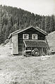
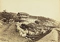
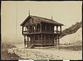
English: Botne, farm with several buildings in Nesland, Vinje municipality, Telemark, Norway. From the 18th century, protected by law in 1923 (no: "fredet").
farm in Vinje  | |||||
| Upload media | |||||
| Instance of |
| ||||
|---|---|---|---|---|---|
| Location | Vinje, Telemark, Norway | ||||
| Heritage designation |
| ||||
 | |||||
Media in category "Botne, Vinje"
The following 18 files are in this category, out of 18 total.
-
 Botne, Telemark - Riksantikvaren-T177 01 0100.jpg 3,516 × 2,320; 8.13 MB
-
 Botne, Telemark - Riksantikvaren-T177 01 0101.jpg 3,460 × 2,324; 7.61 MB
-
 Botne, Telemark - Riksantikvaren-T177 01 0102.jpg 2,354 × 3,650; 9.97 MB
-
 Botne, Telemark - Riksantikvaren-T177 01 0103.jpg 2,288 × 3,640; 9.59 MB
-
 Botne, Telemark - Riksantikvaren-T177 01 0104.jpg 3,619 × 2,298; 8.06 MB
-
 Botne, Telemark - Riksantikvaren-T177 01 0105.jpg 3,652 × 2,172; 7.87 MB
-
 Botne, Telemark - Riksantikvaren-T177 01 0106.jpg 3,616 × 2,336; 8.3 MB
-
 Botne, Telemark - Riksantikvaren-T177 01 0110.jpg 3,614 × 2,210; 6.57 MB
-
 Botne, Telemark - Riksantikvaren-T177 01 0111.jpg 2,188 × 3,564; 7.49 MB
-
 Botne, Telemark - Riksantikvaren-T177 01 0115.jpg 2,349 × 3,585; 7.4 MB
-
 Botne, Telemark - Riksantikvaren-T177 01 0116.jpg 2,360 × 3,585; 7.74 MB
-
 Botne, Telemark - Riksantikvaren-T177 01 0117.jpg 3,568 × 2,334; 6.77 MB
-
 Botne, Telemark - Riksantikvaren-T177 01 0118.jpg 3,667 × 2,334; 6.17 MB
-
 Botne, Telemark - Riksantikvaren-T177 01 0119.jpg 3,708 × 2,345; 8.14 MB
-
-
 8886 Parti af Botten, Telemarken - no-nb digifoto 20160405 00135 bldsa L KK0257.jpg 7,592 × 5,553; 4.34 MB
-

-
 8888 Stabur paa Botten, Telemarken - no-nb digifoto 20160405 00136 bldsa L KK0258.jpg 7,573 × 5,570; 3.33 MB


.jpg)

.jpg)
