Category:Boulder Mountain (Utah)
mountain in Garfield and Wayne counties in Utah, United States  | |||||
| Upload media | |||||
| Instance of | |||||
|---|---|---|---|---|---|
| Part of | |||||
| Location |
| ||||
| Topographic prominence |
| ||||
| Different from | |||||
 | |||||
English: Media related to Boulder Mountain (Utah) a mountain on the Aquarius Plateau in the Dixie National Forest in Garfield and Wayne counties in Utah, United States, that lies at the southwest perimeter of the San Rafael Desert region, in the north Canyon Lands of Utah. (The Aquarius Plateau is also on the northeast perimeter of the High Plateaus section of the Colorado Plateau.)
Media in category "Boulder Mountain (Utah)"
The following 42 files are in this category, out of 42 total.
-
 2008-0914-CapitolReef-WaterpocketFold1.jpg 3,412 × 1,976; 5.41 MB
-
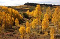
 Aspens, Boulder Mountain (3678755867).jpg 1,600 × 1,057; 593 KB
-
 Aspens, Boulder Mountain (3679558910).jpg 1,057 × 1,600; 873 KB
-
 Blind Lake, Wayne County, Utah.jpg 5,312 × 2,988; 6.45 MB
-
 Boulder mountain 2.jpg 2,048 × 1,536; 212 KB
-
 Boulder Mountain West.jpg 3,397 × 1,078; 476 KB
-
 BOULDER MT, GARFIELD COUNTY, UT - 2016-09-30 fall color (1) (30427884535).jpg 2,222 × 1,142; 2.8 MB
-
 BOULDER MT, GARFIELD COUNTY, UT - 2016-09-30 fall color (10) (30379031226).jpg 2,222 × 1,481; 3.57 MB
-
 BOULDER MT, GARFIELD COUNTY, UT - 2016-09-30 fall color (11) (29783354993).jpg 2,222 × 1,156; 3.17 MB
-
 BOULDER MT, GARFIELD COUNTY, UT - 2016-09-30 fall color (12) (30341412071).jpg 2,222 × 3,333; 8.19 MB
-
 BOULDER MT, GARFIELD COUNTY, UT - 2016-09-30 fall color (2) (30341448531).jpg 2,222 × 1,351; 4.22 MB
-
 BOULDER MT, GARFIELD COUNTY, UT - 2016-09-30 fall color (3) (30391754026).jpg 2,222 × 1,242; 3.4 MB
-
 BOULDER MT, GARFIELD COUNTY, UT - 2016-09-30 fall color (4) (30391777316).jpg 2,222 × 1,432; 4.43 MB
-
 BOULDER MT, GARFIELD COUNTY, UT - 2016-09-30 fall color (5) (30311176832).jpg 2,222 × 1,566; 4.2 MB
-
 BOULDER MT, GARFIELD COUNTY, UT - 2016-09-30 fall color (6) (30298545992).jpg 2,222 × 1,463; 4.41 MB
-
 BOULDER MT, GARFIELD COUNTY, UT - 2016-09-30 fall color (7) (30415288645).jpg 2,222 × 1,463; 4.77 MB
-
 BOULDER MT, GARFIELD COUNTY, UT - 2016-09-30 fall color (9) (30379036706).jpg 2,222 × 1,129; 4.34 MB
-
 BOULDER MT, UT - 2016-09-30 fall color -01b from circle cliffs (30404892556).jpg 5,184 × 1,870; 7.69 MB
-
 BOULDER MT, UT - 2016-09-30 fall color -01c (31659724515).jpg 4,214 × 2,969; 14.67 MB
-
 BOULDER MT, UT - 2016-09-30 fall color -01e from circle cliffs (30404864166).jpg 5,184 × 3,456; 14.26 MB
-
 BOULDER MT, UT - 2016-09-30 fall color -01g (31623077886).jpg 5,184 × 3,152; 19.53 MB
-
 BOULDER MT, UT - 2016-09-30 fall color -15a (31659754985).jpg 5,184 × 3,354; 25.17 MB
-
 BOULDER MT, UT - 2016-09-30 fall color -22b (31659772705).jpg 4,684 × 3,456; 26.3 MB
-
 BOULDER MT, UT - 2016-09-30 fall color -24b (30849744993).jpg 5,184 × 2,634; 23.21 MB
-
 Boulder Mt. Fall - panoramio.jpg 5,184 × 3,456; 8.3 MB
-
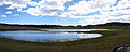 Boulder mtn lake.jpg 3,030 × 1,224; 1,010 KB
-
 Capital Reef satellite image.jpg 4,221 × 4,209; 8.29 MB
-
 Capitalreef.jpg 408 × 566; 76 KB
-
 Capitol-Reef-NP-TF.jpg 4,800 × 2,700; 3.87 MB
-
 Circle Cliffs and Henry Mtns from Boulder Mtn (3679933386).jpg 1,600 × 1,063; 403 KB
-
 Cloud over Boulder Mtn (3684617703).jpg 1,600 × 781; 372 KB
-
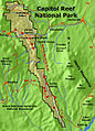
 Map of Capitol Reef National Park.png 2,458 × 4,425; 2.54 MB
-
 Scenic Byway 12 - A Sweeping View from Boulder Mountain - NARA - 7721710.jpg 3,000 × 1,986; 1.6 MB
-
 Scenic Byway 12 - Fall Colors on Quaking Aspens - NARA - 7721839.jpg 360 × 500; 173 KB
-

-

-
 Scenic Byway 12 - Overlook for the Henry Mountains - NARA - 7721909.jpg 742 × 484; 288 KB
-
 Scenic Byway 12 - Rugged Splendor in Color Country - NARA - 7721945.jpg 2,596 × 1,628; 1.22 MB
-

-
 Scenic Byway 12 - Visitors Looking Out Over Dixie National Forest - NARA - 7721879.jpg 1,796 × 1,173; 664 KB
-
 Snow on Boulder Mountain in late spring (3685113158).jpg 1,600 × 1,200; 439 KB
-
 UTMap-doton-BoulderMtn.png 153 × 200; 1 KB

.jpg)
.jpg)


_(30427884535).jpg)
_(30379031226).jpg)
_(29783354993).jpg)
_(30341412071).jpg)
_(30341448531).jpg)
_(30391754026).jpg)
_(30391777316).jpg)
_(30311176832).jpg)
_(30298545992).jpg)
_(30415288645).jpg)
_(30379036706).jpg)
.jpg)
.jpg)
.jpg)
.jpg)
.jpg)
.jpg)


.jpg)
.jpg)


.jpg)

.jpg)