Category:Braco
English: Braco is a village in Perth and Kinross, Scotland. It is located 5 miles from Dunblane towards Perth down the A9 road.
village in Perth and Kinross, Scotland, UK  | |||||
| Upload media | |||||
| Instance of | |||||
|---|---|---|---|---|---|
| Location |
| ||||
| Population |
| ||||
 | |||||
Subcategories
This category has the following 4 subcategories, out of 4 total.
A
- Ardoch Old Bridge (8 F)
- Ardoch Parish Church (2 F)
- Ardoch Roman Fort (8 F)
B
- Braco Castle (7 F)
Media in category "Braco"
The following 74 files are in this category, out of 74 total.
-
 A 822 near Garrick - geograph.org.uk - 910943.jpg 640 × 463; 89 KB
-
 Ardoch Free Church Tower, Braco (geograph 6545013).jpg 1,200 × 1,600; 584 KB
-
 Ardoch Roman Fort, Braco, Perth and Kinross.jpg 4,896 × 3,672; 3.38 MB
-
 B827 bridge over wooded glen - geograph.org.uk - 50633.jpg 640 × 480; 128 KB
-
 Blasted tree - geograph.org.uk - 348059.jpg 640 × 480; 109 KB
-
 Braco from the East - geograph.org.uk - 526710.jpg 640 × 482; 93 KB
-
 Braco from the North - geograph.org.uk - 526748.jpg 640 × 478; 69 KB
-
 Braco Hotel and Main Street - geograph.org.uk - 401020.jpg 640 × 480; 117 KB
-
 Braco main street, Perth and Kinross.jpg 4,896 × 2,828; 2.7 MB
-
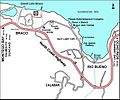 Braco map.jpg 1,436 × 1,193; 486 KB
-
 Bridge and road to Keirallan - geograph.org.uk - 50607.jpg 480 × 640; 124 KB
-
-
 Christmas tree plantation - geograph.org.uk - 625942.jpg 640 × 480; 109 KB
-
 Dereliction at Nether Braco - geograph.org.uk - 348002.jpg 640 × 480; 110 KB
-

-
 East of Clatteringford - geograph.org.uk - 489365.jpg 605 × 640; 91 KB
-
 Forest edge, Feddal Forest - geograph.org.uk - 625926.jpg 640 × 480; 100 KB
-
 Forest Track, Feddal Forest - geograph.org.uk - 625871.jpg 640 × 480; 73 KB
-
 Forestry, near Crofthead - geograph.org.uk - 625939.jpg 640 × 480; 91 KB
-
 Gannochan Farm entrance. - geograph.org.uk - 489543.jpg 640 × 467; 114 KB
-
 Looking South along Main Street, Braco.jpg 480 × 640; 92 KB
-

-
 Scots pines on the Cromlet track - geograph.org.uk - 348063.jpg 640 × 480; 94 KB
-
 Straight on for Dunduff - geograph.org.uk - 349805.jpg 480 × 640; 111 KB
-
 Tamano, Kinbuck, Perthshire - geograph.org.uk - 146979.jpg 270 × 360; 86 KB
-
 The Ardoch Roman Fort, Braco, Perth and Kinross.jpg 4,896 × 3,672; 3.21 MB
-
 The River Knaik - geograph.org.uk - 349795.jpg 640 × 480; 122 KB
-
 Track beside the Corriebeagh Burn - geograph.org.uk - 1392397.jpg 640 × 480; 197 KB
-
 Allanbank Inn, Greenloaning - geograph.org.uk - 50602.jpg 640 × 480; 102 KB
-
 Approaching the end - geograph.org.uk - 349873.jpg 480 × 640; 83 KB
-
 Baby Trees and Fields - geograph.org.uk - 179887.jpg 640 × 481; 150 KB
-
 Ben Clach from the B827 - geograph.org.uk - 50635.jpg 640 × 480; 70 KB
-
 Bullie Burn - geograph.org.uk - 625931.jpg 640 × 480; 90 KB
-
 Carsebreck Loch - geograph.org.uk - 493245.jpg 640 × 463; 57 KB
-
 Clattering Ford - geograph.org.uk - 488878.jpg 640 × 467; 84 KB
-
 Dried up stream - geograph.org.uk - 489077.jpg 640 × 470; 68 KB
-

-
 Glenuchorn Farm - geograph.org.uk - 50638.jpg 640 × 480; 88 KB
-
 Greenscares - geograph.org.uk - 256029.jpg 640 × 480; 90 KB
-

-
 Heading up to Cromlet - geograph.org.uk - 348067.jpg 640 × 480; 108 KB
-
 JCB, Feddal Forest - geograph.org.uk - 625927.jpg 640 × 480; 90 KB
-
 Looking east from the Cromlet track - geograph.org.uk - 349887.jpg 640 × 480; 76 KB
-
 Looking East towards Netherton farm - geograph.org.uk - 493379.jpg 640 × 472; 65 KB
-
 Millhills Cottage - geograph.org.uk - 489356.jpg 640 × 473; 95 KB
-
 Muckle Burn running under the B8033 - geograph.org.uk - 179836.jpg 481 × 640; 144 KB
-

-
 New gravel pit - geograph.org.uk - 349792.jpg 640 × 480; 107 KB
-
 New road above Nether Braco - geograph.org.uk - 348007.jpg 480 × 640; 110 KB
-
 New shed near Braco Castle - geograph.org.uk - 348014.jpg 640 × 480; 89 KB
-
 North East towards Carsebreck - geograph.org.uk - 496978.jpg 640 × 481; 49 KB
-
 North East towards Clatteringford - geograph.org.uk - 488884.jpg 640 × 459; 56 KB
-
 North from Netherton - geograph.org.uk - 493374.jpg 640 × 473; 60 KB
-
 North West to Clatteringford. - geograph.org.uk - 493891.jpg 640 × 480; 66 KB
-
 Old House of Orchil Gardens - geograph.org.uk - 493944.jpg 640 × 479; 119 KB
-
 Old Well^ - geograph.org.uk - 489633.jpg 640 × 487; 139 KB
-
 Orchill Farm - geograph.org.uk - 489168.jpg 640 × 464; 81 KB
-
 Orchill Loch - geograph.org.uk - 489090.jpg 640 × 456; 65 KB
-
 Pond, Easter Feddal - geograph.org.uk - 625944.jpg 640 × 480; 88 KB
-
 Ratha Centre at Upper Ardoch - geograph.org.uk - 50625.jpg 640 × 480; 99 KB
-
 Small burn, Feddal Forest - geograph.org.uk - 625914.jpg 480 × 640; 101 KB
-
 Some say Orchil, some say Orchill. - geograph.org.uk - 493912.jpg 640 × 457; 102 KB
-
 South of Millhills - geograph.org.uk - 491467.jpg 640 × 469; 91 KB
-

-
 The NE slope of Cromlet - geograph.org.uk - 349878.jpg 640 × 480; 71 KB
-
 The track to Braco Castle Farm - geograph.org.uk - 349798.jpg 640 × 480; 96 KB
-
 The track to Cromlet - geograph.org.uk - 349845.jpg 640 × 480; 94 KB
-
 The trig on Cromlet - geograph.org.uk - 349853.jpg 640 × 480; 76 KB
-
 The trig on Cromlet - geograph.org.uk - 349882.jpg 640 × 480; 78 KB
-
 Track junction, Feddal Forest - geograph.org.uk - 625907.jpg 640 × 480; 87 KB
-
 Track to Cromlet - geograph.org.uk - 349838.jpg 640 × 480; 110 KB
-
 Track to Faulds Farm - geograph.org.uk - 179870.jpg 640 × 481; 114 KB
-

-
 Woodland Sign at Upper Ardoch - geograph.org.uk - 50626.jpg 640 × 480; 101 KB

.jpg)


