Category:Bradworthy
village in Devon, England, UK  | |||||
| Upload media | |||||
| Instance of | |||||
|---|---|---|---|---|---|
| Location | Torridge, Devon, South West England, England | ||||
 | |||||
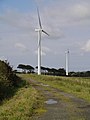
English: Bradworthy is a village in Devon, England. The village is close to the site of the first Wind turbines in Devon, put up in 2005.
Subcategories
This category has the following 6 subcategories, out of 6 total.
A
- Alfardisworthy (4 F)
B
- Bradworthy War Memorial (4 F)
E
- East Youlstone (1 F)
S
- Stowford, Bradworthy (1 F)
Media in category "Bradworthy"
The following 158 files are in this category, out of 158 total.
-

-
 A roadside hedge topping pillar near Whitely Cross - geograph.org.uk - 4740969.jpg 4,000 × 3,000; 2.83 MB
-
 Access track to East Ash - geograph.org.uk - 4114428.jpg 1,024 × 698; 162 KB
-
 Agricultural Machine by Lower Tamar Lake.jpg 2,984 × 2,352; 3.14 MB
-
 Alfardisworthy Holy Well (geograph 7104215).jpg 1,600 × 1,200; 869 KB
-
 Approaching Bradworthy - geograph.org.uk - 1576896.jpg 640 × 480; 69 KB
-
 Approaching East Ash Cross - geograph.org.uk - 4114425.jpg 1,024 × 673; 104 KB
-
 At Great Dinworthy - geograph.org.uk - 741110.jpg 640 × 480; 148 KB
-
 Atworthy Cross - geograph.org.uk - 3624844.jpg 1,024 × 768; 109 KB
-
 Barns at Loatmead Farm - geograph.org.uk - 698132.jpg 640 × 362; 57 KB
-
 Beech avenue near Berridon - geograph.org.uk - 743724.jpg 480 × 640; 131 KB
-

-
 Bend in the road south of Jenns Cross - geograph.org.uk - 2982650.jpg 800 × 600; 299 KB
-
 Bending with the wind - geograph.org.uk - 4114420.jpg 1,024 × 664; 177 KB
-
 Berridon Woods - geograph.org.uk - 741081.jpg 640 × 480; 134 KB
-
 Berridon Woods - geograph.org.uk - 743732.jpg 640 × 428; 80 KB
-
 Blatchborough Cross - geograph.org.uk - 4105976.jpg 1,600 × 1,060; 469 KB
-
 Boundary Stone on Woolley Moor.jpg 2,848 × 3,408; 4.51 MB
-
 Bradworthy - geograph.org.uk - 411203.jpg 640 × 426; 106 KB
-
 Bradworthy Square - geograph.org.uk - 421528.jpg 640 × 426; 91 KB
-

-
 Bridge near Brimford Bridge - geograph.org.uk - 3624880.jpg 1,024 × 768; 223 KB
-
 Bridge over stream near Pennybrook Farm - geograph.org.uk - 2982629.jpg 800 × 600; 518 KB
-
 Brimford Bridge and signpost at Brimford Cross - geograph.org.uk - 3624876.jpg 1,024 × 768; 145 KB
-

-

-

-

-
 Brimford Cross - geograph.org.uk - 4107128.jpg 1,600 × 1,060; 645 KB
-
 Brimford Cross, near Meddon - geograph.org.uk - 1576888.jpg 640 × 480; 89 KB
-
 Carpet of celandines - geograph.org.uk - 743782.jpg 480 × 640; 163 KB
-
 Cleverdon Cross and Cleverdon Cottage - geograph.org.uk - 3624781.jpg 1,024 × 768; 135 KB
-

-
 Cottage at East Ash - geograph.org.uk - 689525.jpg 640 × 480; 67 KB
-

-

-

-
-

-
 Down to the Torridge river valley - geograph.org.uk - 4114431.jpg 800 × 573; 103 KB
-
 Dripping with moss - geograph.org.uk - 681602.jpg 480 × 640; 177 KB
-
 Dural Cross - geograph.org.uk - 3624861.jpg 1,024 × 683; 73 KB
-
 East Ash Cross - geograph.org.uk - 689532.jpg 640 × 480; 50 KB
-

-
 Edge of a plantation - geograph.org.uk - 698145.jpg 640 × 480; 128 KB
-
 Edge of woodland near Hardisworthy - geograph.org.uk - 511254.jpg 640 × 480; 128 KB
-
 Entrance to Newlands Farm - geograph.org.uk - 4107155.jpg 1,600 × 1,060; 355 KB
-
 Farm buildings at Newlands - geograph.org.uk - 2982636.jpg 800 × 600; 443 KB
-
 Farmhouse at Cleverdon - geograph.org.uk - 414692.jpg 640 × 426; 118 KB
-
 Field above Newlands Moor - geograph.org.uk - 504385.jpg 640 × 480; 128 KB
-
 Field near Atworthy - geograph.org.uk - 741178.jpg 640 × 461; 82 KB
-
 Field near Bradworthy - geograph.org.uk - 741009.jpg 640 × 480; 111 KB
-
 Field near Bradworthy - geograph.org.uk - 743182.jpg 640 × 480; 99 KB
-
 Field near Horton Farm - geograph.org.uk - 259561.jpg 632 × 408; 50 KB
-
 Field near Newlands - geograph.org.uk - 509240.jpg 640 × 392; 95 KB
-

-
 Footbridge between Tamar Lakes.jpg 3,692 × 2,704; 4.88 MB
-
 Footpath near Whiteley - geograph.org.uk - 741149.jpg 480 × 640; 146 KB
-
 Ford at Instaple Farm - geograph.org.uk - 5924825.jpg 4,032 × 3,024; 7.01 MB
-
 Ford Mill Bridge - geograph.org.uk - 1820098.jpg 1,024 × 768; 334 KB
-
 Ford Mill Bridge - geograph.org.uk - 1820103.jpg 1,024 × 768; 253 KB
-
 Ford Mill Bridge as seen from downstream - geograph.org.uk - 1820108.jpg 1,024 × 768; 324 KB
-
 Ford near Instaple - geograph.org.uk - 743038.jpg 480 × 640; 120 KB
-
 Gate and footpath - geograph.org.uk - 698120.jpg 640 × 480; 139 KB
-
 Gateway at Jenns Cross - geograph.org.uk - 505777.jpg 480 × 640; 130 KB
-
 Gorse and blackthorn - geograph.org.uk - 410128.jpg 480 × 640; 272 KB
-
 Greadon Farm - geograph.org.uk - 698111.jpg 640 × 480; 89 KB
-
 Green Lane near Dinworthy - geograph.org.uk - 743777.jpg 640 × 480; 77 KB
-
 Head water of the Tamar - geograph.org.uk - 698156.jpg 480 × 640; 122 KB
-
 Horton Bridge - geograph.org.uk - 1819909.jpg 1,024 × 768; 335 KB
-
 Horton Bridge - geograph.org.uk - 1819918.jpg 1,024 × 768; 316 KB
-
 Horton Bridge as seen from Upstream - geograph.org.uk - 1819936.jpg 1,024 × 768; 401 KB
-
 Horton Cross, Northmoor - geograph.org.uk - 3624853.jpg 1,024 × 768; 99 KB
-
 House at Cleverdon Cross - geograph.org.uk - 411219.jpg 640 × 426; 146 KB
-
 House at Silworthy Cross - geograph.org.uk - 414701.jpg 640 × 426; 97 KB
-
 Infant river Tamar - geograph.org.uk - 698185.jpg 640 × 480; 154 KB
-

-
 Instaple - geograph.org.uk - 740976.jpg 640 × 480; 136 KB
-
 Instaple Cross - geograph.org.uk - 2982657.jpg 800 × 600; 317 KB
-
 Instaple Cross - geograph.org.uk - 504148.jpg 640 × 480; 103 KB
-
 Instaple Cross - geograph.org.uk - 507520.jpg 640 × 455; 101 KB
-
 Jenns Cross - geograph.org.uk - 505771.jpg 640 × 450; 102 KB
-
 Junction, Great Dinworthy - geograph.org.uk - 743780.jpg 640 × 480; 139 KB
-
 Converted chapel near Kimworthy - geograph.org.uk - 411210.jpg 640 × 426; 130 KB
-
 Kimworthy Cottage - geograph.org.uk - 411214.jpg 640 × 426; 88 KB
-
 Lane near Little Dinworthy Farm - geograph.org.uk - 4106538.jpg 1,600 × 1,087; 631 KB
-
 Lane near Trentworthy Cross - geograph.org.uk - 4106503.jpg 1,600 × 1,060; 583 KB
-
 Lane through Blatchborough Plantation - geograph.org.uk - 4105954.jpg 1,600 × 1,060; 676 KB
-
 Lane to Alfardisworthy - geograph.org.uk - 509155.jpg 640 × 480; 128 KB
-
 Lane to Ashdown Cross - geograph.org.uk - 4114422.jpg 1,600 × 1,080; 380 KB
-
 Lane to Instaple - geograph.org.uk - 509142.jpg 640 × 480; 152 KB
-
 Lane to Kimworthy - geograph.org.uk - 509369.jpg 640 × 470; 110 KB
-
 Leaning with the wind - geograph.org.uk - 4107845.jpg 1,600 × 936; 465 KB
-
 Leyland Cross, Bradworthy - geograph.org.uk - 3624799.jpg 1,024 × 768; 245 KB
-
 Little used lane near Redmonsford - geograph.org.uk - 4106522.jpg 1,600 × 1,060; 553 KB
-
 Lower Tamar Lake near Bude - geograph.org.uk - 3760704.jpg 1,024 × 768; 171 KB
-
 Manure near Worden - geograph.org.uk - 509354.jpg 640 × 480; 126 KB
-
 New Bridge over River Tamar - geograph.org.uk - 2982623.jpg 800 × 600; 528 KB
-
 North Moor Cross - geograph.org.uk - 3624848.jpg 1,024 × 585; 73 KB
-
 North Newlands - geograph.org.uk - 509200.jpg 640 × 467; 94 KB
-
 North Road, Bradworthy - geograph.org.uk - 3431928.jpg 816 × 612; 121 KB
-
 Old corrugated iron farm building - geograph.org.uk - 1165249.jpg 640 × 480; 84 KB
-
 Ordnance Survey Cut Mark - geograph.org.uk - 3720006.jpg 4,000 × 3,000; 3.9 MB
-

-
 Ploughed field at Cleverdon - geograph.org.uk - 414695.jpg 640 × 426; 109 KB
-
 Ploughed field to the east of Bradworthy - geograph.org.uk - 411885.jpg 640 × 426; 112 KB
-
 Prickly stuff near Blatchborough Cross - geograph.org.uk - 743210.jpg 480 × 640; 131 KB
-
 Primrose and ivy on tree bole - geograph.org.uk - 410158.jpg 640 × 480; 371 KB
-
 Quoit Gate Cross - geograph.org.uk - 689561.jpg 640 × 480; 84 KB
-
 Quoitgate Cross - geograph.org.uk - 3624836.jpg 1,024 × 768; 105 KB
-
 Rainy day at South Youlstone - geograph.org.uk - 4107302.jpg 1,600 × 1,096; 453 KB
-
 Reeds and marsh willow herb - geograph.org.uk - 410154.jpg 640 × 480; 155 KB
-
 River Tamar above the lakes - geograph.org.uk - 404749.jpg 480 × 640; 334 KB
-
 River Tamar below Upper Tamar Lake.jpg 3,664 × 2,848; 4.65 MB
-
 River Tamar between West and East Youlstone.jpg 3,992 × 2,848; 6.16 MB
-
 Road between West and East Youlstone.jpg 4,136 × 2,848; 5.23 MB
-

-
 Road to Bradworthy - geograph.org.uk - 743188.jpg 640 × 480; 92 KB
-
 Rural cottages at Silworthy Cross - geograph.org.uk - 4103049.jpg 1,600 × 948; 259 KB
-
 Signpost at Bradworthy Mill - geograph.org.uk - 414698.jpg 640 × 426; 161 KB
-
 Signpost at Jenn Cross - geograph.org.uk - 509327.jpg 640 × 480; 140 KB
-
 Signpost at Jenns Cross - geograph.org.uk - 2982640.jpg 600 × 800; 473 KB
-
 Spittle Ford - geograph.org.uk - 5924838.jpg 4,032 × 3,024; 5.61 MB
-
 Stream under a tree - geograph.org.uk - 698162.jpg 640 × 480; 125 KB
-

-
 The church of St John the Baptist at Bradworthy - geograph.org.uk - 3702327.jpg 4,000 × 3,000; 3.23 MB
-
 The eastern end of forestry plantations - geograph.org.uk - 3624871.jpg 1,024 × 768; 158 KB
-

-
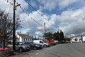 The large central square of Bradworthy - geograph.org.uk - 3624814.jpg 1,024 × 691; 140 KB
-
 The Lower Tamar Lake - geograph.org.uk - 2981445.jpg 800 × 600; 410 KB
-

-
 The river Waldon - geograph.org.uk - 411205.jpg 426 × 640; 164 KB
-
 The road to Bradworthy at Jenns Cross - geograph.org.uk - 2982646.jpg 800 × 600; 368 KB
-
 The Square at Bradworthy - geograph.org.uk - 3431952.jpg 979 × 734; 117 KB
-

-
 The view downstream from Ford Mill Bridge - geograph.org.uk - 1820127.jpg 1,024 × 768; 361 KB
-
 The view downstream from Horton Bridge - geograph.org.uk - 1819949.jpg 1,024 × 768; 385 KB
-
-
 The view upstream from Ford Mill Bridge - geograph.org.uk - 1820124.jpg 1,024 × 768; 385 KB
-
 The view upstream from Horton Bridge - geograph.org.uk - 1819940.jpg 1,024 × 768; 410 KB
-
 Towards the Waldon valley - geograph.org.uk - 743063.jpg 640 × 469; 117 KB
-
 Tree near Worden - geograph.org.uk - 509405.jpg 640 × 480; 109 KB
-
 Trees near Silworthy Cross - geograph.org.uk - 411224.jpg 426 × 640; 132 KB
-
 Unnamed lane near West Down Farm - geograph.org.uk - 4106014.jpg 1,600 × 1,021; 476 KB
-
 Unnamed lane towards Hardsworthy - geograph.org.uk - 4106561.jpg 1,600 × 1,060; 572 KB
-
 Unnamed lane towards Meddon - geograph.org.uk - 4106570.jpg 1,600 × 1,060; 546 KB
-
 Upper Tamar Lake - geograph.org.uk - 914790.jpg 640 × 591; 92 KB
-
 Upper Tamar Lake dam.jpg 4,176 × 2,848; 3.14 MB
-

-
 View east of Blatchborough Plantation - geograph.org.uk - 681598.jpg 640 × 480; 116 KB
-
 Waldon valley - geograph.org.uk - 740963.jpg 640 × 480; 105 KB
-
 Waldon valley near Dinworthy - geograph.org.uk - 741105.jpg 640 × 316; 38 KB
-
 Whitely Cross - geograph.org.uk - 689588.jpg 640 × 480; 62 KB
-
 Wind turbines - geograph.org.uk - 509386.jpg 480 × 640; 64 KB
-

-
 Wood near Stowford - geograph.org.uk - 741040.jpg 640 × 480; 97 KB
-
 Woodland near Hardisworthy - geograph.org.uk - 504151.jpg 640 × 480; 116 KB
-
 Woolley Wood - geograph.org.uk - 698204.jpg 640 × 480; 96 KB


.jpg)


