Category:Braudenstraße 9

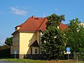
Deutsch: Wohnhaus in offener Bebauung, nach 1910 (Wohnhaus); baugeschichtlich und ortsgeschichtlich von Bedeutung
| Object location | | View all coordinates using: OpenStreetMap |
|---|
Media in category "Braudenstraße 9"
The following 5 files are in this category, out of 5 total.
-
 Braudenstraße 9 Pirna.JPG 4,320 × 2,432; 4.79 MB
-
 Elbe in Pirna 121603441.jpg 5,184 × 3,888; 11.2 MB
-
 Elbe in Pirna 121603457.jpg 5,184 × 3,888; 11.46 MB
-
 Elbe in Pirna 121603458.jpg 5,184 × 3,888; 11.87 MB
-
 Elbe in Pirna 121603464.jpg 5,184 × 3,888; 11.77 MB


