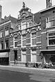
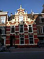
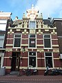
Category:Breestraat 56, Leiden
| Object location | | View all coordinates using: OpenStreetMap |
|---|
building in Leiden, Netherlands  | |||||
| Upload media | |||||
| Instance of | |||||
|---|---|---|---|---|---|
| Location | Leiden, South Holland, Netherlands | ||||
| Heritage designation |
| ||||
 | |||||
|
This is a category about rijksmonument number 24640
|
| Address |
|
Media in category "Breestraat 56, Leiden"
The following 5 files are in this category, out of 5 total.
-
 Gevel - Leiden - 20135714 - RCE.jpg 804 × 1,200; 198 KB
-
 Leiden - Breestraat 56 v2.jpg 3,024 × 4,032; 1.84 MB
-
 Leiden - Breestraat 56.JPG 2,736 × 3,648; 4.14 MB
-
 Voorgevel - Leiden - 20135712 - RCE.jpg 896 × 1,200; 244 KB
-
 Voorgevel Breestraat 56 - Leiden - 20373327 - RCE.jpg 892 × 1,200; 239 KB


