Category:Breestraat 76, Amersfoort
| Object location | | View all coordinates using: OpenStreetMap |
|---|
 | |||||
| Upload media | |||||
| Instance of | |||||
|---|---|---|---|---|---|
| Location | Amersfoort, Utrecht, Netherlands | ||||
| Street address |
| ||||
| Heritage designation |
| ||||
 | |||||
|
This is a category about rijksmonument number 7827
|
| Address |
|
Media in category "Breestraat 76, Amersfoort"
The following 56 files are in this category, out of 56 total.
-
 Achtergevel interieur - Amersfoort - 20009732 - RCE.jpg 898 × 1,200; 208 KB
-
 Achtergevel interieur bel-etage - Amersfoort - 20009726 - RCE.jpg 1,200 × 787; 228 KB
-
 Achtergevel interieur bel-etage - Amersfoort - 20009727 - RCE.jpg 1,200 × 829; 155 KB
-
 Achtergevel interieur beletage - Amersfoort - 20009721 - RCE.jpg 1,200 × 806; 243 KB
-
 Achtergevel interieur verdieping - Amersfoort - 20009736 - RCE.jpg 1,200 × 797; 204 KB
-
 Achtergevel inwendig verdieping - Amersfoort - 20009720 - RCE.jpg 1,200 × 796; 260 KB
-

-
 Achtergevel verdieping - Amersfoort - 20009735 - RCE.jpg 1,200 × 802; 279 KB
-
 Amersfoort Breestraat 76.JPG 1,944 × 2,592; 1.57 MB
-
 Detail achtergevel interieur beletage. - Amersfoort - 20009730 - RCE.jpg 800 × 1,200; 240 KB
-
 Deurkozijntje op de beletage - Amersfoort - 20009719 - RCE.jpg 805 × 1,200; 242 KB
-
 Gevel Westsingel - Amersfoort - 20009751 - RCE.jpg 1,200 × 948; 260 KB
-
 Gevel Westsingel - Amersfoort - 20009752 - RCE.jpg 1,200 × 950; 310 KB
-
 Hoofdtoegang voorgevel - Amersfoort - 20009733 - RCE.jpg 866 × 1,200; 230 KB
-
 Hoofdtoegang voorgevel details - Amersfoort - 20009734 - RCE.jpg 814 × 1,200; 256 KB
-
 Interieur - Amersfoort - 20009738 - RCE.jpg 1,200 × 788; 189 KB
-
 Interieur - Amersfoort - 20009739 - RCE.jpg 1,200 × 788; 207 KB
-
 Interieur begane grond - Amersfoort - 20009753 - RCE.jpg 1,200 × 950; 190 KB
-

-
 Nisje in buitenmuur - Amersfoort - 20009704 - RCE.jpg 1,195 × 1,200; 420 KB
-
 Nisje in buitenmuur - Amersfoort - 20009705 - RCE.jpg 1,195 × 1,200; 421 KB
-
 Onderdeel Museum Flehite - Amersfoort - 20009749 - RCE.jpg 953 × 1,200; 248 KB
-
 Onderdeel Museum Flehite - Amersfoort - 20009750 - RCE.jpg 956 × 1,200; 303 KB
-
 Periode trappenhuis zwarte decoratie schildering - Amersfoort - 20009740 - RCE.jpg 1,195 × 1,200; 300 KB
-
 Restant balkconsole - Amersfoort - 20009723 - RCE.jpg 1,200 × 804; 184 KB
-
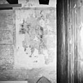
 Resten schildering - Amersfoort - 20009706 - RCE.jpg 1,186 × 1,200; 394 KB
-
 Resten van schildering - Amersfoort - 20009707 - RCE.jpg 1,195 × 1,200; 423 KB
-
 Resten van schilderingen - Amersfoort - 20009708 - RCE.jpg 1,195 × 1,200; 458 KB
-
 Resten van schilderingen - Amersfoort - 20009709 - RCE.jpg 1,192 × 1,200; 341 KB
-
 Resten van schilderingen - Amersfoort - 20009710 - RCE.jpg 1,195 × 1,200; 347 KB
-
 Resten van schilderingen - Amersfoort - 20009711 - RCE.jpg 1,200 × 1,200; 338 KB
-
 Resten van schilderingen - Amersfoort - 20009712 - RCE.jpg 1,200 × 1,200; 497 KB
-
 Resten van schilderingen - Amersfoort - 20009713 - RCE.jpg 1,189 × 1,200; 312 KB
-
 Resten van schilderingen - Amersfoort - 20009714 - RCE.jpg 1,192 × 1,200; 381 KB
-
 Resten van schilderingen - Amersfoort - 20009715 - RCE.jpg 1,195 × 1,200; 305 KB
-
 Resten van schilderingen - Amersfoort - 20009716 - RCE.jpg 1,192 × 1,200; 225 KB
-
 Schilderingen - Amersfoort - 20009756 - RCE.jpg 1,197 × 1,200; 238 KB
-
 Schilderingen - Amersfoort - 20009757 - RCE.jpg 1,200 × 1,200; 322 KB
-

-
 Venster 2e verdieping achtergevel - Amersfoort - 20009725 - RCE.jpg 897 × 1,200; 300 KB
-
 Venster achtergevel beletage - Amersfoort - 20009718 - RCE.jpg 791 × 1,200; 222 KB
-
 Venster en nis 2e verdieping achtergevel. - Amersfoort - 20009722 - RCE.jpg 817 × 1,200; 222 KB
-

-
 Verdieping - Amersfoort - 20009754 - RCE.jpg 1,200 × 944; 191 KB
-
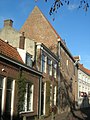
 Voorgevel - Amersfoort - 20009717 - RCE.jpg 963 × 1,200; 259 KB
-
 Voorgevel - Amersfoort - 20009744 - RCE.jpg 808 × 1,200; 258 KB
-
 Voorgevel - Amersfoort - 20009745 - RCE.jpg 804 × 1,200; 313 KB
-
 Voorgevel - Amersfoort - 20009746 - RCE.jpg 807 × 1,200; 331 KB
-
 Voorgevel - Amersfoort - 20009747 - RCE.jpg 788 × 1,200; 334 KB
-
 Voorgevel - Amersfoort - 20009748 - RCE.jpg 782 × 1,200; 306 KB
-
 Voorgevel interieur 2e verdieping - Amersfoort - 20009724 - RCE.jpg 1,200 × 807; 279 KB
-
 Voorgevel interieur bel-etage gedeelte schouw - Amersfoort - 20009728 - RCE.jpg 1,200 × 807; 241 KB
-
 Voorgevel interieur beletage schouw - Amersfoort - 20009729 - RCE.jpg 1,200 × 802; 272 KB
-
 Zolder - Amersfoort - 20009755 - RCE.jpg 1,200 × 948; 216 KB
-
 Zwarte decoratie schildering na restauratie - Amersfoort - 20009741 - RCE.jpg 1,188 × 1,200; 351 KB
-
 Zwarte decoratie schildering na restauratie - Amersfoort - 20009742 - RCE.jpg 1,197 × 1,200; 305 KB


