Category:Bridgeport Covered Bridge
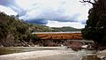
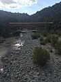
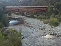
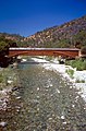
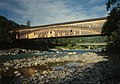
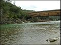
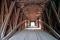
English: The Bridgeport Covered Bridge crosses the South Fork of the Yuba River in the Sierra Nevada, Northern California. The wooden covered bridge is located in South Yuba River State Park, in Bridgeport, Nevada County. The park's visitor center is adjacent to the bridge.
The bridge was originally constructed in 1862, and was part of the Virginia Turnpike Company Toll Road that served the northern gold mines, and traffic to and from Virginia City and the Comstock Lode silver mines in Nevada. The bridge is a California Historical Landmark, a National Historic Civil Engineering Landmark, and on the National Register of Historic Places in Nevada County.
|
This is a category about a place or building that is listed on the California Historical Landmark listing in the United States. Its reference number is 390.
|
bridge in Bridgeport, Nevada County, California, southwest of French Corral and north of Lake Wildwood  | |||||
| Upload media | |||||
| Instance of | |||||
|---|---|---|---|---|---|
| Location | Nevada County, California, Pacific States Region | ||||
| Crosses | |||||
| Heritage designation |
| ||||
| Date of official opening |
| ||||
| Length |
| ||||
 | |||||
Media in category "Bridgeport Covered Bridge"
The following 22 files are in this category, out of 22 total.
-
 Bridgeport Covered Bridge2.jpg 1,500 × 844; 1.35 MB
-
 Bridgeport Bride Rework.jpg 2,448 × 1,951; 1.05 MB
-
 Bridgeport Bridge at sunset.jpg 2,448 × 3,264; 2.48 MB
-
 Bridgeport Bridge Looking East.jpg 2,448 × 3,264; 2.5 MB
-
 Bridgeport Bridge Low River.jpg 2,448 × 1,604; 1.59 MB
-
 Bridgeport Bridge Right Side Damage.jpg 2,122 × 1,951; 1.06 MB
-
 Bridgeport Bridge River Crossing.jpg 3,264 × 2,448; 2.33 MB
-
 Bridgeport CA - Bridgeport Covered Bridge.jpg 799 × 531; 587 KB
-
 Bridgeport Covered Bridge - Bridgeport CA.jpg 799 × 531; 582 KB
-
 Bridgeport Covered Bridge and Barn.jpg 912 × 684; 442 KB
-
 Bridgeport covered bridge Nevada County CA.jpg 987 × 1,500; 626 KB
-
 Bridgeport Covered Bridge over the Yuba River, Nevada County, California LCCN2013633973.tif 6,144 × 4,096; 144.03 MB
-
 Bridgeport Covered Bridge over the Yuba River, Nevada County, California LCCN2013633975.tif 6,144 × 4,096; 144.04 MB
-
 Bridgeport Covered Bridge over Yuba River.jpg 912 × 684; 297 KB
-
 Bridgeport covered bridge, longest in USA.jpg 4,000 × 3,000; 2.67 MB
-
 Bridgeport Covered Bridge.jpg 964 × 676; 194 KB
-
 Covered Bridge Tilt-Shift 1.jpg 4,074 × 3,264; 4.81 MB
-
 Historic Covered Bridge in Bridgeport, CA at South Yuba River State Park 2.JPG 4,752 × 3,168; 7.64 MB
-
 Historic Covered Bridge in Bridgeport, CA at South Yuba River State Park.JPG 3,168 × 4,752; 6.54 MB
-
 Yuba River, Bridgeport, California - panoramio - UncleVinny (4).jpg 1,362 × 1,024; 411 KB
-
 Yuba River, Bridgeport, California - panoramio.jpg 1,024 × 1,362; 433 KB
-
 Yubabridge1.jpg 475 × 315; 39 KB


.jpg)

