Category:Bridleways in Northamptonshire
Ceremonial counties of England: Bedfordshire · Berkshire · Buckinghamshire · Cambridgeshire · Cheshire · Cornwall · Cumbria · Derbyshire · Devon · Dorset · Durham · East Riding of Yorkshire · East Sussex · Essex · Gloucestershire · Greater London · Greater Manchester · Hampshire · Herefordshire · Hertfordshire · Kent · Lancashire · Leicestershire · Lincolnshire · Merseyside · Norfolk · North Yorkshire · Northamptonshire · Northumberland · Nottinghamshire · Oxfordshire · Rutland · Shropshire · Somerset · South Yorkshire · Staffordshire · Suffolk · Surrey · Tyne and Wear · Warwickshire · West Midlands · West Sussex · West Yorkshire · Wiltshire · Worcestershire
City-counties:
Former historic counties:
Other former counties:
City-counties:
Former historic counties:
Other former counties:
Media in category "Bridleways in Northamptonshire"
The following 82 files are in this category, out of 82 total.
-
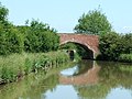
 Riders cross the River Til on a bridleway - geograph.org.uk - 527285.jpg 640 × 479; 239 KB
-

-
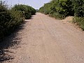
 Bridleway at Ryehill Lodge - geograph.org.uk - 223987.jpg 640 × 480; 119 KB
-
 Bridleway to Faxton. - geograph.org.uk - 456929.jpg 640 × 480; 134 KB
-

-
 Bridleway - geograph.org.uk - 422784.jpg 640 × 427; 163 KB
-
 Hall Lane, Welford - geograph.org.uk - 17206.jpg 640 × 480; 127 KB
-
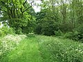
 Track through Great Wood - geograph.org.uk - 204211.jpg 640 × 541; 140 KB
-
-
 Bridle way along Withmale wood - geograph.org.uk - 390919.jpg 640 × 427; 130 KB
-
 Bridleway - geograph.org.uk - 207269.jpg 640 × 480; 95 KB
-
 Bridleway - geograph.org.uk - 427895.jpg 640 × 427; 109 KB
-
 Bridleway - geograph.org.uk - 838327.jpg 480 × 640; 102 KB
-

-
 Bridleway alongside Hostage Wood - geograph.org.uk - 269116.jpg 640 × 480; 78 KB
-
 Bridleway below Woodford Shrubbery - geograph.org.uk - 130451.jpg 640 × 480; 84 KB
-
 Bridleway beside Badsaddle Wood. - geograph.org.uk - 450714.jpg 640 × 480; 165 KB
-

-
 Bridleway heading towards Keyson - geograph.org.uk - 719962.jpg 640 × 425; 80 KB
-

-

-

-
 Bridleway north of the A14 - geograph.org.uk - 1516441.jpg 640 × 537; 65 KB
-
 Bridleway north to Fermyn Woods - geograph.org.uk - 378595.jpg 640 × 480; 111 KB
-

-
 Bridleway past small copse - geograph.org.uk - 453171.jpg 640 × 640; 196 KB
-
-

-
 Bridleway to Crossway Hand Cottages - geograph.org.uk - 269345.jpg 640 × 480; 81 KB
-
 Bridleway to Elton - geograph.org.uk - 718636.jpg 640 × 425; 115 KB
-
 Bridleway to Fritwell - geograph.org.uk - 453211.jpg 640 × 480; 182 KB
-
 Bridleway to Great Gidding - geograph.org.uk - 230131.jpg 640 × 480; 69 KB
-
 Bridleway to Papley - geograph.org.uk - 622744.jpg 640 × 480; 84 KB
-
 Bridleway to Purston - geograph.org.uk - 437123.jpg 640 × 480; 117 KB
-
 Bridleway to Short Wood - geograph.org.uk - 187420.jpg 640 × 480; 110 KB
-
 Bridleway to Upper Astrop - geograph.org.uk - 453147.jpg 640 × 640; 159 KB
-
 Bridleway, Ashton Wold - geograph.org.uk - 838325.jpg 640 × 480; 120 KB
-
 Bridleway, looking towards Luddington - geograph.org.uk - 1719520.jpg 3,648 × 2,736; 2.08 MB
-
 Byway South of Newton Bromswold - geograph.org.uk - 367128.jpg 640 × 480; 145 KB
-
 Bridleway to Chacombe - geograph.org.uk - 202583.jpg 640 × 480; 73 KB
-
 Concrete Bridleway - geograph.org.uk - 214403.jpg 640 × 480; 98 KB
-
 Bridleway to Corby - geograph.org.uk - 461912.jpg 640 × 428; 113 KB
-
 Bridleway - geograph.org.uk - 339266.jpg 480 × 640; 90 KB
-
 Footpath and Bridleway - geograph.org.uk - 214440.jpg 640 × 480; 103 KB
-
 Green Arch Bridleway - geograph.org.uk - 187438.jpg 640 × 480; 136 KB
-
 Green Lane Crossing - geograph.org.uk - 446293.jpg 640 × 477; 137 KB
-
 Green Lane near Denford Ash - geograph.org.uk - 373569.jpg 640 × 480; 102 KB
-
 Hellidon - geograph.org.uk - 174394.jpg 640 × 480; 95 KB
-
 Jurassic Way - geograph.org.uk - 441388.jpg 640 × 480; 110 KB
-
 Jurassic Way leaving Gretton - geograph.org.uk - 255959.jpg 640 × 480; 106 KB
-

-

-

-
 The entrance up to Provost Lodge Farm - geograph.org.uk - 718607.jpg 640 × 425; 87 KB
-
 Three Shires Way - geograph.org.uk - 1551566.jpg 640 × 480; 94 KB
-
 Along the bridleway - geograph.org.uk - 387011.jpg 640 × 480; 107 KB
-
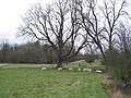
 Barn - geograph.org.uk - 339260.jpg 640 × 480; 116 KB
-
 Bridleway - geograph.org.uk - 324339.jpg 640 × 427; 89 KB
-
 Bridleway - geograph.org.uk - 386999.jpg 640 × 480; 118 KB
-
 Bridleway - geograph.org.uk - 399036.jpg 640 × 480; 81 KB
-
 Bridleway across Bean Field. - geograph.org.uk - 364296.jpg 640 × 480; 80 KB
-
 Bridleway and Barn - geograph.org.uk - 214422.jpg 640 × 480; 126 KB
-
 Bridleway beside Short Wood. - geograph.org.uk - 444073.jpg 640 × 480; 83 KB
-
 Bridleway beside the Rape. - geograph.org.uk - 460435.jpg 640 × 480; 100 KB
-
 Bridleway by the Rape. - geograph.org.uk - 444061.jpg 640 × 480; 88 KB
-

-
 Bridleway near Hemington House looking NW - geograph.org.uk - 451453.jpg 640 × 480; 104 KB
-
 Bridleway near Hemington House looking SE - geograph.org.uk - 451454.jpg 640 × 480; 103 KB
-
 Bridleway through woodland, near Laxton - geograph.org.uk - 260922.jpg 640 × 480; 102 KB
-
 Bridleway to Covington - geograph.org.uk - 588523.jpg 640 × 425; 100 KB
-
 Bridleway, Thenford Road - geograph.org.uk - 422918.jpg 640 × 434; 53 KB
-
 By South Lodge Farm - geograph.org.uk - 612702.jpg 640 × 425; 75 KB
-
 Damaged bridleway. - geograph.org.uk - 356406.jpg 640 × 480; 144 KB
-
 Entrance to Pytchley Lodge - geograph.org.uk - 422827.jpg 640 × 427; 81 KB
-
 Great Cransley - geograph.org.uk - 471095.jpg 640 × 480; 131 KB
-
 Minimalist View - geograph.org.uk - 115271.jpg 480 × 640; 92 KB
-
 On the bridleway diversion - geograph.org.uk - 444705.jpg 640 × 477; 113 KB
-
 Vehicles discouraged - geograph.org.uk - 351709.jpg 640 × 480; 90 KB
-
 View from the bridleway - geograph.org.uk - 389003.jpg 640 × 480; 89 KB
-
 Warning Ignored. - geograph.org.uk - 356432.jpg 640 × 480; 104 KB
-
 Bridleway from Yelden - geograph.org.uk - 497416.jpg 640 × 480; 102 KB
-
 Gateway to Bridlepath - geograph.org.uk - 358870.jpg 640 × 419; 71 KB


