Category:Brink 13 (Norg)
| Object location | | View all coordinates using: OpenStreetMap |
|---|
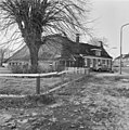
farmhouse in Noordenveld, Netherlands  | |||||
| Upload media | |||||
| Instance of | |||||
|---|---|---|---|---|---|
| Location | Norg, Drenthe, Netherlands | ||||
| Street address |
| ||||
| Located on street |
| ||||
| Heritage designation |
| ||||
 | |||||
|
This is a category about rijksmonument number 30784
|
| Address |
|
Media in category "Brink 13 (Norg)"
The following 8 files are in this category, out of 8 total.
-
 Brink.11-13.Norg.jpg 3,595 × 2,241; 1.46 MB
-
 Voor- zijgevel - Norg - 20170043 - RCE.jpg 1,188 × 1,200; 469 KB
-
 Voorgevel - Norg - 20170044 - RCE.jpg 1,197 × 1,200; 406 KB
-
 Voorgevels - Norg - 20170042 - RCE.jpg 1,200 × 949; 289 KB
-
 Zij- en achtergevel - Norg - 20170048 - RCE.jpg 1,200 × 1,200; 384 KB
-
 Zijgevel - Norg - 20170045 - RCE.jpg 1,191 × 1,200; 317 KB
-
 Zijgevel - Norg - 20170046 - RCE.jpg 1,190 × 1,200; 475 KB
-
 Zijgevel - Norg - 20170047 - RCE.jpg 1,192 × 1,200; 445 KB


