Category:Brinkburn
village in the United Kingdom  | |||||
| Upload media | |||||
| Instance of | |||||
|---|---|---|---|---|---|
| Location | Northumberland, North East England, England | ||||
 | |||||
Main Wikipedia article: Brinkburn.

Subcategories
This category has the following 8 subcategories, out of 8 total.
B
- Brinkburn railway station (4 F)
- Brinkheugh Farm (4 F)
M
- Manor House, Brinkburn (21 F)
P
T
- Tod Burn Ford (5 F)
W
- Weldon Bridge (12 F)
Media in category "Brinkburn"
The following 200 files are in this category, out of 284 total.
(previous page) (next page)-

-
 A proud tree - geograph.org.uk - 1753347.jpg 3,000 × 4,000; 2.73 MB
-
 A shed, or is it a Hut^ - geograph.org.uk - 2021505.jpg 4,000 × 3,000; 5.45 MB
-
 A697 northbound - geograph.org.uk - 3174452.jpg 640 × 454; 45 KB
-
 A697 northbound - geograph.org.uk - 3393050.jpg 640 × 361; 28 KB
-
 A697 northbound - geograph.org.uk - 3393051.jpg 640 × 480; 90 KB
-
 Abstract sculpture in the River Coquet - geograph.org.uk - 5245178.jpg 1,280 × 960; 497 KB
-
 An old kitchen range - geograph.org.uk - 2911558.jpg 2,048 × 1,536; 987 KB
-
 An unnamed meandering burn - geograph.org.uk - 3757696.jpg 1,600 × 1,200; 415 KB
-
 Approaching Brinkheugh - geograph.org.uk - 4904697.jpg 2,048 × 1,536; 1.19 MB
-
 Approaching Middleheugh - geograph.org.uk - 4904718.jpg 2,048 × 1,536; 1.13 MB
-
 Approaching West Raw - geograph.org.uk - 4912817.jpg 2,048 × 1,536; 1.09 MB
-
 Arable land at High Weldon - geograph.org.uk - 5853239.jpg 2,000 × 1,333; 458 KB
-
 Arable land north of High Weldon - geograph.org.uk - 5853234.jpg 2,000 × 1,333; 458 KB
-
 B6344 bridge over Cockshot Burn - geograph.org.uk - 3215190.jpg 3,648 × 2,736; 3.66 MB
-
 Black Burn waterfall, Cragside Estate, Northumberland - geograph.org.uk - 4530792.jpg 1,800 × 1,350; 1.46 MB
-
 Bridge across the River Coquet - geograph.org.uk - 5853245.jpg 2,000 × 1,333; 516 KB
-
 Bridge at Pauperhaugh - geograph.org.uk - 4022675.jpg 3,840 × 2,160; 2.4 MB
-
 Bridge over dismantled railway - geograph.org.uk - 1938503.jpg 1,600 × 1,200; 710 KB
-
 Bridge over the River Coquet - geograph.org.uk - 4285979.jpg 1,066 × 800; 380 KB
-
 Bridge over the River Coquet - geograph.org.uk - 4285980.jpg 1,066 × 800; 377 KB
-
 Bridge over the River Coquet at Catheugh - geograph.org.uk - 3774433.jpg 1,600 × 1,113; 412 KB
-
 Bridge over the River Coquet at Catheugh - geograph.org.uk - 3788747.jpg 1,600 × 1,200; 436 KB
-
 Bridge over the River Coquet at Pauperhaugh - geograph.org.uk - 3215195.jpg 3,648 × 2,736; 2.51 MB
-
 Bridge over the Tod Burn - geograph.org.uk - 5744438.jpg 640 × 480; 332 KB
-
 Bridge, Pauperhaugh - geograph.org.uk - 4670149.jpg 640 × 473; 135 KB
-
 Brigburn kennels - geograph.org.uk - 1884318.jpg 1,600 × 1,200; 284 KB
-
 Brinkburn Ford - geograph.org.uk - 3977129.jpg 3,872 × 2,592; 4.66 MB
-
 Brinkburn Mill - geograph.org.uk - 4076266.jpg 1,600 × 1,193; 564 KB
-
 Brinkburn Priory - arch of north gateway - geograph.org.uk - 4638325.jpg 1,024 × 769; 283 KB
-
 Brinkburn Priory - geograph.org.uk - 3454788.jpg 1,600 × 1,067; 544 KB
-
 Brinkburn Priory - geograph.org.uk - 4612534.jpg 1,985 × 1,501; 383 KB
-
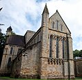 Brinkburn Priory - geograph.org.uk - 5568049.jpg 2,060 × 2,000; 1.97 MB
-
 Brinkburn Priory - tiled floor - geograph.org.uk - 4638334.jpg 1,024 × 768; 214 KB
-
 Brinkburn Priory from the east - geograph.org.uk - 4639318.jpg 1,024 × 830; 265 KB
-
 Buildings at Brinkburn Lodge - geograph.org.uk - 4076312.jpg 1,600 × 1,228; 390 KB
-
 Bus shelter - geograph.org.uk - 1872280.jpg 4,000 × 3,000; 6.16 MB
-
 Catheugh - geograph.org.uk - 1802131.jpg 640 × 480; 92 KB
-
 Catheugh - geograph.org.uk - 1802137.jpg 640 × 480; 83 KB
-
 Catheugh - geograph.org.uk - 4285977.jpg 1,066 × 800; 260 KB
-
 Catheugh Estate - geograph.org.uk - 3774439.jpg 1,600 × 1,255; 458 KB
-
 Catheugh Estate beside the River Coquet - geograph.org.uk - 3774443.jpg 1,600 × 1,162; 273 KB
-
 Cattle in pasture - geograph.org.uk - 3604011.jpg 1,600 × 1,110; 284 KB
-
 Cattle in pasture by Tod Burn - geograph.org.uk - 3604703.jpg 1,600 × 1,168; 224 KB
-
 Cockshot Ford - geograph.org.uk - 5827838.jpg 3,000 × 2,000; 6.38 MB
-
 Confluence of Tod Burn and unnamed burn - geograph.org.uk - 4348694.jpg 1,600 × 1,200; 615 KB
-
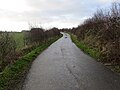
 Country road near Wingates - geograph.org.uk - 4673753.jpg 640 × 503; 214 KB
-
 Derelict building at Longhaugh - geograph.org.uk - 4906003.jpg 2,048 × 1,536; 1.44 MB
-
 Devil's Causeway (course of Roman road) - geograph.org.uk - 3604707.jpg 1,600 × 1,042; 337 KB
-
 Devil's Causeway - geograph.org.uk - 2976053.jpg 640 × 427; 52 KB
-
 Duck and goose pond - geograph.org.uk - 3389299.jpg 1,600 × 1,042; 283 KB
-
 East Raw - geograph.org.uk - 3389314.jpg 1,600 × 1,077; 517 KB
-
 Edge of woodland - geograph.org.uk - 4347884.jpg 1,600 × 1,200; 466 KB
-
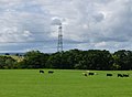
 Electricity pylons and Cockshot Burn - geograph.org.uk - 3387997.jpg 720 × 960; 174 KB
-
 Embleton Terrace - geograph.org.uk - 4119267.jpg 1,600 × 1,200; 490 KB
-
 Ewe and her lambs - geograph.org.uk - 4904663.jpg 2,048 × 1,536; 1.35 MB
-
 Ewe and lamb at Middleheugh - geograph.org.uk - 4905954.jpg 2,048 × 1,536; 1.48 MB
-
 Ewe and lambs at Longhaugh - geograph.org.uk - 4906006.jpg 2,048 × 1,536; 1.5 MB
-
 Ewe and lambs near Brinkheugh - geograph.org.uk - 4904707.jpg 2,048 × 1,536; 910 KB
-
 Ewes and lambs at Brinkheugh - geograph.org.uk - 4904691.jpg 2,048 × 1,536; 1.12 MB
-
 Farm sheds north of High Weldon - geograph.org.uk - 5853232.jpg 2,000 × 1,333; 500 KB
-
 Farm track at Thorneyhaugh - geograph.org.uk - 4905994.jpg 2,048 × 1,536; 751 KB
-
 Farm traffic - geograph.org.uk - 3603912.jpg 1,600 × 1,205; 358 KB
-
 Farmhouse at Gragend Farm - geograph.org.uk - 3215204.jpg 3,648 × 2,736; 2.78 MB
-
 Fertilizer spreading at Healeycote farm - geograph.org.uk - 1892878.jpg 4,000 × 3,000; 4.92 MB
-
 Field gateway and stile at Middleheugh - geograph.org.uk - 4905967.jpg 2,048 × 1,536; 1.29 MB
-
 Field gateway west of Longhaugh - geograph.org.uk - 4906015.jpg 2,048 × 1,536; 1.39 MB
-
 Fields beside the Devil's Causeway - geograph.org.uk - 5744229.jpg 640 × 480; 288 KB
-
 Fishing pond - geograph.org.uk - 6112864.jpg 1,600 × 1,040; 260 KB
-
 Footbridge across Maglin Burn - geograph.org.uk - 4905975.jpg 1,536 × 2,048; 1.43 MB
-
 Footbridge crossing Forest Burn - geograph.org.uk - 4906024.jpg 2,048 × 1,536; 1.73 MB
-
 Footbridge on St Oswald's Way - geograph.org.uk - 3757638.jpg 1,600 × 1,200; 640 KB
-
 Footbridge on St Oswald's Way - geograph.org.uk - 4348684.jpg 1,600 × 1,200; 616 KB
-
 Footbridge over Forest Burn - geograph.org.uk - 4347874.jpg 1,600 × 1,200; 634 KB
-
 Footbridge over the Forest Burn - geograph.org.uk - 3389325.jpg 1,600 × 1,200; 585 KB
-
 Footpath beside the Tod Burn - geograph.org.uk - 5744435.jpg 640 × 480; 363 KB
-
 Footpath Sign and Stile - geograph.org.uk - 4286385.jpg 1,066 × 800; 330 KB
-
 Footpath to West Raw farm - geograph.org.uk - 4912793.jpg 2,048 × 1,536; 1.48 MB
-
 Ford at Brinkburn - geograph.org.uk - 3977122.jpg 3,872 × 2,592; 4.87 MB
-
 Ford at Bushygap - geograph.org.uk - 3977151.jpg 3,872 × 2,592; 4.71 MB
-
 Ford at Low Hesleyhurst - geograph.org.uk - 3977632.jpg 3,872 × 2,592; 4.88 MB
-
 Ford on Rothbury to Longhorsley back road - geograph.org.uk - 4024117.jpg 3,840 × 2,160; 2 MB
-
 Ford on the Maglin Burn - geograph.org.uk - 2263229.jpg 640 × 480; 129 KB
-
 Ford on the Maglin Burn - geograph.org.uk - 2263233.jpg 640 × 480; 143 KB
-
 Ford through Forest Burn - geograph.org.uk - 3389355.jpg 1,600 × 1,228; 568 KB
-
 Forest Burn - geograph.org.uk - 2993309.jpg 1,600 × 1,068; 519 KB
-
 Forest Burn - geograph.org.uk - 2993327.jpg 1,068 × 1,600; 643 KB
-
 Forest Burn - geograph.org.uk - 2993343.jpg 1,600 × 1,068; 723 KB
-
 Former Ford at Catheugh - geograph.org.uk - 4389226.jpg 3,872 × 2,592; 4.41 MB
-

-
 Foxhole Wood Ford - geograph.org.uk - 5827848.jpg 3,000 × 2,000; 6.63 MB
-
 Garrett Lee Farm - geograph.org.uk - 2263243.jpg 640 × 480; 73 KB
-
 Grass field at Low Weldon - geograph.org.uk - 5853228.jpg 2,000 × 1,333; 244 KB
-
 Grass field west of Weldon - geograph.org.uk - 5853215.jpg 2,000 × 1,333; 315 KB
-
 Grassland beside the River Coquet - geograph.org.uk - 5853241.jpg 2,000 × 1,333; 374 KB
-
 Grassland east of Craghead - geograph.org.uk - 4912834.jpg 2,048 × 1,536; 1,020 KB
-
 Grassland north of Todstead - geograph.org.uk - 5853204.jpg 2,000 × 1,333; 372 KB
-
 Grassland south west of Brinkheugh - geograph.org.uk - 4904711.jpg 2,048 × 1,536; 938 KB
-
 Grave Memorial, Brinkburn Priory - geograph.org.uk - 3076392.jpg 600 × 800; 109 KB
-
 Grazing ewes and lambs - geograph.org.uk - 4912826.jpg 2,048 × 1,536; 1.1 MB
-
 Great Spotted Woodpecker (Dendrocopos major) - geograph.org.uk - 3774430.jpg 1,600 × 1,298; 253 KB
-
 Healey - geograph.org.uk - 2974445.jpg 640 × 480; 94 KB
-
 Healey Cote Cottage - geograph.org.uk - 3216576.jpg 1,868 × 1,401; 576 KB
-

-
 High Linn on Trough Hill - geograph.org.uk - 4083026.jpg 1,600 × 1,045; 323 KB
-
 High voltage power line - geograph.org.uk - 4904676.jpg 1,536 × 2,048; 793 KB
-
 High Weldon - geograph.org.uk - 4285985.jpg 1,066 × 800; 215 KB
-
 Hope - geograph.org.uk - 4083090.jpg 1,600 × 1,038; 233 KB
-
 Hope farm - geograph.org.uk - 4076185.jpg 1,600 × 1,025; 240 KB
-
 Interior of Brinkburn Priory - geograph.org.uk - 3076395.jpg 588 × 800; 96 KB
-
 Interior of Brinkburn Priory - geograph.org.uk - 3076399.jpg 595 × 800; 107 KB
-
 Interior of Brinkburn Priory - geograph.org.uk - 3076401.jpg 1,024 × 750; 159 KB
-
 Lambs playing around a tree - geograph.org.uk - 4904678.jpg 1,536 × 2,048; 1.18 MB
-
 Lane at Brinkburn - geograph.org.uk - 3005300.jpg 2,816 × 1,880; 1.53 MB
-
 Looking across the valley of the Maglin Burn - geograph.org.uk - 4119294.jpg 1,600 × 1,202; 383 KB
-
 Low Weldon - geograph.org.uk - 3774426.jpg 1,600 × 1,200; 341 KB
-
 Low Weldon - geograph.org.uk - 4285987.jpg 1,066 × 800; 278 KB
-
 Low Weldon - geograph.org.uk - 4285989.jpg 1,066 × 800; 301 KB
-
 Maglin Burn - geograph.org.uk - 3757639.jpg 1,600 × 1,200; 630 KB
-
 Middleheugh - geograph.org.uk - 3757679.jpg 1,600 × 1,130; 285 KB
-
 Middleheugh farm - geograph.org.uk - 4905956.jpg 2,048 × 1,536; 1.28 MB
-
 Minor road - geograph.org.uk - 3603896.jpg 1,600 × 1,200; 490 KB
-
 Minor Road at Pauperhaugh - geograph.org.uk - 2993261.jpg 2,816 × 1,880; 1.27 MB
-
 Minor road at the entry to Middleheugh Farm - geograph.org.uk - 5995872.jpg 4,000 × 3,000; 3.32 MB
-
-
 Minor road junction near North Birks - geograph.org.uk - 3604696.jpg 1,600 × 1,098; 293 KB
-
 Minor Road near Longframlington - geograph.org.uk - 5357453.jpg 4,608 × 3,456; 5.98 MB
-
 Minor road near Longhaugh - geograph.org.uk - 5995947.jpg 4,000 × 3,000; 4.04 MB
-
 Minor road near Pauperhaugh - geograph.org.uk - 5780450.jpg 2,592 × 1,944; 1.5 MB
-
 Minor road to Embleton Terrace - geograph.org.uk - 5995939.jpg 4,000 × 3,000; 4.31 MB
-
 Minor road to Pauperhaugh - geograph.org.uk - 5995942.jpg 4,000 × 3,000; 3.89 MB
-
 Mobile homes near Tindle's Hill - geograph.org.uk - 5744188.jpg 640 × 480; 328 KB
-
 Mobile homes near Tindle's Hill - geograph.org.uk - 5744189.jpg 640 × 480; 378 KB
-
 Muddy entrance to field - geograph.org.uk - 5744222.jpg 640 × 480; 295 KB
-
 Near Pauperhaugh - geograph.org.uk - 5245197.jpg 1,280 × 895; 288 KB
-
 North Entrance of Church at Brinkburn Priory - geograph.org.uk - 4076298.jpg 900 × 1,267; 254 KB
-
 Northumberland Central Railway trackbed - geograph.org.uk - 3389288.jpg 750 × 1,000; 258 KB
-
 Old stone cottage - geograph.org.uk - 4347919.jpg 1,600 × 1,200; 400 KB
-
 On St Oswald's Way - geograph.org.uk - 3757959.jpg 1,600 × 1,051; 355 KB
-
 On St Oswald's Way - geograph.org.uk - 3758419.jpg 1,600 × 1,200; 432 KB
-
 On St Oswald's Way - geograph.org.uk - 3774276.jpg 1,600 × 1,200; 715 KB
-
 Part of The National Grid - geograph.org.uk - 2427842.jpg 4,000 × 3,000; 4.62 MB
-
 Pasture and pillbox at Pauperhaugh, Brinkburn - geograph.org.uk - 1888958.jpg 2,000 × 1,500; 834 KB
-
 Pasture and trees - geograph.org.uk - 3757954.jpg 1,600 × 1,200; 390 KB
-
 Pasture at Low Hesleyhurst - geograph.org.uk - 4119302.jpg 1,600 × 1,200; 271 KB
-
 Pasture at Todstead - geograph.org.uk - 4076321.jpg 1,600 × 1,243; 326 KB
-
 Pasture near Garrett Lee - geograph.org.uk - 3603888.jpg 1,600 × 1,109; 337 KB
-
 Pasture sloping down to the River Coquet - geograph.org.uk - 4347882.jpg 1,600 × 1,200; 235 KB
-
 Path towards Low Hall Cottage - geograph.org.uk - 4912811.jpg 2,048 × 1,536; 1.4 MB
-
 Pauperhaugh - geograph.org.uk - 5245180.jpg 1,280 × 960; 462 KB
-
 Pauperhaugh Bridge - geograph.org.uk - 2060863.jpg 1,600 × 1,200; 367 KB
-
 Pauperhaugh Bridge - geograph.org.uk - 4347858.jpg 1,600 × 1,084; 339 KB
-
 Pauperhaugh Bridge - geograph.org.uk - 5245175.jpg 1,280 × 852; 334 KB
-
 Pauperhaugh Bridge - geograph.org.uk - 5377232.jpg 640 × 480; 72 KB
-
 Pauperhaugh Bridge - geograph.org.uk - 5431670.jpg 4,896 × 3,672; 6.19 MB
-
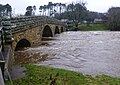 Pauperhaugh Bridge with the River Coquet in spate (1) - geograph.org.uk - 4783721.jpg 1,600 × 1,131; 344 KB
-
 Pauperhaugh Bridge with the River Coquet in spate (2) - geograph.org.uk - 4783730.jpg 1,600 × 1,075; 281 KB
-
 Pauperhaugh Bridge, Brinkburn - geograph.org.uk - 1888972.jpg 2,000 × 1,500; 801 KB
-
 Pauperhaugh, Brinkburn - geograph.org.uk - 1888994.jpg 2,000 × 1,492; 622 KB
-
 Pig, happy in mud - geograph.org.uk - 4904651.jpg 2,048 × 1,536; 1.56 MB
-
 Pigs grazing a grass field - geograph.org.uk - 4904654.jpg 2,048 × 1,536; 1.22 MB
-
 Pigs in a field between Birks and Brinkheugh - geograph.org.uk - 4904647.jpg 2,048 × 1,536; 1.15 MB
-
 Pill box defending the bridge at Pauperhaugh - geograph.org.uk - 3389390.jpg 1,600 × 1,093; 266 KB
-
 Pillbox - geograph.org.uk - 1937699.jpg 4,000 × 3,000; 3.67 MB
-
 Pillbox at Pauperhaugh – 1 - geograph.org.uk - 5245191.jpg 1,280 × 960; 408 KB
-
 Pillbox at Pauperhaugh – 2 - geograph.org.uk - 5245195.jpg 1,280 × 960; 536 KB
-
 Pillbox near Pauperhaugh - geograph.org.uk - 4906029.jpg 2,048 × 1,536; 1.16 MB
-
 Pillbox, Brinkburn - geograph.org.uk - 1888927.jpg 2,000 × 1,452; 767 KB
-
 Placid Coquet - geograph.org.uk - 5245179.jpg 1,280 × 898; 270 KB
-
 Pond - geograph.org.uk - 4347925.jpg 1,600 × 1,031; 268 KB
-
 Power line crossing farmland at Brinkheugh - geograph.org.uk - 4904666.jpg 1,536 × 2,048; 1.01 MB
-
 Primrose and Blue Violets - geograph.org.uk - 1860328.jpg 3,000 × 4,000; 3.08 MB
-
 Public bridleway to Healey - geograph.org.uk - 4076196.jpg 1,600 × 1,200; 349 KB
-
 Public Footpath to Healey - geograph.org.uk - 4076214.jpg 1,600 × 1,200; 369 KB
-
 Public footpath to Weldon Bridge - geograph.org.uk - 3604716.jpg 1,600 × 1,274; 621 KB
-
 Pylon in hayfield - geograph.org.uk - 1431316.jpg 480 × 640; 87 KB
-
 Pylon near High Linn - geograph.org.uk - 4083046.jpg 1,600 × 1,189; 367 KB
-
 Pylons beyond Hope - geograph.org.uk - 4083062.jpg 1,600 × 1,238; 306 KB
-
 Pylons galore - geograph.org.uk - 3604721.jpg 1,600 × 1,302; 340 KB
-
 Pylons striding towards Coldstream - geograph.org.uk - 4083054.jpg 1,600 × 1,055; 251 KB
-
 Railway sleepers - geograph.org.uk - 1938522.jpg 4,000 × 3,000; 5.51 MB
-
 Recycled railway track - geograph.org.uk - 1938515.jpg 3,000 × 4,000; 4.82 MB
-
 Reflection in the Coquet - geograph.org.uk - 5245183.jpg 1,064 × 1,280; 494 KB
-
 Reluctant geograph subjects - geograph.org.uk - 3604003.jpg 1,600 × 1,263; 393 KB
-
 Repair work to Pauperhaugh Bridge - geograph.org.uk - 4906054.jpg 2,048 × 1,536; 1.43 MB
-
 Repair works to Pauperhaugh Bridge - geograph.org.uk - 4906046.jpg 2,048 × 1,536; 1.38 MB
-
 River Coquet - geograph.org.uk - 4285993.jpg 1,066 × 800; 304 KB
-
 River Coquet - geograph.org.uk - 4285996.jpg 1,066 × 800; 441 KB
-
 River Coquet - geograph.org.uk - 4348686.jpg 1,600 × 1,235; 409 KB
-
 River Coquet at Pauperhaugh - geograph.org.uk - 3389399.jpg 1,600 × 992; 199 KB
-
 River Coquet in spate - geograph.org.uk - 5221324.jpg 1,600 × 1,067; 231 KB
-
 River Coquet underneath Road Bridge - geograph.org.uk - 4285992.jpg 1,066 × 800; 355 KB
-
 River Coquet, Pauperhaugh - geograph.org.uk - 4670150.jpg 640 × 480; 114 KB
-
 Rough pasture below Healey - geograph.org.uk - 4076178.jpg 1,600 × 1,200; 397 KB
-
 Rural Crossroads - geograph.org.uk - 1756813.jpg 4,000 × 2,360; 3.11 MB
-
 Scattered trees on Trough Hill - geograph.org.uk - 4083034.jpg 1,600 × 1,150; 387 KB
-
 Sheds at Todstead farm - geograph.org.uk - 5853208.jpg 2,000 × 1,333; 393 KB
-
 Sheep at Pauperhaugh - geograph.org.uk - 5245196.jpg 1,280 × 859; 425 KB
-
 Sheep grazed grassland - geograph.org.uk - 4904638.jpg 2,048 × 1,536; 1.09 MB
-
 Sheep grazing near Low Hall Cottage - geograph.org.uk - 4912802.jpg 2,048 × 1,536; 926 KB


_-_geograph.org.uk_-_3604707.jpg)


_-_geograph.org.uk_-_3774430.jpg)


_-_geograph.org.uk_-_4783721.jpg)
_-_geograph.org.uk_-_4783730.jpg)


