Category:British Columbia Highway 21
 | number: | (twenty-one) |
|---|---|---|
| Highways in British Columbia: | 1 · 2 · 3 · 4 · 5 · 6 · 7 · 14 · 15 · 16 · 17 · 19 · 20 · 21 · 24 · 28 · 29 · 37 |
highway in British Columbia | |||||
| Upload media | |||||
| Instance of | |||||
|---|---|---|---|---|---|
| Location | British Columbia, Canada | ||||
| Transport network |
| ||||
| Connects with | |||||
| Owned by |
| ||||
| Maintained by |
| ||||
| Inception |
| ||||
| Length |
| ||||
| Terminus | |||||
| |||||
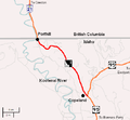
English: Media related to British Columbia Highway 21, a highway in southeastern British Columbia, Cananda, that connects Idaho State Highway 1 (at the Porthill-Rykerts Border Crossing, on the border with the United States) with British Columbia Highway 21 (northwest of Crerston).
Media in category "British Columbia Highway 21"
The following 2 files are in this category, out of 2 total.
-
 BC-21.svg 479 × 564; 20 KB
-
 Idaho Highway 1 map.png 533 × 492; 40 KB
