Category:Broughton, Lincolnshire
English: Broughton is situated on the Roman Ermine Street. Though considered by many to be a village, it is a town. It became a town in 1974 (although it still has a village hall). At the 2001 Census, the size of Broughton was slightly larger than its neighbour Brigg, which is the traditional market town of the area.
town and civil parish in North Lincolnshire, England  | |||||
| Upload media | |||||
| Instance of | |||||
|---|---|---|---|---|---|
| Location | North Lincolnshire, Lincolnshire, Yorkshire and the Humber, England | ||||
 | |||||
Subcategories
This category has the following 11 subcategories, out of 11 total.
Media in category "Broughton, Lincolnshire"
The following 200 files are in this category, out of 378 total.
(previous page) (next page)-
 A barn at Broughton Carrs - geograph.org.uk - 2168127.jpg 800 × 600; 241 KB
-
 A farm track at Broughton Carrs - geograph.org.uk - 2168125.jpg 800 × 600; 272 KB
-
 A Footpath heading towards Broughton - geograph.org.uk - 2244107.jpg 800 × 600; 329 KB
-
 A footpath to Broughton - geograph.org.uk - 2244066.jpg 800 × 600; 365 KB
-
 A footpath to Broughton - geograph.org.uk - 2245522.jpg 800 × 600; 262 KB
-
 A footpath to Castlethorpe - geograph.org.uk - 2170782.jpg 800 × 600; 243 KB
-
 A footpath to Santon - geograph.org.uk - 2244090.jpg 800 × 600; 387 KB
-
 A footpath to Santon - geograph.org.uk - 2244092.jpg 800 × 600; 212 KB
-
 A footpath to Santon - geograph.org.uk - 2245576.jpg 800 × 600; 355 KB
-
 A footpath to Santon Woods - geograph.org.uk - 2244097.jpg 800 × 600; 216 KB
-
 A footpath towards Carr Lane - geograph.org.uk - 2170787.jpg 800 × 600; 277 KB
-

-
 A pinch stile on the New River Ancholme - geograph.org.uk - 2168811.jpg 800 × 600; 330 KB
-

-

-

-

-
 A twisty B1208 - geograph.org.uk - 3919133.jpg 640 × 480; 49 KB
-
 A18 ahead on Scawby Road - geograph.org.uk - 3535060.jpg 1,024 × 713; 95 KB
-

-
 A18 lay-by north of Broughton Lane Plantation - geograph.org.uk - 5293708.jpg 5,067 × 3,801; 5.42 MB
-
 A18 roundabout from M180 junction 4 - geograph.org.uk - 3521112.jpg 640 × 413; 55 KB
-

-
 Abandoned farmland north of Broughton - geograph.org.uk - 4643411.jpg 1,024 × 768; 184 KB
-
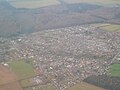 Aerial picture of Broughton.jpg 4,608 × 3,456; 3.53 MB
-
 Allotments, Brigg Road, Broughton - geograph.org.uk - 2027279.jpg 1,024 × 768; 157 KB
-
 Alongside the New River Ancholme - geograph.org.uk - 2027054.jpg 1,024 × 768; 228 KB
-
 Ancholme Bank at Broughton Bridge - geograph.org.uk - 1420201.jpg 640 × 473; 131 KB
-
 Anderson Memorial, St Mary's church, Broughton - geograph.org.uk - 6268564.jpg 2,840 × 4,726; 4.32 MB
-

-
 Appleby Lane (B1207) - geograph.org.uk - 3919074.jpg 640 × 480; 61 KB
-
 Appleby Lane (B1207) - geograph.org.uk - 3919080.jpg 640 × 480; 66 KB
-
 Appleby Lane, Broughton - geograph.org.uk - 4876920.jpg 1,600 × 1,065; 471 KB
-
 Appleby Lane, Broughton - geograph.org.uk - 4876950.jpg 1,600 × 1,065; 701 KB
-
 Appleyby Lane (Ermine Street) Broughton - geograph.org.uk - 2246334.jpg 800 × 600; 270 KB
-
 Approach to Castlethorpe Bridge - geograph.org.uk - 2036952.jpg 1,000 × 750; 832 KB
-
 Approaching Broughton Bridge - geograph.org.uk - 6116270.jpg 1,024 × 768; 183 KB
-
 Approaching Yarborough Quarry - geograph.org.uk - 2246310.jpg 800 × 600; 282 KB
-
 Artie's Mill motel - geograph.org.uk - 3293724.jpg 1,024 × 768; 152 KB
-
 Arties Mill, Castlethorpe - geograph.org.uk - 3919153.jpg 640 × 480; 91 KB
-
 B1207 heading north - geograph.org.uk - 3919047.jpg 640 × 480; 80 KB
-
 B1207 heading north - geograph.org.uk - 3919085.jpg 640 × 480; 90 KB
-
 B1208 bridge over M180 - geograph.org.uk - 3521071.jpg 640 × 322; 37 KB
-
 B1208 heading south east - geograph.org.uk - 3919102.jpg 640 × 480; 64 KB
-
 B1208 heading south east - geograph.org.uk - 3919107.jpg 640 × 480; 62 KB
-
 B1208, Castlethorpe - geograph.org.uk - 3919150.jpg 640 × 480; 52 KB
-
 Bee orchids - geograph.org.uk - 430602.jpg 480 × 640; 92 KB
-
 Birch tree - geograph.org.uk - 2161357.jpg 1,024 × 768; 174 KB
-
 Birdhouse Clough Pumping Station - geograph.org.uk - 339510.jpg 640 × 360; 108 KB
-
 Brickhills Cottages on Brigg Road - geograph.org.uk - 2170795.jpg 800 × 600; 300 KB
-
 Bridge carrying A18 over M180 - geograph.org.uk - 3521087.jpg 640 × 376; 47 KB
-
 Bridge Road - geograph.org.uk - 2027235.jpg 1,024 × 768; 208 KB
-
 Bridge Road - geograph.org.uk - 3919117.jpg 640 × 480; 59 KB
-
 Bridge Road - geograph.org.uk - 3919124.jpg 640 × 480; 47 KB
-
 Bridge Road leading towards Broughton - geograph.org.uk - 5073214.jpg 3,072 × 1,728; 1.14 MB
-
 Briggate Lodge - geograph.org.uk - 4019037.jpg 640 × 427; 84 KB
-
 Brooklands Avenue, Broughton - geograph.org.uk - 2244085.jpg 800 × 600; 222 KB
-
 Brooklands Avenue, Broughton - geograph.org.uk - 2245561.jpg 800 × 600; 207 KB
-
 Broughton Bridge - geograph.org.uk - 2011623.jpg 640 × 426; 99 KB
-
 Broughton Bridge - geograph.org.uk - 2011628.jpg 640 × 426; 98 KB
-
 Broughton Bridge - geograph.org.uk - 2168105.jpg 800 × 600; 286 KB
-
 Broughton Bridge - geograph.org.uk - 5017320.jpg 800 × 600; 120 KB
-
 Broughton Bridge - geograph.org.uk - 5017322.jpg 800 × 600; 116 KB
-
 Broughton Bridge - geograph.org.uk - 5073213.jpg 3,072 × 1,728; 1.43 MB
-
 Broughton Bridge - geograph.org.uk - 6116266.jpg 1,024 × 768; 195 KB
-

-
 Broughton Carrs (2) - geograph.org.uk - 2923821.jpg 1,024 × 768; 250 KB
-
 Broughton Carrs - geograph.org.uk - 2923813.jpg 1,024 × 768; 206 KB
-
 Broughton Cemetery - geograph.org.uk - 216006.jpg 640 × 480; 71 KB
-
 Broughton cemetery - geograph.org.uk - 4875763.jpg 1,024 × 768; 126 KB
-
 Broughton church - geograph.org.uk - 430852.jpg 640 × 381; 60 KB
-
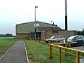 Broughton community centre - geograph.org.uk - 430621.jpg 640 × 480; 61 KB
-
 Broughton Grange, (Broughton Common) Lincolnshire - geograph-4297094.jpg 1,024 × 683; 265 KB
-
 Broughton High Street - geograph.org.uk - 1415546.jpg 640 × 425; 74 KB
-
 Broughton High Street - geograph.org.uk - 1420151.jpg 640 × 616; 148 KB
-
 Broughton Infants School - geograph.org.uk - 339499.jpg 640 × 480; 84 KB
-
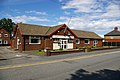
 Broughton Post Office - geograph.org.uk - 1415574.jpg 640 × 628; 114 KB
-
 Broughton Post Office - geograph.org.uk - 430617.jpg 640 × 480; 99 KB
-
 Broughton Pumping Station - geograph.org.uk - 1417612.jpg 640 × 604; 187 KB
-
 Broughton Vale Farm - geograph.org.uk - 1283323.jpg 640 × 480; 68 KB
-
 Broughton village - geograph.org.uk - 375232.jpg 640 × 426; 47 KB
-
 Broughton Village Hall - geograph.org.uk - 1415596.jpg 640 × 416; 84 KB
-
 Broughton village hall - geograph.org.uk - 430613.jpg 640 × 480; 58 KB
-
 Broughton War Memorial. - geograph.org.uk - 2323009.jpg 1,600 × 1,067; 370 KB
-
 Broughton Working Mens Club - geograph.org.uk - 1415661.jpg 640 × 425; 88 KB
-
 Broughton, Lincolnshire.jpg 640 × 480; 56 KB
-
 Brougton Silver Jubilee Clock - geograph.org.uk - 1410948.jpg 517 × 640; 118 KB
-
 Bungalows on Appleby Lane, Broughton - geograph.org.uk - 4877006.jpg 1,600 × 1,065; 505 KB
-
 Carr Lane (track) - geograph.org.uk - 3919138.jpg 640 × 480; 58 KB
-
 Carr Lane - geograph.org.uk - 1283399.jpg 640 × 480; 50 KB
-
 Carr Lane - geograph.org.uk - 1393242.jpg 640 × 480; 151 KB
-
 Carr Lane Junction - geograph.org.uk - 1283413.jpg 640 × 480; 49 KB
-
 Castlethorpe Bridge - geograph.org.uk - 2036977.jpg 1,000 × 750; 821 KB
-
 Castlethorpe Bridge over New River Ancholme - geograph.org.uk - 5073035.jpg 3,072 × 1,728; 3.55 MB
-

-

-
 Castlethorpe pipebridge - geograph.org.uk - 2026867.jpg 1,024 × 768; 151 KB
-
 Castlethorpe Weir Dyke - geograph.org.uk - 2923827.jpg 1,024 × 768; 179 KB
-
 Central Broughton.jpg 4,608 × 3,456; 3.9 MB
-

-
 Co-operative food store, Broughton, Lincs - geograph.org.uk - 5025277.jpg 3,072 × 1,728; 1.66 MB
-
 Collapsed grain silos at Bridge Farm - geograph.org.uk - 6116260.jpg 1,024 × 768; 271 KB
-
 Common Road, Broughton - geograph.org.uk - 175404.jpg 640 × 480; 98 KB
-
 Corus steelworks from across the fields - geograph.org.uk - 2030765.jpg 1,024 × 768; 126 KB
-
 Cottages on Appleton Lane, Broughton - geograph.org.uk - 4876964.jpg 1,600 × 1,065; 509 KB
-
 Cottages on Mill Lane, Broughton - geograph.org.uk - 2027273.jpg 1,024 × 768; 165 KB
-
 Crop field beside Carr Lane - geograph.org.uk - 3919135.jpg 640 × 480; 65 KB
-

-
 Crop field east of Scawby Road - geograph.org.uk - 3919049.jpg 640 × 480; 70 KB
-
 Crop field east of Scawby Road - geograph.org.uk - 3919053.jpg 640 × 480; 49 KB
-
 Crop field, Castlethorpe - geograph.org.uk - 3919148.jpg 640 × 480; 50 KB
-
 Crossing River Ancholme from M180 - geograph.org.uk - 3521062.jpg 640 × 271; 66 KB
-
 Cycle path alongside the New River Ancholme - geograph.org.uk - 6116329.jpg 1,024 × 768; 166 KB
-
 Descending the spiral stairs, St Mary's church tower - geograph.org.uk - 6267377.jpg 5,484 × 3,580; 6.99 MB
-
 Drain off Bridge Road - geograph.org.uk - 3919123.jpg 478 × 640; 99 KB
-
 Dry Stone Wall near Broughton - geograph.org.uk - 2246713.jpg 1,024 × 768; 288 KB
-
 Entering Broughton - geograph.org.uk - 1283293.jpg 640 × 480; 31 KB
-
 Entering Broughton - geograph.org.uk - 3919058.jpg 640 × 480; 57 KB
-
 Entrance to Broughton Depot - geograph.org.uk - 4174130.jpg 640 × 480; 89 KB
-
 Ermine Street Junction - geograph.org.uk - 1283441.jpg 640 × 480; 60 KB
-
 Ermine Street Roman Road - geograph.org.uk - 4174132.jpg 640 × 480; 50 KB
-
 Farm track and footpath - geograph.org.uk - 3919141.jpg 640 × 480; 42 KB
-
 Farm track near Dairy Farm - geograph.org.uk - 3919110.jpg 640 × 480; 79 KB
-
 Farm track near Springfield Plantation - geograph.org.uk - 2940403.jpg 1,024 × 768; 165 KB
-
 Farm track to Raventhorpe Farm - geograph.org.uk - 4877513.jpg 1,600 × 1,065; 523 KB
-
 Farmland east of the B1208 - geograph.org.uk - 3919100.jpg 640 × 480; 58 KB
-
 Farmland near Dairy Farm - geograph.org.uk - 3919115.jpg 640 × 480; 54 KB
-
 Farmland near Dairy Farm - geograph.org.uk - 3919119.jpg 640 × 480; 57 KB
-
 Farmland off Scawby Road Broughton - geograph.org.uk - 3831633.jpg 1,024 × 768; 156 KB
-

-
 Field Boundary near Castlethorpe - geograph.org.uk - 1287448.jpg 640 × 480; 44 KB
-
 Field edge near Broughton Vale Farm - geograph.org.uk - 2359275.jpg 1,024 × 768; 146 KB
-
 Field of oilseed rape near Broughton Bridge - geograph.org.uk - 6116269.jpg 1,024 × 768; 270 KB
-
 Fire break in West Wood - geograph.org.uk - 4876788.jpg 1,600 × 1,065; 775 KB
-
 Flowers growing at the edge of a field - geograph.org.uk - 430603.jpg 480 × 640; 180 KB
-
 Footpath to Broughton - geograph.org.uk - 4643394.jpg 1,024 × 768; 169 KB
-
 Footpath to Castlethorpe (1) - geograph.org.uk - 2027283.jpg 1,024 × 768; 267 KB
-
 Footpath to Castlethorpe (2) - geograph.org.uk - 2027286.jpg 1,024 × 768; 213 KB
-
 Footpath to Castlethorpe (3) - geograph.org.uk - 2027292.jpg 1,024 × 768; 197 KB
-
 Footpath to Castlethorpe (4) - geograph.org.uk - 2027300.jpg 1,024 × 768; 169 KB
-
 Footpath to the left ^ - geograph.org.uk - 2030795.jpg 1,024 × 768; 369 KB
-
 Gated Farm track - geograph.org.uk - 1283438.jpg 640 × 480; 71 KB
-
 Gladbury Wood from the reservoirs - geograph.org.uk - 2030667.jpg 1,024 × 768; 175 KB
-
 Gokewell Priory Farm - geograph.org.uk - 2030927.jpg 1,024 × 768; 295 KB
-
 Gokewell Priory Farm - geograph.org.uk - 3200083.jpg 640 × 432; 74 KB
-
 Gokewell Priory Farm - geograph.org.uk - 3200104.jpg 640 × 432; 71 KB
-
 Gokewell Priory Farm - geograph.org.uk - 3200127.jpg 640 × 433; 108 KB
-
 Gokewell Priory Farm - geograph.org.uk - 3200145.jpg 640 × 432; 74 KB
-
 Harvesting in Broughton Carrs (1) - geograph.org.uk - 2026911.jpg 1,024 × 768; 133 KB
-
 Harvesting in Broughton Carrs (2) - geograph.org.uk - 2026926.jpg 1,024 × 768; 134 KB
-
 Heading towards Castlethorpe Bridge - geograph.org.uk - 2168145.jpg 800 × 600; 317 KB
-
 High Street - geograph.org.uk - 2390116.jpg 427 × 640; 79 KB
-
 High Street, Broughton - geograph.org.uk - 1415642.jpg 640 × 490; 99 KB
-
 High Street, Broughton - geograph.org.uk - 2245548.jpg 800 × 600; 233 KB
-
 High Street, Broughton - geograph.org.uk - 6265638.jpg 5,568 × 3,712; 7.26 MB
-
 Himalayan Balsam - geograph.org.uk - 4643377.jpg 1,024 × 768; 328 KB
-
 House near the M180 - geograph.org.uk - 3919042.jpg 640 × 480; 63 KB
-
 Houses on Appleby Lane, Broughton - geograph.org.uk - 4876972.jpg 1,600 × 1,065; 499 KB
-
 Houses on Appleby Lane, Broughton - geograph.org.uk - 4876976.jpg 1,600 × 1,065; 551 KB
-
 Houses on South View - geograph.org.uk - 5017329.jpg 800 × 600; 87 KB
-
 Huts at Broughton Bridge - geograph.org.uk - 339431.jpg 640 × 360; 115 KB
-

-
 Irrigation pump at work on New River Ancholme - geograph.org.uk - 5073046.jpg 3,072 × 1,728; 3.63 MB
-
 Keepers Cottage - geograph.org.uk - 2030757.jpg 1,024 × 768; 219 KB
-

-
 Keepers Cottage near Raventhorpe Farm - geograph.org.uk - 4877499.jpg 1,600 × 1,065; 536 KB
-
 Lane in Castlethorpe (2) - geograph.org.uk - 2245150.jpg 1,024 × 768; 152 KB
-
 Lane in Castlethorpe - geograph.org.uk - 2245146.jpg 1,024 × 768; 167 KB
-

-

-
 Left or right ^ - geograph.org.uk - 2030812.jpg 1,024 × 768; 309 KB
-
 Lincolnshire field edge - geograph.org.uk - 2724046.jpg 800 × 600; 362 KB
-
 Lodge Farm Permissive Footpath - geograph.org.uk - 1436999.jpg 640 × 425; 109 KB
-
 Lonely pillar box on Brooklands Avenue - geograph.org.uk - 5072310.jpg 3,072 × 1,728; 1.04 MB
-
 Looking across New River Ancholme towards Castlethorpe Farm - geograph.org.uk - 5073053.jpg 3,072 × 1,728; 3.01 MB
-
 Looking across the Ancholme - geograph.org.uk - 1421375.jpg 480 × 640; 90 KB
-

-
 Looking south towards TATA Steelworks - geograph.org.uk - 2244119.jpg 800 × 600; 271 KB
-
 Looking towards Low Farm - geograph.org.uk - 164468.jpg 640 × 426; 153 KB
-
 Looking towards Old Decoy Covert - geograph.org.uk - 1420196.jpg 640 × 508; 105 KB
-

-
 M180 - geograph.org.uk - 5355751.jpg 640 × 426; 37 KB
-
 M180 approaching the River Ancholme - geograph.org.uk - 5355752.jpg 640 × 426; 49 KB
-
 M180 at Marker 34.1 - geograph.org.uk - 3792178.jpg 1,600 × 1,011; 319 KB
-
 M180 bridge over the New River Ancholme - geograph.org.uk - 6085495.jpg 1,024 × 768; 171 KB
-
 M180 eastbound - geograph.org.uk - 3919043.jpg 640 × 480; 49 KB
-
 M180 eastbound, Junction 4 - geograph.org.uk - 4174136.jpg 640 × 480; 67 KB
-
 M180 misty bridge - geograph.org.uk - 3792173.jpg 2,711 × 1,667; 1.99 MB
-
 M180 motorway - geograph.org.uk - 2428920.jpg 2,256 × 1,496; 862 KB
-
 M180 passes under the A18 - geograph.org.uk - 3674996.jpg 640 × 480; 54 KB
-
 M180 towards Grimsby - geograph.org.uk - 3919151.jpg 640 × 480; 42 KB
-
 M180 west towards junction 4 - geograph.org.uk - 327474.jpg 640 × 480; 58 KB
-
 M180 westbound near Castlethorpe - geograph.org.uk - 3674990.jpg 640 × 481; 35 KB
-
 MAN vehicle depot near Forest Pines - geograph.org.uk - 4875771.jpg 1,024 × 768; 190 KB
-
 Mini roundabout on the A18 - geograph.org.uk - 3919155.jpg 640 × 480; 51 KB
-

-
 Morning mist on the M180 - geograph.org.uk - 3791761.jpg 2,834 × 1,616; 2.1 MB
-
 Near Broughton Bridge - geograph.org.uk - 1417580.jpg 640 × 425; 106 KB
-
 Near Broughton Grange - geograph.org.uk - 1420190.jpg 640 × 425; 87 KB
-
 Near Lodge Farm - geograph.org.uk - 338430.jpg 640 × 360; 140 KB


_-_geograph.org.uk_-_3919074.jpg)
_-_geograph.org.uk_-_3919080.jpg)


_Broughton_-_geograph.org.uk_-_2246334.jpg)


_-_geograph.org.uk_-_2923821.jpg)


_Lincolnshire_-_geograph-4297094.jpg)


_-_geograph.org.uk_-_3919138.jpg)


_-_geograph.org.uk_-_2027283.jpg)
_-_geograph.org.uk_-_2027286.jpg)
_-_geograph.org.uk_-_2027292.jpg)
_-_geograph.org.uk_-_2027300.jpg)


_-_geograph.org.uk_-_2026911.jpg)
_-_geograph.org.uk_-_2026926.jpg)


_-_geograph.org.uk_-_2245150.jpg)


