Category:Broughton Hall, Lilyfield
English: Broughton Hall, Lilyfield is a heritage-listed former residence, convalescent hospital and psychiatric clinic at Balmain Road, Lilyfield, Inner West Council, New South Wales, Australia. It was built c. 1841. It variously served as a residence for prominent businessmen and public figures (1841-1914), the No. 13 Australian Army Hospital during World War I, and the Broughton Hall Psychiatric Clinic (1921-1976). It was merged into Rozelle Hospital along with the adjacent Callan Park Hospital for the Insane in 1976, during which time it became the first premises for the Rivendell Child, Adolescent and Family Unit. It thereafter fell into disuse, suffering severe damage from fire and vandalism.
"Heritage place or item located at Balmain Road, Lilyfield New South Wales, Australia"  | |||||
| Upload media | |||||
| Instance of | |||||
|---|---|---|---|---|---|
| Location | New South Wales, AUS | ||||
| Heritage designation |
| ||||
 | |||||
Media in category "Broughton Hall, Lilyfield"
The following 14 files are in this category, out of 14 total.
-
 831 - Rozelle Hospital - Broughton Hall - SHR Plan No 2987 (5012311b100).jpg 707 × 1,000; 279 KB
-
 Broughton Hall in 1916, during World War 1.jpg 1,745 × 1,404; 1.62 MB
-
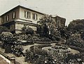
 Broughton Hall in 1943 - Gardens.jpg 1,400 × 1,050; 521 KB
-
 Broughton Hall in 1943 - Interior.jpg 1,400 × 1,050; 93 KB
-
 Broughton Hall in 1943.jpg 1,400 × 1,050; 457 KB
-
 Broughton Hall, Callan Park, in 2020 - facing the garden area 01.jpg 2,816 × 2,112; 3.85 MB
-
 Broughton Hall, Callan Park, in 2020 - facing the garden area 02.jpg 2,816 × 2,112; 3.08 MB
-
 Broughton Hall, Callan Park, in 2020 - garden feature.jpg 2,816 × 2,112; 3.42 MB
-
 Broughton Hall, Callan Park, in 2020 - part of the garden area.jpg 2,816 × 2,112; 3.97 MB
-
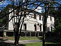
 Broughton Hall, Callan Park, in 2020 - side view.jpg 2,816 × 2,112; 4.4 MB
-
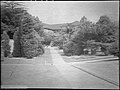
 Broughton Hall, Callan Park, in 2020 - view along Church Street.jpg 2,816 × 2,112; 2.62 MB
-
 Broughton Hall, undated image.jpg 811 × 592; 566 KB
-
 Broughton Hall, unknown date, showing part of the garden area.jpg 781 × 592; 486 KB
-
 Municipality of Leichhardt Map, printed 1939.jpg 1,715 × 1,701; 1.94 MB
.jpg)


