Category:Building of povit school, Okhtyrka
| Object location | | View all coordinates using: OpenStreetMap |
|---|
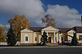
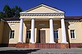
Українська: Колишнє повітове училище в Охтирці (Сумська область), вулиця Перемоги, 1. Збудоване 1813 року. Один із корпусів сучасної гімназії. Пам’ятка архітектури, приклад провінційного класицизму (джерела: 1, 2, 3).
.JPG) | |||||
| Upload media | |||||
| Instance of | |||||
|---|---|---|---|---|---|
| Location | Okhtyrka, Sumy Oblast, Ukraine | ||||
| Heritage designation |
| ||||
 | |||||
Media in category "Building of povit school, Okhtyrka"
The following 9 files are in this category, out of 9 total.
-
 59-102-0038 Okhtyrka Peremogy SAM 8478.jpg 4,592 × 3,056; 3.78 MB
-
 59-102-0038 Перемоги, 1. Колишнє повітове училище.jpg 3,264 × 2,448; 2.15 MB
-
 Okhtyrka Lenina SAM 8480 59-102-0038.JPG 4,592 × 3,056; 2.47 MB
-
 Okhtyrka Povitove Uchylysche 01 Lenina Ploscha 1 (YDS 5690).JPG 5,302 × 2,409; 5.19 MB
-
 Охтирка P1490437 Повітове училище.jpg 4,000 × 2,672; 2.36 MB
-
 Охтирка P1490450 Повітове училище.jpg 3,555 × 2,375; 2.23 MB
-
 Охтирка, Успенська площа.jpg 5,334 × 3,543; 12.65 MB
-
 Повітове училище 59-102-0038.jpg 4,608 × 3,072; 4.42 MB
-
 Початкова школа Охтирської гімназії.jpg 3,720 × 1,441; 3.57 MB


