Category:Bunder Mühle
| Object location | | View all coordinates using: OpenStreetMap |
|---|
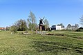
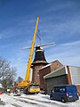
smock mill  | |||||
| Upload media | |||||
| Instance of | |||||
|---|---|---|---|---|---|
| Location | Bunde, Leer, Lower Saxony, Germany | ||||
| Heritage designation | |||||
 | |||||
Subcategories
This category has the following 2 subcategories, out of 2 total.
I
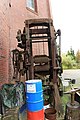
- Interior of Bunder Mühle (19 F)
V
- Views from Bunder Mühle (3 F)
Media in category "Bunder Mühle"
The following 38 files are in this category, out of 38 total.
-
 Bunde - Weener Straße - Bunder Mühle 01 ies.jpg 5,616 × 3,745; 19.14 MB
-
 Bunde - Weener Straße - Bunder Mühle 02 ies.jpg 3,744 × 5,616; 18.73 MB
-
 Bunde - Weener Straße - Bunder Mühle 03 ies.jpg 5,616 × 3,744; 14.02 MB
-
 Bunde - Weener Straße - Bunder Mühle 04 ies.jpg 5,616 × 3,744; 19.16 MB
-
 Bunde - Weener Straße - Bunder Mühle 05 ies.jpg 5,616 × 3,744; 13.21 MB
-
 Bunde - Weener Straße - Bunder Mühle 06 ies Ausschnitt.jpg 2,156 × 1,555; 3.56 MB
-
 Bunde - Weener Straße - Bunder Mühle 06 ies.jpg 5,616 × 3,745; 23.04 MB
-
 Bunde - Weener Straße - Bunder Mühle 07 ies.jpg 3,744 × 5,616; 15.18 MB
-
 Bunde - Weener Straße - Bunder Mühle 08 ies.jpg 5,616 × 3,746; 14.89 MB
-
 Bunde - Weener Straße - Bunder Mühle 09 ies.jpg 5,616 × 3,744; 14.39 MB
-
 Bunde - Weener Straße - Bunder Mühle 10 ies.jpg 3,743 × 5,616; 17.51 MB
-
 Bunde - Weener Straße - Bunder Mühle 11 ies.jpg 5,616 × 3,743; 21.21 MB
-
 Bunde - Weener Straße - Bunder Mühle 12 ies.jpg 5,616 × 3,744; 20.76 MB
-
 Bunde - Weenerstraße + Bunder Mühle 01 ies.jpg 3,744 × 5,616; 16.25 MB
-
 Bunde - Weenerstraße - Bunder Mühle 10 ies.jpg 3,744 × 5,616; 14.97 MB
-
 Bunde - Weenerstraße - Bunder Mühle 11 ies.jpg 3,744 × 5,616; 17.73 MB
-
 Bunde - Weenerstraße - Bunder Mühle 12 ies.jpg 3,744 × 5,616; 19.06 MB
-
 Bunde - Weenerstraße - Bunder Mühle 13 ies.jpg 5,616 × 3,744; 19.66 MB
-
 Bunde - Weenerstraße - Bunder Mühle 14 ies.jpg 3,743 × 5,616; 15.46 MB
-
 Bunde - Weenerstraße - Bunder Mühle 15 ies.jpg 5,616 × 3,745; 15.89 MB
-
 Bunde - Weenerstraße - Bunder Mühle 16 ies.jpg 3,743 × 5,616; 18.25 MB
-
 Bunde - Weenerstraße - Bunder Mühle 17 ies.jpg 3,743 × 5,616; 19.99 MB
-
 Bunde - Weenerstraße - Bunder Mühle 18 ies.jpg 3,744 × 5,616; 19.17 MB
-
 Bunde - Weenerstraße - Bunder Mühle 19 ies.jpg 3,743 × 5,616; 18.62 MB
-
 Bunde - Weenerstraße - Bunder Mühle 20 ies.jpg 3,744 × 5,616; 20.51 MB
-
 Bunde - Zum Sportplatz - Bunder Park + Bunder Mühle 01 ies.jpg 3,744 × 5,616; 19.87 MB
-
 Bunde - Zum Sportplatz - Bunder Park + Bunder Mühle 02 ies.jpg 3,744 × 5,616; 20.62 MB
-
 Bunde - Zum Sportplatz - Bunder Park + Bunder Mühle 03 ies.jpg 5,616 × 3,744; 22 MB
-
 Bunde - Zum Sportplatz - Bunder Park + Bunder Mühle 04 ies.jpg 5,616 × 3,745; 23.13 MB
-
 Bunde - Zum Sportplatz - Bunder Park + Bunder Mühle 05 ies.jpg 3,744 × 5,616; 21.28 MB
-
 Bunde - Zum Sportplatz - Bunder Park + Bunder Mühle 06 ies.jpg 5,616 × 3,744; 23.21 MB
-
 Bunde Mühle.jpg 2,304 × 3,072; 947 KB
-
 Mühle Bunde.jpg 2,304 × 3,072; 1.91 MB
-
 Wind mill Bunde 01.jpg 2,431 × 3,631; 1.53 MB
-
 Wind mill Bunde 02.jpg 3,000 × 4,000; 1.85 MB
-
 Wind mill Bunde 03.jpg 3,000 × 4,000; 2.34 MB
-
 Wind mill Bunde 04.jpg 3,000 × 4,000; 2.22 MB
-
 Wind mill Bunde 05.jpg 3,000 × 4,000; 2.37 MB


