Category:Burg Rumburg
This is the category of the Bavarian Baudenkmal (cultural heritage monument) with the ID D-1-76-137-42 (Wikidata)
|
castle  Hrad Rumburg | |||||
| Upload media | |||||
| Instance of | |||||
|---|---|---|---|---|---|
| Location | Enkering, Kinding, Eichstätt, Upper Bavaria, Bavaria, Germany | ||||
| Street address |
| ||||
| Heritage designation | |||||
 | |||||
Media in category "Burg Rumburg"
The following 27 files are in this category, out of 27 total.
-
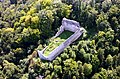
 2018 Burg Rumburg 01.jpg 21,859 × 5,972; 17.05 MB
-
 Burg Rumburg 10.jpg 800 × 600; 589 KB
-
 Burg Rumburg 11.jpg 600 × 800; 577 KB
-
 Burg Rumburg 12.jpg 800 × 600; 487 KB
-
 Burg Rumburg 13.jpg 800 × 600; 563 KB
-
 Burg Rumburg 14.jpg 800 × 600; 674 KB
-
 Burg Rumburg 15.jpg 800 × 600; 541 KB
-
 Burg Rumburg 2.jpg 600 × 800; 223 KB
-
 Burg Rumburg 3.jpg 800 × 600; 226 KB
-
 Burg Rumburg 4.jpg 800 × 600; 636 KB
-
 Burg Rumburg 5.jpg 800 × 641; 510 KB
-
 Burg Rumburg 6.jpg 800 × 600; 406 KB
-
 Burg Rumburg 7.jpg 800 × 600; 504 KB
-
 Burg Rumburg 8.jpg 800 × 600; 553 KB
-
 Burg Rumburg 9.jpg 800 × 600; 428 KB
-
 Burg Rumburg Gesamt.jpg 800 × 600; 168 KB
-
 Burg Rumburg-Lageplan.png 796 × 494; 864 KB
-
 Burg Rumburg.jpg 800 × 600; 141 KB
-
 Burgruine Rumburg im Winter, Gesamtansicht.jpg 740 × 1,099; 194 KB
-
 Die Rumburg bei Enkering.jpg 3,000 × 4,000; 2.1 MB
-
 Enkering Nord Rumburg.jpg 6,000 × 4,000; 6.39 MB
-
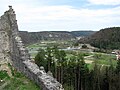
 Enkering Rumburg vom Schellenberg gesehen 090413.JPG 3,872 × 2,592; 7.03 MB
-
 Luftbild-rumburg.jpg 3,196 × 2,102; 7.01 MB
-
 Rumburg (Enkering).jpg 6,000 × 4,000; 6.72 MB
-
 Rumburg GO-1.jpg 2,592 × 1,944; 1.91 MB
-
 Rumburg GO-2.jpg 2,592 × 1,944; 1.16 MB
-
 Schellenberg Rumburg.jpg 1,336 × 1,009; 359 KB


.jpg)


