Category:Burg Rundeck
This is the category of the Bavarian Baudenkmal (cultural heritage monument) with the ID D-1-76-137-50 (Wikidata)
|
castle  | |||||
| Upload media | |||||
| Instance of | |||||
|---|---|---|---|---|---|
| Location | Erlingshofen, Kinding, Eichstätt, Upper Bavaria, Bavaria, Germany | ||||
| Street address |
| ||||
| Heritage designation | |||||
 | |||||
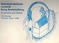
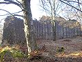
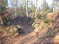
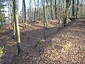
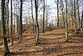
Deutsch: Die Ruine der Burg Rundeck befindet sich in der Fränkischen Alb, etwa 5,5 Kilometer westlich von Kinding im Bundesland Bayern in Deutschland
English: Rundeck castle near Kinding-Erlingshofen (Anlauter valley, Landkreis Eichstätt, Upper Bavaria, Germany)
Media in category "Burg Rundeck"
The following 11 files are in this category, out of 11 total.
-
 Burg Rundeck 2.jpg 600 × 800; 229 KB
-
 Burg Rundeck 3.jpg 800 × 584; 106 KB
-
 Burg Rundeck 4.jpg 800 × 600; 230 KB
-
 Burg Rundeck 5.jpg 800 × 600; 217 KB
-
 Burg Rundeck 6.jpg 800 × 600; 207 KB
-
 Burg Rundeck 7.jpg 800 × 600; 214 KB
-
 Burg Rundeck 8.jpg 600 × 800; 185 KB
-
 Burg Rundeck-Lageplan.png 1,167 × 661; 1.56 MB
-
 Burg Rundeck.jpg 800 × 543; 238 KB
-
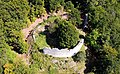 Luftaufnahme-rundeck.jpg 3,232 × 2,000; 2.44 MB
-
 Luftbild-rundeck.jpg 3,232 × 2,000; 6.82 MB


