Category:Burg Weißenstein (Steinwald)
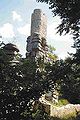
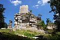
Deutsch: Die Ruine Weißenstein steht auf dem 863 m hohen Weißenstein Im Steinwald zwischen Waldershof und Erbendorf in der nördlichen Oberpfalz, etwa 9 Kilometer nordlich von Erbendorf im Bundesland Bayern in Deutschland.
 | |||||
| Upload media | |||||
| Instance of | |||||
|---|---|---|---|---|---|
| Location | Waldershof, Tirschenreuth, Upper Palatinate, Bavaria, Germany | ||||
| Street address |
| ||||
| Heritage designation | |||||
| Width |
| ||||
| Length |
| ||||
| Area |
| ||||
| Elevation above sea level |
| ||||
| official website | |||||
 | |||||
Subcategories
This category has only the following subcategory.
M
Media in category "Burg Weißenstein (Steinwald)"
The following 25 files are in this category, out of 25 total.
-
 Burg Weißenstein (Steinwald) - panoramio - Herold Manfred (6).jpg 1,800 × 1,200; 495 KB
-
 Burg Weißenstein (Steinwald) - panoramio - Herold Manfred (7).jpg 1,800 × 1,200; 501 KB
-
 Burgruine Weißenstein im Steinwald.jpg 3,626 × 2,685; 6.73 MB
-
 Burgruine-Weissenstein,Gesamtansicht.JPG 3,088 × 2,056; 3.21 MB
-
 Burgruine-Weissenstein,Gesamtansicht2.JPG 3,088 × 2,056; 3.01 MB
-
 Holzstich - Waldershof - Burgruine Weißenstein - Link - 1847.jpg 1,360 × 1,337; 444 KB
-
 Ruine Weißenstein (Steinwald).PNG 732 × 408; 406 KB
-
 Ruine Weissenstein.jpg 960 × 1,280; 992 KB
-
 Ruine Weißenstein (aus Innenhof).jpg 3,962 × 2,981; 2.65 MB
-
 Ruine Weißenstein (vor Brücke).jpg 4,002 × 3,005; 2.41 MB
-
 Ruine Weißenstein Blick vom Hauptturm.jpg 2,646 × 3,571; 5.79 MB
-
 Ruine Weißenstein UP.jpg 5,440 × 2,254; 15.64 MB
-
 Statue Weißenstein Waldershof.jpg 2,135 × 3,420; 3.91 MB
-
 Steinwald - Juli 2009 - Burgruine Weissenstein II.jpg 3,072 × 2,304; 1.7 MB
-
 Weissenstein 3.jpg 200 × 300; 21 KB
-
 Weissenstein HDR (oben) NORMAL (unten).jpg 3,626 × 5,400; 9.41 MB
-
 Weissenstein-1.jpg 768 × 1,024; 556 KB
-
 Weissenstein-3 WJP.jpg 1,024 × 768; 704 KB
-
 Weissenstein2.jpg 2,140 × 1,427; 283 KB
-
 Weißenstein 01 2011-3.jpg 600 × 800; 95 KB
-
 Weißenstein 02 2011-3.jpg 800 × 600; 93 KB
-
 Weißenstein 03 2011-03.jpg 600 × 800; 73 KB
-
 Weißenstein 04 2011-3.jpg 800 × 600; 127 KB
-
 Weißenstein 05 2011-3.jpg 800 × 600; 123 KB
-
 Weißenstein Steinwald 2015.JPG 4,752 × 3,168; 5.89 MB
_-_panoramio_-_Herold_Manfred_(6).jpg)
_-_panoramio_-_Herold_Manfred_(7).jpg)


.PNG)

.jpg)
.jpg)


_NORMAL_(unten).jpg)


