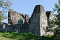
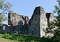
Category:Burgruine Attinghausen
| Object location | | View all coordinates using: OpenStreetMap |
|---|
ruined medieval castle in Attinghausen in the canton of Uri, Switzerland  | |||||
| Upload media | |||||
| Instance of | |||||
|---|---|---|---|---|---|
| Part of | |||||
| Location | Attinghausen, Uri, Switzerland | ||||
| Heritage designation | |||||
| Inception |
| ||||
 | |||||
Media in category "Burgruine Attinghausen"
The following 2 files are in this category, out of 2 total.
-
 Attinghausen-Burg.jpg 1,200 × 800; 1.39 MB
-
 Attinghausen-Burgruine.jpg 2,000 × 1,420; 3.2 MB
