Category:Byker Metro Bridge
| Object location | | View all coordinates using: OpenStreetMap |
|---|
railway bridge in Newcastle upon Tyne .jpg) | |||||
| Upload media | |||||
| Instance of | |||||
|---|---|---|---|---|---|
| Location |
| ||||
 | |||||
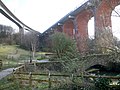
English: The Byker Metro Bridge (also known as the Byker Viaduct) is an 820 metre long curved double-track light railway bridge that carries the Tyne and Wear Metro over the River Ouseburn in Newcastle upon Tyne. It carries the line from Manors Metro station in the city centre to the west to Byker Metro station in the area of Byker to the east, over the lower Ouseburn valley, with the river emptying into the north side of the River Tyne, around 500m to the south.
Designed by Ove Arup and Partners, it opened on 11th November 1982. With spans up to 68.9m long, the main portion over the valley consists of six spans, rising to 30m above the ground; on the east side the bridge continues as a lower elevated section. It was the first such structure in Britain to be built using cantilevered concrete sections with glued joints.
It is one of three high level bridges in close proximity making the same crossing, with the Ouseburn railway Viaduct to the north and the Byker road bridge to the south. The bridge and elevated section form an S-curve, which takes the track over the Byker road bridge at its east end.
Media in category "Byker Metro Bridge"
The following 12 files are in this category, out of 12 total.
-
 Byker Metro Bridge, 1 October 2011.jpg 1,280 × 960; 1.02 MB
-
 Byker Metro Bridge, 28 August 2011.jpg 2,601 × 1,923; 1.2 MB
-
 Byker Metro Bridge, from the Ouseburn - geograph.org.uk - 760489.jpg 640 × 426; 37 KB
-
 Byker Metro Flyover - geograph.org.uk - 66591.jpg 640 × 480; 74 KB
-
 Byker Viaduct from Metro train 4067.jpg 1,280 × 960; 509 KB
-
 Clifford Street Cycle Path - geograph.org.uk - 195997.jpg 640 × 480; 55 KB
-
 Crawford's Bridge, Ouseburn - geograph.org.uk - 1775388.jpg 640 × 480; 85 KB
-
 Metro line runs to Byker Station - geograph.org.uk - 1162716.jpg 640 × 480; 130 KB
-
 Ouseburn Valley below the Metro Bridge - geograph.org.uk - 1775112.jpg 768 × 1,024; 294 KB
-

-

-


.jpg)
.jpg)